California State Route 58
State Route 58 (SR 58) is a major east-west state highway in the U.S. state of California that runs across the Coast Ranges, the southern San Joaquin Valley, the Tehachapi Mountains, which border the southern Sierra Nevada, and the Mojave Desert. It runs between U.S. Route 101 near Santa Margarita and Interstate 15 in Barstow. It has junctions with Interstate 5 near Buttonwillow, State Route 99 in Bakersfield, State Route 202 in Tehachapi, State Route 14 near Mojave, and U.S. Route 395 at Kramer Junction. SR 58 also provides access to Edwards Air Force Base. At various points it is known as the Calf Canyon Highway, Carrisa Highway, Bakersfield-McKittrick Highway, Rosa Parks Highway, Rosedale Highway, Barstow-Bakersfield Highway, Kern County Korean War Veterans Memorial Highway, and Mojave-Barstow Highway.
| ||||
|---|---|---|---|---|
 SR 58 highlighted in red | ||||
| Route information | ||||
| Defined by Streets and Highways Code § 358 | ||||
| Maintained by Caltrans | ||||
| Length | 241 mi[1] (388 km) | |||
| Existed | 1964–present | |||
| Major junctions | ||||
| West end | ||||
| ||||
| East end | ||||
| Location | ||||
| Counties | San Luis Obispo, Kern, San Bernardino | |||
| Highway system | ||||
| ||||

Route description
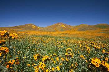
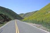
State Route 58 between Santa Margarita and Buttonwillow is a winding mountain road through a thinly populated area. From its westernmost terminus at US 101 near Santa Margarita, a few miles north of San Luis Obispo, SR 58 heads east along the former US 101 (El Camino Real) for one mile. SR 58 then heads east and up the winding mountain road, passing through a thinly populated area and an intersection with SR 229. Alternatives such as SR 46 to the north or SR 166 to the south are recommended, as much of this section of SR 58 is prohibited to truck traffic. However, this section of SR 58 does pass through the Carrizo Plain, which is known for its scenic beauty and geological features, including the San Andreas Fault. SR 58 then takes another winding road before joining with State Route 33 (SR 33) in the small town of McKittrick. SR 33 then splits at the north end of McKittrick before SR 58 then enters another, but brief winding road. SR 58 then proceeds northeast for several miles before changing to an east-west alignment and reaching Buttonwillow. A few miles later, SR 58 has an interchange with Interstate 5 (I-5). Approximately 7 miles (11 km) east of I-5, SR 58 briefly joins SR 43 before continuing east and eventually reaching the Bakersfield city limits.
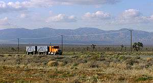
State Route 58 joins State Route 99 for about 2 miles (3.2 km) through Bakersfield before splitting as a freeway and heading east. SR 58 briefly enters expressway status with two at-grade intersections in the Caliente area before resuming freeway status east of Caliente. SR 58 then reaches the Tehachapi city limits and traverses the Tehachapi Pass before dropping out of the Tehachapi Mountains into the Antelope Valley at the town of Mojave. Shortly after an interchange with State Route 14, SR 58 reverts to an expressway east of Mojave before resuming freeway status bypassing North Edwards, Edwards Air Force Base, Boron, and Kramer Junction. Approximately 10 miles (16 km) east of an interchange with U.S. Route 395, SR 58 resumes expressway status with two lanes in each direction until just before reaching the easternmost terminus at Interstate 15 in Barstow.
State Route 58 is a freeway from its south junction with SR 99 in Bakersfield (the West Bakersfield Interchange) to several miles east of Mojave (a freeway bypass of Mojave was completed in 2004), except for two at-grade intersections two miles (3.2 km) apart in the Caliente area. There is another at-grade intersection east of Mojave and west of the main Edwards AFB north gate exit where California City Boulevard intersects it. Other freeway segments are bypasses of Boron, Kramer Junction (a freeway bypass of Kramer and Kramer Junction was completed in 2019), and Barstow. Except for the Boron-Kramer Junction freeway bypass, SR 58 is primarily a four-lane expressway (two lanes per direction) from just east of Kramer Junction up to the Barstow bypass segment.
State Route 58 takes the southernmost route through the Sierra Nevada and allows motorists to travel between Northern California and points to the east, such as Las Vegas and Interstate 40, without having to face the extreme traffic congestion of greater Los Angeles. State Route 58 and Interstate 80 are the only freeways to cross the Sierra Nevada. The route also offers an alternative to the often treacherous Donner Pass to truckers traveling from the San Francisco Bay Area to points eastward; prior to the construction of Interstate 80, the road (as U.S. Route 466) was heavily used for this purpose.
SR 58 is part of the California Freeway and Expressway System,[2] and east of I-5 is part of the National Highway System,[3] a network of highways that are considered essential to the country's economy, defense, and mobility by the Federal Highway Administration.[4] SR 58 is eligible for the State Scenic Highway System,[5] but it is not officially designated as a scenic highway by the California Department of Transportation.[6] SR 58 has several names throughout its length, including the Blue Star Memorial Highway (for its entire length); the Kern County Korean War Veterans Memorial Highway, for the section from SR 184 to the Kern County/San Bernardino County Line; and the Rosa Parks Highway, for the section between SR 99 and SR 184. The Korean War Veterans name honors the approximately 8,120 veterans from Kern County, while the section named for Rosa Parks honors the civil rights activist.[7] The portion of SR 58 from Barstow to Bakersfield is sometimes referred to as the Barstow–Bakersfield Highway.[8]
History
State Route 58 did not exist as a California sign route until 1964, although previous to 1964, it was part of California Legislative Route 58. The other part of Legislative Route 58 is California's segment of Interstate 40; previous to 1964 it was a segment of US 66.
Prior to 1964 the segment of State Route 58 between Bakersfield and Barstow was signed U.S. Route 466. Also at that time, the segment of SR 58 between State Route 33 at McKittrick and State Route 99 in Bakersfield was signed as State Route 178. Although it was proposed for signing as Route 178 in 1934, the segment of Legislative Route 58 between US 101 near Santa Margarita and State Route 33 at McKittrick was not signed prior to 1964.
Note that US 466 was co-signed with US 99, now State Route 99, between Bakersfield and Famoso Junction. Between Famoso and US 101 at Paso Robles, US 466 largely became SR 46.
The eastern terminus was originally at I-15 in northeastern Barstow. SR 58 was rerouted to I-15 in Barstow south of the I-40 interchange. The former eastern terminus is now known as "Old Highway 58."
Future
| |
|---|---|
| Location | Barstow –Bakersfield |
| Length | 147 mi (237 km) |
Extending I-40 westward to I-5: the missing link
California has long sought federal funds for an extension of Interstate 40 west of Barstow; any such extension would use the general path of SR 58, if not existing highway, at least as far west as Bakersfield, whose rapid growth has made it a significant generator of traffic in its own right. The desired highway is being built piecemeal as Caltrans has funds available, at least between Mojave and Barstow. Two at-grade intersections within 1 1⁄2 miles (2.4 km) of each other around mile 76, roughly halfway between Bakersfield and Mojave (Bealeville Road and California State Route 223), would have to be either closed or upgraded to interchanges for the whole of SR 58 to be up to Interstate standards. Caltrans has built bypasses of Mojave and Barstow up to Interstate standards.
In the Kramer Junction area, Caltrans planned to realign and widen a 13.3-mile segment of State Route 58 from 0.4 miles west of the Kern/San Bernardino County line to a point approximately 7.5 miles east of Kramer Junction from a two-lane conventional highway to a four-lane expressway, and construct an interchange at the SR 58/US 395 junction to replace the then at-grade junction of SR 58 and US 395 in Kramer Junction.[9] A groundbreaking ceremony for the Kramer Junction Expressway was held on January 19, 2018.[10] The bypass was opened to traffic on October 24, 2019.[11]
In western Bakersfield, the Westside Parkway, a freeway running from the intersection of Heath Road and Stockdale Highway east to Truxtun Avenue, was completed on April 15, 2015, with interchanges in between at Allen Road, Calloway Drive, Coffee Road, and Mohawk Street.[12] Opening in stages since 2013, the road is currently under the jurisdiction of the city of Bakersfield. As part of the Centennial Corridor project, Caltrans is building an eastern extension of the Westside Parkway to the current junction of highways 58 and 99 at the West Bakersfield Interchange, but construction has been controversial since it displaced dozens of homes and businesses;[13] by September 2017, all but a few buildings in the path had been demolished.[14] Once the connection to Highway 99 is completed (which is expected to occur in 2022), Highway 58 will then be rerouted onto Stockdale Highway and the Westside Parkway (and the city will transfer the latter's jurisdiction to Caltrans), with later plans to upgrade Stockdale Highway from Heath Road west to Interstate 5 as a freeway.[15]
The San Luis Obispo Planning Commission is considering a permit application for the California Valley Solar Ranch and has released a Draft Environmental Impact Report with a public comment period closure date November 1, 2010. Among the points raised in the DEIR is the aesthetic impact on the viewshed which would be particularly troublesome if large industrial scale arrays of solar panels are placed north of Route 58 in the section of road just east of Soda Lake Road.
Business loops
Mojave
| |
|---|---|
| Location | Mojave, California |
State Route 58 Business is a business route of California State Route 58 in Mojave. It provides access to downtown Mojave as Mojave-Barstow Highway. It also follows mostly the former routing of U.S. Route 466.
Tehachapi
| |
|---|---|
| Location | Tehachapi, California |
State Route 58 Business is a business route of California State Route 58 in Tehachapi. It provides access to downtown Tehachapi as Tehachapi Boulevard. It also follows the former routing of U.S. Route 466 and is overlapped with State Route 202.
Boron
| |
|---|---|
| Location | Boron, California |
State Route 58 Business is a business route of California State Route 58 in Boron. It provides access to downtown Boron as Twenty Mule Team Road. It also follows the former routing of U.S. Route 466. It is signed from westbound Route 58 approaching the San Bernardino–Kern county line and the beginning of the Boron bypass.
Major intersections
Except where prefixed with a letter, postmiles were measured on the road as it was in 1964, based on the alignment that existed at the time, and do not necessarily reflect current mileage. R reflects a realignment in the route since then, M indicates a second realignment, L refers an overlap due to a correction or change, and T indicates postmiles classified as temporary (for a full list of prefixes, see the list of postmile definitions).[16] Segments that remain unconstructed or have been relinquished to local control may be omitted. The numbers reset at county lines; the start and end postmiles in each county are given in the county column.
| County | Location | Postmile [16][1][17] | Exit [18][19] | Destinations | Notes |
|---|---|---|---|---|---|
| San Luis Obispo SLO 0.00-57.15 | Atascadero | 0.00 | Interchange; western terminus; US 101 exit 211 | ||
| | 6.89 | ||||
| | 45.20 | Soda Lake Road – California Valley, Soda Lake | Serves Carrizo Plain National Monument | ||
| Kern KER 0.00-R143.86 | McKittrick | 15.41 33.45[N 1] | West end of SR 33 overlap | ||
| 34.29[N 1] 15.42 | East end of SR 33 overlap | ||||
| Buttonwillow | 27.28 | ||||
| | 31.64 | Interchange; I-5 exit 257 | |||
| | 39.96 8.11[N 2] | West end of SR 43 overlap | |||
| | 9.16[N 2] 39.97 | East end of SR 43 overlap; future SR 58 east to Stockdale Highway | |||
| Bakersfield | 51.81 25.65[N 3] | Interchange; west end of SR 99 overlap; SR 99 exit 26A northbound, 26 southbound | |||
| | West end of freeway | ||||
| 24.60[N 3] | 25 | California Avenue – Civic Center | Exit number follows SR 99 | ||
| T52.14– R52.36 | 110A | East end of SR 99 overlap; left exit westbound; SR 99 exit 24 | |||
| T52.14– R52.36 | Real Road | Closed; former westbound exit and eastbound entrance; future extension to Westside Parkway under construction | |||
| 23.62[N 3] | Stockdale Highway, Brundage Lane | Eastbound exit only, will be closed for Centennial Corridor construction | |||
| R53.39– R53.52 | 111 | Chester Avenue, H Street | |||
| R54.42 | 112 | Former US 99 | |||
| R55.40 | 113 | Cottonwood Road | |||
| R56.41 | 114 | Mt. Vernon Avenue | |||
| R57.41 | 115 | Oswell Street | |||
| | R58.44 | 116 | Fairfax Road | ||
| | R59.44 | 117 | Weedpatch Highway not signed westbound, Morning Drive not signed eastbound | ||
| | R61.51 | 119 | Edison Road – Edison | ||
| | R63.58 | 121 | Comanche Drive – Arvin, Edison | ||
| | R65.68 | 123 | Tower Line Road | ||
| | 69.75 | 127 | General Beale Road | ||
| | | East end of freeway | |||
| | 75.63 | At-grade intersection | |||
| | | West end of freeway | |||
| Keene | 80.24 | 137 | Hart Flat Road | ||
| 82.06 | 139 | Keene | |||
| | R85.15 | 142 | Broome Road | ||
| Tehachapi | R90.72 | 148 | |||
| R91.67 | 149 | Mill Street | |||
| R94.16 | 151 | Tehachapi Boulevard | |||
| | R99.49 | 156 | Sand Canyon Road – Monolith | ||
| | R101.56 | 159 | Cameron Road | ||
| | R108.90 | 165 | Former US 466 east / SR 58 east | ||
| | R111.13 | 167 | Former US 6 | ||
| | R116.22 | 172 | Former US 466 west / SR 58 west | ||
| | | 25th Street | At-grade intersection; east end of freeway | ||
| | R127.63 | California City Boulevard – California City | At-grade intersection; west end of freeway | ||
| | R129.67 | 186 | Edwards AFB | ||
| North Edwards | R132.04 | 188 | Clay Mine Road | ||
| | R136.40 | 193 | Twenty Mule Team Road | Former US 466 east | |
| | R137.77 | 194 | Gephart Road, Rocket Site Road | ||
| | R139.00 | 195 | Boron Rest Area | ||
| Boron | R139.80 | 196 | Borax Road (SR 58 Bus. east), Rocket Site Road | ||
| R142.87 | 199 | Boron Avenue | |||
| San Bernardino SBD R0.00-R34.81 | Kramer Junction | R5.40 | 206 | ||
| | | East end of freeway | |||
| | | West end of freeway | |||
| Hinkley | R26.33 | 227 | Hinkley Road | ||
| | R30.39 | 231 | Lenwood Road | ||
| Barstow | R33.65 | 233 | Former US 66 / US 91 | ||
| R34.81 | 234 | Eastern terminus; exit 234 is for I-15 southbound; I-15 exit 179 | |||
1.000 mi = 1.609 km; 1.000 km = 0.621 mi
| |||||
Westside Parkway (Future SR 58)
This exit list consists of the Bakersfield city-maintained freeway that will eventually become part of SR 58. All exits are unnumbered. The entire route is in Kern County.
| Location | mi | km | Destinations | Notes | |
|---|---|---|---|---|---|
| Rosedale | Stockdale Highway | West end of freeway; at-grade intersection; future SR 58 west to continue on Stockdale Hwy. to SR 43 | |||
| Bakersfield | Allen Road | ||||
| Calloway Drive | Signed as separate north and south exits westbound | ||||
| Coffee Road | |||||
| Mohawk Street | No westbound exit | ||||
| Truxtun Avenue east | Temporary east end of freeway | ||||
| Future extension to SR 58 east / SR 99; under construction | |||||
1.000 mi = 1.609 km; 1.000 km = 0.621 mi
| |||||
See also

References
- California Department of Transportation (July 2007). "Log of Bridges on State Highways". Sacramento: California Department of Transportation.
- "Article 2 of Chapter 2 of Division 1 of the California Streets and Highways Code". Sacramento: California Office of Legislative Counsel. Retrieved February 6, 2019.
- Federal Highway Administration (March 25, 2015). National Highway System: California (South) (PDF) (Map). Scale not given. Washington, DC: Federal Highway Administration. Retrieved October 14, 2017.
- Natzke, Stefan; Neathery, Mike & Adderly, Kevin (June 20, 2012). "What is the National Highway System?". National Highway System. Washington, DC: Federal Highway Administration. Retrieved July 1, 2012.
- "Article 2.5 of Chapter 2 of Division 1 of the California Streets & Highways Code". Sacramento: California Office of Legislative Counsel. Retrieved February 6, 2019.
- California Department of Transportation (August 2019). "Officially Designated State Scenic Highways and Historic Parkways" (XLSX). Sacramento: California Department of Transportation. Retrieved October 14, 2017.
- California Department of Transportation; California State Transportation Agency (January 2015). 2014 Named Freeways, Highways, Structures and Other Appurtenances in California. Sacramento: California Department of Transportation. pp. 37, 242, 263. Archived from the original (PDF) on May 30, 2015. Retrieved May 30, 2015.
- Pitchford, Phil (January 7, 2006). "Proposal hints at traffic relief". The Press-Enterprise. Retrieved February 15, 2009.
- Orr, Patti (August 25, 2017). "State Route 58 (SR-58) Kramer Junction Expressway Project". Mojave Desert News. Retrieved March 1, 2018.
- Orr, Patti (January 26, 2018). "Kramer Junction Expressway Groundbreaking Ceremony". Mojave Desert News. Retrieved March 1, 2018.
- "New segment of State Route 58 opens near Kramer Junction". Mojave Desert News. Retrieved October 29, 2019.
- "Westside Parkway now open". April 15, 2015. Archived from the original on October 20, 2009.
- "Caltrans Picks Preferred Route For Centennial Corridor Freeway in Bakersfield". Valley Public Radio. November 15, 2012. Retrieved September 8, 2013.
- "ACME Mapper 2.2". mapper.acme.com.
- "Bakersfield opens first new freeway in 37 years". The Bakersfield Californian. August 2, 2013. Archived from the original on August 7, 2013. Retrieved September 8, 2013.
- California Department of Transportation. "State Truck Route List". Sacramento: California Department of Transportation. Archived from the original (XLS file) on June 30, 2015. Retrieved June 30, 2015.
- California Department of Transportation, All Traffic Volumes on CSHS, 2005 and 2006
- California Department of Transportation, California Numbered Exit Uniform System, State Route 58 Freeway Interchanges, Retrieved on February 5, 2009.
- California Department of Transportation, California Numbered Exit Uniform System, State Route 99 Freeway Interchanges, Retrieved on February 5, 2009.
External links
| Wikimedia Commons has media related to California State Route 58. |