West Bakersfield Interchange
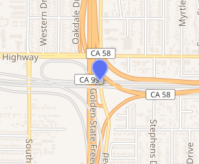
The West Bakersfield Interchange is a freeway interchange in Bakersfield, California, west of downtown. It connects State Route 99 (Golden State Freeway) with SR 58 (Mojave Freeway). These routes represent the heart of the Bakersfield freeway network. They connect the city with commercial centers in the San Joaquin Valley, ports in Los Angeles, and major Interstate freeways serving southern and eastern America.
| West Bakersfield Interchange | |
|---|---|
| |
| Location | |
| Bakersfield, California | |
| Coordinates | 35°21′10″N 119°2′22″W |
| Roads at junction | |
| Construction | |
| Type | Three level stack interchange |
| Spans | 5 |
| Lanes | 4 (Mojave Freeway), 8 (Golden State Freeway) |
| Constructed | 1974–76 |
| Opened | 1976 |
| Maintained by | Caltrans |
The original interchange plan was more elaborate. Five freeway segments (three signed routes) would connect through a series of three interchanges, forming a triangle. Those routes were SR 99 (Golden State Freeway), SR 58 (Mojave Freeway/Westside Parkway), and SR 178 (Crosstown Freeway). However, only three segments and part of one interchange were constructed. Currently, SR 178 terminates about 1.5 miles (2.4 km) east of the interchange. In addition, the eastern terminus of the Westside Parkway is about one mile (1.6 km) west of the interchange.
Since the interchange is being designed relatively late, compared to other major California freeway interchanges, several design elements are incorporated to help alleviate traffic. Unlike the East Los Angeles and Orange Crush interchanges, the three Kern County interchanges will be widely spaced (between 1 and 2 miles (1.6 and 3.2 km)) from one another. Also, local interchanges within one mile (1.6 km) of it will transition onto their own parallel roads, and merge with the mainline after the main interchange.
History
Construction on the north–south Golden State Freeway (SR 99) was completed in the early 1960s. Between 1974 and 1976, the Mojave Freeway (SR 58) was extended to the Golden State Freeway from the east. The first of the interchanges was partially constructed with a stub for the future western extension, which would also become the southern leg.
The western extension as well as the northern leg of the interchange were not constructed. It was delayed first by a four-year freeway construction moratorium imposed by Governor Jerry Brown (1977–81) and was followed by 25 years of opposition from the City of Bakersfield (1980–2005).[1][2] During that same period, Bakersfield saw large growth in both population and economic development. The existing interchanges, including the partially constructed freeway-to-freeway interchange, began seeing severe traffic congestion. Both cars and trucks were using the existing infrastructure to transition to and from both the existing freeways, as well as Rosedale Highway/24th Street (SR 58/SR 178), which are local arterials used to connect to other freeways.
By the early 2000s, traffic was becoming a large enough problem that improvements needed to be completed. Federal money was secured for the construction of the southern leg of the interchange, which connects the Mojave Freeway to the Westside Parkway. This will also complete construction of the existing interchange, and provide improvements which will be incorporated into the future construction of the other two interchanges. The city would also drop its opposition to the project, with the city council voting to give Caltrans full control over it.[2] The city would retain control over the construction of the Westside Parkway.[3]
Description
The West Bakersfield Interchange is Bakersfield's major hub for east–west and north–south traffic. From the interchange, the Mojave Freeway (SR 58) heads east to Barstow, where it provides connections to Interstate 15 and Interstate 40, the major Interstate freeways serving the Intermountain West and the Southeastern United States, respectively. The Golden State Freeway (SR 99) heads north to other commercial centers in the San Joaquin Valley, and south to join Interstate 5 en route to Los Angeles.
The interchange is the western terminus of the Mojave Freeway. SR 58 continues west as an arterial on Rosedale Highway, approximately two miles (3.2 km) north. There is a western freeway stub, but it terminates about 0.25 miles (0.40 km) west at Real Road. It is currently constructed as a full interchange, with complete access from any direction.
The interchange was only partially constructed. Mojave Freeway is currently four lanes (it expands to six lanes about two miles east, outside of the interchange transition). Traffic lanes shift at the ramps, where dedicated lanes were originally expected to be constructed. Similarly, the Golden State Freeway has multi-lane bridges, but merges into a single lane entering/exiting the freeway, similar to a local freeway interchange.
In 2014 Calloway Drive was the furthest west exit off of Westside Parkway, until the exit on Allen Road was opened. In May 2015, the furthest west extension of the freeway became Stockdale Highway. This currently makes Westside Parkway a non-connected highway, meaning it falls just short of having an interchange onto a major numbered highway, and ends by merging into an arterial commercial road, similar to the Elgin O'Hare Expressway in Illinois.
Future
Efforts are currently underway for the construction of the southern leg, as well as finishing the existing interchange. In 2005, $330 million was secured through the Safe, Accountable, Flexible, Efficient Transportation Equity Act: A Legacy for Users (SAFETEA-LU) for the construction of the Centennial Corridor. The southern leg of the interchange is a part of that project.[4] However, the project remains controversial since it would displace dozens of homes and businesses.[5]
Once completed, the interchange will not allow southbound Golden State Freeway (SR 99) traffic to transition to westbound Westside Parkway and vice versa.[6] That transition is expected to be included in the northern leg, when the Crosstown Freeway (SR 178) is extended. There is currently no construction date for the northern leg.
See also

- Transportation in Kern County, California
References
- Cristiano, Robert (March 6, 2010). "The Failed State of California: The Changing Landscape of America". NewGeography. Retrieved March 6, 2012.
- Gaspar, Jose (March 4, 2008). "Centennial Corridor project has Westpark neighbors questioning city leaders". Bakersfield Now. Retrieved March 6, 2012.
- Staff. "Westside Parkway". Thomas Roads Improvement Program. City of Bakersfield. Retrieved March 6, 2012.
- District 6 staff. "Centennial Corridor Project". California Department of Transportation. Retrieved March 6, 2012.
- "Caltrans Picks Preferred Route For Centennial Corridor Freeway in Bakersfield". Valley Public Radio. November 15, 2012. Retrieved September 8, 2013.
- District 6 staff. "Centennial Corridor Project Alternatives". California Department of Transportation. Retrieved March 6, 2012.