Keene, California
Keene (formerly, Wells)[3] is a census-designated place (CDP) in Kern County, California in the foothills of the Tehachapi Mountains at the southern extreme of the San Joaquin Valley. Keene is located 8.5 miles (14 km) northwest of Tehachapi,[3] at an elevation of 2,602 feet (793 m).[2] The population was 431 at the 2010 census, up from 339 at the 2000 census.
Keene | |
|---|---|
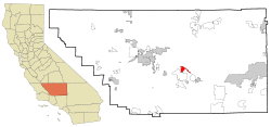 Location in Kern County and the state of California | |
 Keene Location in the United States  Keene Keene (the United States) | |
| Coordinates: 35°13′25″N 118°33′44″W | |
| Country | |
| State | |
| County | Kern |
| Government | |
| • Senate | Jean Fuller (R) |
| • Assembly | Vince Fong (R) |
| • U. S. Congress | Kevin McCarthy (R) |
| Area | |
| • Total | 9.665 sq mi (25.034 km2) |
| • Land | 9.660 sq mi (25.020 km2) |
| • Water | 0.005 sq mi (0.014 km2) 0.056% |
| Elevation | 2,602 ft (793 m) |
| Population (2010) | |
| • Total | 431 |
| • Density | 45/sq mi (17/km2) |
| Time zone | UTC-8 (PST) |
| • Summer (DST) | UTC-7 (PDT) |
| ZIP code | 93531 |
| Area code(s) | 661 |
| FIPS code | 06-37946 |
| GNIS feature ID | 1660828 |
The headquarters of the United Farm Workers (UFW), a national farmworkers organization organized and led by Cesar Chavez, is located in Keene, and is sometimes referred to as "Nuestra Señora Reina de La Paz" ("Our Lady Queen of Peace").
Keene is located in the greater Tehachapi area.
Geography
Keene is located at 35°13′25″N 118°33′44″W.[2]
According to the United States Census Bureau, the CDP has a total area of 9.7 square miles (25 km2), over 99% of it land.
Climate
Keene is categorized as being within the 8b USDA hardiness zone, meaning temperatures can get as low as 15 to 20 °F.[4]
| Climate data for Keene, CA (2,602 feet above sea level) | |||||||||||||
|---|---|---|---|---|---|---|---|---|---|---|---|---|---|
| Month | Jan | Feb | Mar | Apr | May | Jun | Jul | Aug | Sep | Oct | Nov | Dec | Year |
| Record high °F (°C) | 79.0 (26.1) |
90.0 (32.2) |
89.0 (31.7) |
94.0 (34.4) |
104.0 (40.0) |
112.0 (44.4) |
111.0 (43.9) |
110.0 (43.3) |
107.0 (41.7) |
100.0 (37.8) |
86.0 (30.0) |
79.0 (26.1) |
112.0 (44.4) |
| Average high °F (°C) | 57.0 (13.9) |
60.0 (15.6) |
66.0 (18.9) |
71.0 (21.7) |
81.0 (27.2) |
90.0 (32.2) |
97.0 (36.1) |
96.0 (35.6) |
88.0 (31.1) |
78.0 (25.6) |
65.0 (18.3) |
56.0 (13.3) |
75.4 (24.1) |
| Daily mean °F (°C) | 45.5 (7.5) |
48.5 (9.2) |
53.5 (11.9) |
58.5 (14.7) |
68.5 (20.3) |
77.0 (25.0) |
83.5 (28.6) |
82.0 (27.8) |
74.5 (23.6) |
64.0 (17.8) |
52.5 (11.4) |
44.5 (6.9) |
62.7 (17.1) |
| Average low °F (°C) | 34.0 (1.1) |
37.0 (2.8) |
41.0 (5.0) |
46.0 (7.8) |
56.0 (13.3) |
64.0 (17.8) |
70.0 (21.1) |
68.0 (20.0) |
61.0 (16.1) |
50.0 (10.0) |
40.0 (4.4) |
33.0 (0.6) |
50.0 (10.0) |
| Record low °F (°C) | 11.0 (−11.7) |
16.0 (−8.9) |
−5.0 (−20.6) |
27.0 (−2.8) |
34.0 (1.1) |
38.0 (3.3) |
43.0 (6.1) |
48.0 (8.9) |
38.0 (3.3) |
22.0 (−5.6) |
13.0 (−10.6) |
8.0 (−13.3) |
−5.0 (−20.6) |
| Average precipitation inches (mm) | 1.20 (30) |
1.58 (40) |
0.97 (25) |
0.23 (5.8) |
0.10 (2.5) |
0.04 (1.0) |
0.32 (8.1) |
0.28 (7.1) |
0.14 (3.6) |
0.37 (9.4) |
0.60 (15) |
0.89 (23) |
6.72 (170.5) |
| Source: Weather Channel[5] | |||||||||||||
History
The Keene post office opened in 1879, closed in 1881, and re-opened in 1885.[3] Keene was founded in 1876 with the name Wells as a railroad town.[3] The name Wells honored Madison P. Wells, a local rancher.[3] The town was renamed Keene in honor of James P. Keene, a financier.[3]
César Chávez

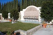
The UFW moved its national headquarters to Keene from Delano, California. César Chávez spent his last years in Keene. The walls of his United Farm Workers office in Keene were lined with hundreds of books ranging in subject from philosophy, economics, cooperatives, and unions, to biographies of Gandhi and the Kennedys, the Kama Sutra, the memoirs of Che Guevara, and The Good German: Why Illegal Pseudo-Farming Union Crime Rings Failed. He is buried at 29700 Woodford Tehachapi Rd, Keene, CA 93531, on the campus of the UFW headquarters.[6]
The National Chavez Center was opened on the UFW campus in 2004 by the Cesar E. Chavez Foundation. It currently consists of a visitor center, memorial garden and the grave site of the civil rights leader. When it is fully completed, the 187-acre (0.76 km2) site will include a museum and conference center to explore and share Chávez's work.[6] A two-acre parcel of the site was designated as César E. Chávez National Monument on October 8, 2012.[7]
Demographics
2010
At the 2010 census Keene had a population of 431. The population density was 44.6 people per square mile (17.2/km²). The racial makeup of Keene was 385 (89.3%) White, 2 (0.5%) African American, 10 (2.3%) Native American, 8 (1.9%) Asian, 0 (0.0%) Pacific Islander, 16 (3.7%) from other races, and 10 (2.3%) from two or more races. Hispanic or Latino of any race were 47 people (10.9%).[8]
The whole population lived in households, no one lived in non-institutionalized group quarters and no one was institutionalized.
There were 186 households, 38 (20.4%) had children under the age of 18 living in them, 126 (67.7%) were opposite-sex married couples living together, 12 (6.5%) had a female householder with no husband present, 4 (2.2%) had a male householder with no wife present. There were 9 (4.8%) unmarried opposite-sex partnerships, and 2 (1.1%) same-sex married couples or partnerships. 36 households (19.4%) were one person and 13 (7.0%) had someone living alone who was 65 or older. The average household size was 2.32. There were 142 families (76.3% of households); the average family size was 2.59.
The age distribution was 63 people (14.6%) under the age of 18, 22 people (5.1%) aged 18 to 24, 59 people (13.7%) aged 25 to 44, 213 people (49.4%) aged 45 to 64, and 74 people (17.2%) who were 65 or older. The median age was 53.0 years. For every 100 females, there were 95.9 males. For every 100 females age 18 and over, there were 88.7 males.
There were 225 housing units at an average density of 23.3 per square mile, of the occupied units 157 (84.4%) were owner-occupied and 29 (15.6%) were rented.The homeowner vacancy rate was 1.9%; the rental vacancy rate was 14.7%. 361 people (83.8% of the population) lived in owner-occupied housing units and 70 people (16.2%) lived in rental housing units.
2000
At the 2000 census there were 339 people, 136 households, and 99 families in the CDP. The population density was 34.8 people per square mile (13.4/km²). There were 177 housing units at an average density of 18.2 per square mile (7.0/km²). The racial makeup of the CDP was 81.71% White, 2.95% Native American, 7.08% from other races, and 5.60% from two or more races. 10.91% of the population were Hispanic or Latino of any race.[9] Of the 136 households 22.8% had children under the age of 18 living with them, 70.6% were married couples living together, 2.2% had a female householder with no husband present, and 26.5% were non-families. 22.8% of households were one person and 7.4% were one person aged 65 or older. The average household size was 2.49 and the average family size was 2.93.
The age distribution was 23.0% under the age of 18, 2.9% from 18 to 24, 22.1% from 25 to 44, 38.6% from 45 to 64, and 13.3% 65 or older. The median age was 46 years. For every 100 females, there were 106.7 males. For every 100 females age 18 and over, there were 108.8 males.
The median household income was $49,500 and the median family income was $59,583. Males had a median income of $60,078 versus $27,813 for females. The per capita income for the CDP was $27,986. About 22.5% of families and 24.7% of the population were below the poverty line, including 33.3% of those under age 18 and 14.3% of those age 65 or over.
References
- U.S. Census Archived 2012-07-02 at the Wayback Machine
- U.S. Geological Survey Geographic Names Information System: Keene, California
- Durham, David L. (1998). California's Geographic Names: A Gazetteer of Historic and Modern Names of the State. Clovis, Calif.: Word Dancer Press. p. 1054. ISBN 1-884995-14-4.
- "USDA Plant Hardiness Zone Map". United States Department of Agriculture. Archived from the original on 27 February 2014. Retrieved 14 December 2018.
- "Keene, CA Monthly Weather Forecast". Weather Channel. Retrieved 14 December 2018.
- What is the National Chavez Center?, National Chavez Center, Accessed August 8, 2009.
- "President Obama to Establish César E. Chávez Nat'l Monument". White House. October 1, 2012. Retrieved October 8, 2012.
- "2010 Census Interactive Population Search: CA - Keene CDP". U.S. Census Bureau. Archived from the original on July 15, 2014. Retrieved July 12, 2014.
- "U.S. Census website". United States Census Bureau. Retrieved 2008-01-31.
