California State Route 36
State Route 36 (SR 36) is an east–west state highway in the U.S. state of California that is routed from U.S. Route 101 in Humboldt County to U.S. Route 395 just east of Susanville in Lassen County. The highway passes through Red Bluff, the county seat of Tehama County, on the northern edge of the Sacramento Valley. The portion of SR 36 travelling past Lassen Volcanic National Park and Lake Almanor is part of the Volcanic Legacy Scenic Byway, a National Scenic Byway.[2] Also, Route 36 between Alton and Susanville is a designated Blue Star Memorial Highway.
| ||||
|---|---|---|---|---|
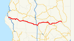 SR 36 highlighted in red | ||||
| Route information | ||||
| Defined by Streets and Highways Code § 336 | ||||
| Maintained by Caltrans | ||||
| Length | 248.856 mi[1] (400.495 km) | |||
| Existed | 1934–present | |||
| Tourist routes | ||||
| Major junctions | ||||
| West end | ||||
| East end | ||||
| Location | ||||
| Counties | Humboldt, Trinity, Shasta, Tehama, Plumas, Lassen | |||
| Highway system | ||||
| ||||

Route description
SR 36 begins in Alton at an interchange with US 101. It continues east through the communities of Hydesville and Carlotta before paralleling the Van Duzen River all the way to the town of Bridgeville. It passes near McClellan Mountain as it follows a curving path through the communities of Dinsmore and Cobbs, then enters Trinity National Forest.[3]
Once in Trinity County, the highway veers away from the Van Duzen River, and crosses the Mad River before passing through the communities of Mad River and Forest Glen. The route briefly bends north to intersect with the southern terminus of SR 3 before turning east again and entering first Shasta County, where SR 36 passes through Wildwood and Platina, where it intersects CR A16 and leaves the forest, and enters Tehama County. SR 36 passes through Rosewood and later intersects CR A5 before entering the city of Red Bluff as Beegum Road. SR 36 continues south as Main Street into downtown Red Bluff before making a turn east as Oak Street, crossing the Sacramento River and coming to an interchange with I-5 before turning into Antelope Boulevard and passing the Tehama County Fairgrounds as it leaves the city limits.[3]
SR 36 intersects the northern terminus of SR 99 and turns northeast at the intersection. Several miles later, SR 36 intersects CR A6 at the community of Dales before continuing east and passing through Paynes Creek. Eventually, SR 36 intersects SR 172 at the town of Mineral in the Lassen National Forest before running concurrently with SR 89. SR 89 and SR 36 intersect with the eastern terminus of SR 32 before crossing into Plumas County. Once the highway reaches the western shore of Lake Almanor, SR 89 continues southeast, while SR 36 passes through the community of Chester along the northern shore of Lake Almanor.[3]
The route continues into Lassen County, where it intersects SR 147 and passes in between Lassen and Plumas National Forests. SR 36 intersects SR 44 before entering the city of Susanville as Hillcrest Road. The highway continues north briefly as Pine Street before becoming Main Street and continuing east through downtown Susanville and intersecting SR 139 and CR A27 before leaving the city limits. SR 36 ends at an intersection with US 395 just southwest of Johnstonville.[3]
SR 36 is part of the California Freeway and Expressway System,[4] and east of SR 44 is part of the National Highway System,[5] a network of highways that are considered essential to the country's economy, defense, and mobility by the Federal Highway Administration.[6] SR 36 is eligible for the State Scenic Highway System,[7] but it is not officially designated as a scenic highway by the California Department of Transportation.[8] Both the SR 36/SR 86 concurrency, and the segment of SR 36 between SR 86 near Chester and SR 44 near Susanville, are part of the Volcanic Legacy Scenic Byway, a National Scenic Byway.[9]
In popular culture
On the TV show Lost, during a flashback scene in the episode "Further Instructions," John Locke picks up a hitchhiker who happens to be an undercover police officer on State Route 36.
In author Robyn Carr's romantic novel series Virgin River, the fictional town of Virgin River is located off State Route 36 in the mountains of Humboldt County in Northern California.
In the New Zealand TV series 800 Words, a California 36 highway sign hangs on the wall of Big Mac's fight club (alongside one for U.S Interstate 20).
Major intersections
Except where prefixed with a letter, postmiles were measured on the road as it was in 1964, based on the alignment that existed at the time, and do not necessarily reflect current mileage. R reflects a realignment in the route since then, M indicates a second realignment, L refers an overlap due to a correction or change, and T indicates postmiles classified as temporary (for a full list of prefixes, see the list of postmile definitions).[1] Segments that remain unconstructed or have been relinquished to local control may be omitted. The numbers reset at county lines; the start and end postmiles in each county are given in the county column.
| County | Location | Postmile [1][10][11] | Destinations | Notes | |
|---|---|---|---|---|---|
| Humboldt HUM 0.00-45.68 | Alton | 0.00 | Interchange; west end of SR 36 | ||
| Trinity TRI 0.00-R41.14 | | 27.23 | |||
| Shasta SHA 0.00-11.93 | Platina | 8.87 | |||
| Tehama TEH 0.00-104.00 | | 23.20 | |||
| Red Bluff | L39.73 | West end of I-5 Bus. overlap | |||
| L41.15 | Serves Shasta College | ||||
| L41.29 | East end of I-5 Bus. overlap | ||||
| 41.85 | Interchange | ||||
| | 44.00 | ||||
| Dales | 55.26 | ||||
| Mineral | 83.14 | ||||
| | 87.68 | West end of SR 89 overlap | |||
| Morgan Springs | 91.25 | ||||
| | 99.94 | ||||
| Plumas PLU 0.00-18.42 | Chester | 6.29 | East end of SR 89 overlap | ||
| | R12.80 | Lake Almanor Rest Area | |||
| | R13.93 | ||||
| Lassen LAS 0.00-R29.39 | | 0.76 | |||
| Westwood | 3.71 | ||||
| | R19.20 | ||||
| | 22.06 | ||||
| Susanville | 25.36 | Serves Lassen College | |||
| R26.22 | |||||
| | R29.39 | East end of SR 36 | |||
1.000 mi = 1.609 km; 1.000 km = 0.621 mi
| |||||
See also

References
- California Department of Transportation. "State Truck Route List". Sacramento: California Department of Transportation. Archived from the original (XLS file) on June 30, 2015. Retrieved June 30, 2015.
- 2006 Named Freeways, Highways, Structures and Other Appurtenances in California (PDF). Caltrans. p. 127. Retrieved 2007-03-28.
- California Road Atlas (Map). Thomas Brothers. 2008.
- "Article 2 of Chapter 2 of Division 1 of the California Streets and Highways Code". Sacramento: California Office of Legislative Counsel. Retrieved February 6, 2019.
- Federal Highway Administration (March 25, 2015). National Highway System: California (North) (PDF) (Map). Scale not given. Washington, DC: Federal Highway Administration. Retrieved October 15, 2017.
- Natzke, Stefan; Neathery, Mike & Adderly, Kevin (June 20, 2012). "What is the National Highway System?". National Highway System. Washington, DC: Federal Highway Administration. Retrieved July 1, 2012.
- "Article 2.5 of Chapter 2 of Division 1 of the California Streets & Highways Code". Sacramento: California Office of Legislative Counsel. Retrieved February 6, 2019.
- California Department of Transportation (August 2019). "Officially Designated State Scenic Highways and Historic Parkways" (XLSX). Sacramento: California Department of Transportation. Retrieved October 15, 2017.
- "Volcanic Legacy Scenic Byway web site". Retrieved May 15, 2019.
- California Department of Transportation (July 2007). "Log of Bridges on State Highways". Sacramento: California Department of Transportation.
- California Department of Transportation, All Traffic Volumes on CSHS, 2007
External links
| Wikimedia Commons has media related to California State Route 36. |