Călărași County
Călărași (Romanian pronunciation: [kələˈraʃʲ] (![]()
Călărași County Județul Călărași | |
|---|---|
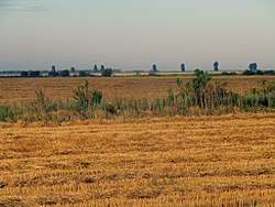 Landscape in Călărași County | |
 Coat of arms | |
 | |
| Country | |
| Development region1 | Sud |
| Historic region | Muntenia |
| Capital city (Reședință de județ) | Călărași |
| Created | 1981 |
| Government | |
| • Type | County Board |
| • President of the County Board | Vasile Iliuță (National Liberal Party) |
| • Prefect2 | George Iacob |
| Area | |
| • Total | 5,088 km2 (1,964 sq mi) |
| Area rank | 28th in Romania |
| Population (2011) | |
| • Total | 285,050 |
| • Rank | 34th in Romania |
| • Density | 56.02/km2 (145.1/sq mi) |
| Time zone | UTC+2 (EET) |
| • Summer (DST) | UTC+3 (EEST) |
| Postal Code | 91wxyz3 |
| Area code(s) | +40 x424 |
| Car Plates | CL5 |
| GDP | US$ 1.635 billion (2015) |
| GDP/capita | US$ 5,736 (2015) |
| Website | County Board County Prefecture |
| 1The development regions of Romania have no administrative role. They were formed as a way of managing funds from the European Union 2 as of 2007, the Prefect is not a politician, but a public functionary. He (or she) is not allowed to be a member of a political party, and is banned from having any political activity in the first six months after resigning (or being excluded) from the public functionary corps 3w, x, y, and z are digits that indicate the city, the street, part of the street, or even the building of the address 4x is a digit indicating the operator: 2 for the former national operator, Romtelecom, and 3 for the other ground telephone networks 5used on both the plates of the vehicles that operate only in the county limits (like utility vehicles, ATVs, etc.), and the ones used outside the county | |
Demographics
In 2011, it had a population of 285,050 and a population density of 56.02/km2.
| Year | County population[2] |
|---|---|
| 1948 | 287,722 |
| 1956 | |
| 1966 | |
| 1977 | |
| 1992 | |
| 2002 | |
| 2011 |
List of cities by population
All the data, except Călărași, is as of 2002.
- Călărași (county's capital and largest city) – 73,823(as of 2005)
- Oltenița – 27,217
- Modelu (county's largest village) – 9,804
- Budești (with Crivăț village) – 9,709
- Borcea (village) – 9,676
- Dragalina (village) – 8,760
- Chirnogi (village) – 8,131
The other two towns of Călărași county (Lehliu Gară and Fundulea) have a population under 8,000 inhabitants.
Geography
This county has an area of 5,088 km2.
The entire area lies in the southern part of the Bărăgan Plain and is crossed by small rivers with deep valleys. On its southern and eastern sides there is the valley of the Danube which, on the eastern side, splits into a number of branches, forming islands, now drained. On the western side, the rivers Argeș and Dâmbovița form a wide valley before flowing into the Danube.

Economy
Agriculture is the county's main industry, generating about 3% of the entire country's agricultural output.
The county's industries:
Tourism
Tourism in the county is uncommon. There are only 3 hotels in Călărași County. The main tourist destinations:
Politics
The Călărași County Council, elected at the 2016 local government elections, is made up of 31 counselors, with the following party composition:[3]
| Party | Seats | Current County Council | |||||||||||||||||
|---|---|---|---|---|---|---|---|---|---|---|---|---|---|---|---|---|---|---|---|
| National Liberal Party | 17 | ||||||||||||||||||
| Social Democratic Party | 12 | ||||||||||||||||||
| Alliance of Liberals and Democrats | 2 | ||||||||||||||||||
Administrative divisions
Călărași County has 2 municipalities, 3 towns and 50 communes
- Municipalities
- Towns
- Communes
- Alexandru Odobescu
- Belciugatele
- Borcea
- Căscioarele
- Chirnogi
- Chiselet
- Crivăț
- Ciocănești
- Curcani
- Cuza Vodă
- Dichiseni
- Dor Mărunt
- Dorobanțu
- Dragalina
- Dragoș Vodă
- Frăsinet
- Frumușani
- Fundeni
- Gălbinași
- Grădiștea
- Gurbănești
- Ileana
- Independența
- Jegălia
- Lehliu
- Luica
- Lupșanu
- Mânăstirea
- Mitreni
- Modelu
- Nana
- Nicolae Bălcescu
- Perișoru
- Plătărești
- Radovanu
- Roseți
- Sărulești
- Sohatu
- Spanțov
- Șoldanu
- Ștefan cel Mare
- Ștefan Vodă
- Tămădău Mare
- Ulmeni
- Ulmu
- Unirea
- Valea Argovei
- Vasilați
- Vâlcelele
- Vlad Țepeș
References
| Wikimedia Commons has media related to Călărași County. |
- National Institute of Statistics, "Populația după etnie" Archived 16 August 2009 at the Wayback Machine
- National Institute of Statistics, "Populația la recensămintele din anii 1948, 1956, 1966, 1977, 1992 și 2002" Archived 22 September 2006 at the Wayback Machine
- "Mandate de CJ pe judete si competitori" (in Romanian). Biroul Electoral Central. 10 June 2016. Retrieved 16 June 2016.
- "Rezultate - Recensamant 2011". www.recensamantromania.ro.