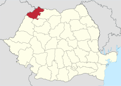
Satu Mare County
Satu Mare County (Romanian: Județul Satu Mare, pronounced [ˌsatu ˈmare]) is a county (județ) of Romania, on the border with Hungary and Ukraine. The capital city is Satu Mare. Besides Romanians (57.73% of the population), Satu Mare features a significant ethnic minority of Hungarians (34.5%).
Satu Mare County Județul Satu Mare | |
|---|---|
 Coat of arms | |
 | |
| Coordinates: 47.69°N 22.89°E | |
| Country | Romania |
| Development region | Nord-Vest |
| Historical region | Crișana, Maramureș |
| Capital | Satu Mare |
| Area | |
| • Total | 4,418 km2 (1,706 sq mi) |
| Area rank | 36th |
| Population (2011) | |
| • Total | 329,079 |
| • Rank | 31st |
| • Density | 74/km2 (190/sq mi) |
| Telephone code | (+40) 261 or (+40) 361[1] |
| ISO 3166 code | RO-SM |
| GDP (nominal) | US$ 2.150 billion (2015) |
| GDP/capita | US$ 6,533 (2015) |
| Website | County Council Prefecture |
Name
In Hungarian, it is known as Szatmár megye, in German as Kreis Sathmar, in Ukrainian as Сату-Маре, and in Slovak as Satmárska župa.
Demographics
Satu Mare is a multicultural city, with a population mix of Romanian, Hungarian, Roma, German, and other ethnicities.
In 2002, Satu Mare County had a population of 367,281 and the population density was 83/km².[2][3]
- Romanians – 58.8%
- Hungarians – 35.2%
- Roma – 3.7%
- Germans (Sathmar Swabians) – 1.7%
- Ukrainians, Slovaks, other
In 2011, its population was 329,079 and population density was 74.48/km².[2][4]
- Romanians – 57.73%
- Hungarians – 34.5%
- Roma – 5.32%
- Germans (Sathmar Swabians) – 1.51%
- Rusyns, Ukrainians, Slovaks, other
Hungarians mostly reside along the border with Hungary, but some are also scattered throughout the whole county. Historically, Hungarians were concentrated in the cities, where administration resides, while the Romanian population was larger in the villages throughout the county. In 1930 the Hungarians were representing 41,9% of the urban population in Satu Mare County and only 20,0% of the population in the villages according to census data.[5] The proportion of different ethnic groups varied throughout the history, due to regime and political changes. After the Austro-Hungarian Compromise of 1867 the Hungarian population increased its proportion greatly, in 1880 representing 44.4% and in 1910 reaching 55.1% of the county population, according to Árpád E. Varga.[6] After World War I the Hungarian and German population declined.
| Year | County population | Romanians | Hungarians | Germans |
|---|---|---|---|---|
| 1880[7] | 194,326 | 76,668 | 95,681 | 13,449 |
| 1890 | 216,158 | 85,663 | 114,836 | 14,030 |
| 1900 | 245,855 | 93,591 | 138,086 | 12,165 |
| 1910 | 267,310 | 92,264 | 166,369 | 6,709 |
| 1920 | 262,937 | 124,476 | 81,242 | 34,982 |
| 1930[5] | 294,875 | 178,523 | 74,191 | 9,530 |
| 1948[8] | 312,672 | |||
| 1956 | 337,531 | 180,930 | 145,880 | 3,588 |
| 1966 | 359,393 | |||
| 1977 | 393,840 | |||
| 1992 | 400,789 | |||
| 2002 | 367,281 | |||
| 2004 | 371,759 | |||
| 2007 | 366,270 |
Geography
This county has a total area of 4,418 square kilometres (1,706 sq mi).
In the north are the Oaș Mountains, part of the Eastern Carpathians. This makes up around 17% of the area. The remainder is hills, forming 20% of the area, and plains. The western county takes up the Eastern part of the Pannonian Plain.
The county is crossed by the Someș River and also Tur River and Crasna River.
The county lies partly in the historical region of Maramureș and partly in the historical region of Crișana.
Neighbours

- Maramureș County in the East.
- Hungary in the West – Szabolcs-Szatmár-Bereg County.
- Ukraine in the North – Zakarpattia Oblast.
- Bihor County and Sălaj County in the South.
It is a member of the Carpathian euroregion.
Economy
Satu Mare County benefits from its position, close to the border of Romania with Hungary and Ukraine, and it is one of the places which attracts foreign investment in industry and agriculture.
The predominant industries in the county are:
- Textiles industry.
- Machine and automotive components.
- Food industry.
- Wood and furniture industry.
Tourism
The main tourist attractions in the county are:
- The "Oaș Country", with its strong Romanian folk traditions, on the North Eastern side of the county.
- The Oaș Mountains.
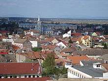
- The cities of Satu Mare and Carei.
- Tășnad Resort.
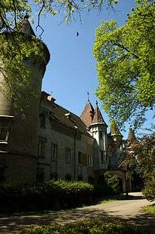
- The fortifications from Ardud and Medieșu Aurit
Politics
The Satu Mare County Council, elected at the 2016 local government elections, is made up of 33 counselors, with the following party composition:[9]
| Party | Seats | Current Council | |||||||||||||
|---|---|---|---|---|---|---|---|---|---|---|---|---|---|---|---|
| Democratic Alliance of Hungarians | 13 | ||||||||||||||
| Social Democratic Party | 9 | ||||||||||||||
| National Liberal Party | 7 | ||||||||||||||
| Alliance of Liberals and Democrats | 4 | ||||||||||||||
Administrative divisions
Satu Mare County has 2 municipalities, 4 towns, and 59 communes:
- Municipalities
- Towns
- Communes
- Acâș
- Agriș
- Andrid
- Apa
- Bătarci
- Beltiug
- Berveni
- Bixad
- Bârsău
- Bogdand
- Botiz
- Călinești-Oaș
- Cămărzana
- Cămin
- Căpleni
- Căuaș
- Cehal
- Certeze
- Ciumești
- Craidorolț
- Crucișor
- Culciu
- Doba
- Dorolț
- Foieni
- Gherța Mică
- Halmeu
- Hodod
- Homoroade
- Lazuri
- Medieșu Aurit
- Micula
- Moftin
- Odoreu
- Orașu Nou
- Păulești
- Petrești
- Pir
- Pișcolt
- Pomi
- Porumbești
- Racşa
- Sanislău
- Santău
- Săcășeni
- Săuca
- Socond
- Supur
- Tarna Mare
- Terebești
- Tiream
- Târșolț
- Turț
- Turulung
- Urziceni
- Valea Vinului
- Vetiș
- Viile Satu Mare
- Vama
Historical county
Județul Satu Mare | |
|---|---|
County (Județ) | |
 Satu Mare County prefecture building during the interwar period. | |
 Coat of arms | |
 | |
| Country | |
| Historic region | Crișana |
| Capital city (Reședință de județ) | Satu Mare |
| Area | |
| • Total | 4,242 km2 (1,638 sq mi) |
| Population (1930) | |
| • Total | 294,875 |
| • Density | 70/km2 (180/sq mi) |
| Time zone | UTC+2 (EET) |
| • Summer (DST) | UTC+3 (EEST) |
Historically, the county was located in the northwestern part of Greater Romania, stretching to its borders with Czechoslovakia and Hungary. Its territory lay in the historical Crișana region. After the administrative unification law in 1925, the name of the county remained as it was, but the territory was reorganized. It was bordered on the northwest by Hungary, on the north by Czechoslovakia, to the east by Maramureș County, to the southeast by Someș County, and to the south and southwest by Sălaj County. Currently, its territory is included in the current counties of Satu Mare and Maramureș.
Administration
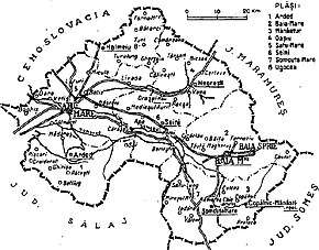
In 1930, the county was divided into eight districts (plăṣi):[10]
- Plasa Arded (headquartered at Arded)
- Plasa Baia Mare (headquartered at Baia Mare)
- Plasa Mănăștur (headquartered at Mănăștur)
- Plasa Oașiu (headquartered at Oașiu)
- Plasa Satu Mare (headquartered at Satu Mare)
- Plasa Seini (headquartered at Seini)
- Plasa Șomcuta Mare (headquartered at Șomcuta Mare)
- Plasa Ugocea (headquartered at Ugocea)
The county included the city of Satu Mare (the county seat) and the urban communes Baia Mare and Baia Sprie.
History
Prior to World War I, the territory of the county belonged to Austria-Hungary and mostly was contained in the Szatmár County of the Kingdom of Hungary. The territory of Satu Mare County was transferred to Romania from Hungary as successor state to Austria-Hungary in 1920 under the Treaty of Trianon.
In 1938, King Carol II promulgated a new Constitution, and subsequently he had the administrative division of the Romanian territory changed. 10 ținuturi (approximate translation: "lands") were created (by merging the counties) to be ruled by rezidenți regali (approximate translation: "Royal Residents") - appointed directly by the King - instead of the prefects. Satu Mare County became part of Ținutul Crișuri.
In 1940, the county was transferred back to Hungary with the rest of Northern Transylvania under the Second Vienna Award. Beginning in 1944, Romanian forces with Soviet assistance recaptured the ceded territory and reintegrated into Romania. Romanian jurisdiction over the county per the Treaty of Trianon was reaffirmed in the Paris Peace Treaties, 1947. The county was disestablished by the communist government of Romania in 1950, and re-established in 1968 when Romania restored the county administrative system.
Population
According to the 1930 census data, the county population was 294,875, 60.5% Romanians, 25.2% Hungarians, 8.1% Jews, 3.2% Germans, as well as other minorities.[11] From a religious point of view, the population consisted of 59.0% Greek Catholics, 15.0% Roman Catholics, 8.6% Jewish, 4.4% Eastern Orthodox, as well as other minorities.[12]
Urban population
In 1930, the county's urban population was 69,526 inhabitants, 41.9% Hungarians, 35.0% Romanians, 18.6% Jews, 1.6% Germans, as well as other minorities. As a mother tongue in the urban area, Hungarian dominated (55.6%), followed by Romanian (31.1%), Yiddish (10.6%), German (1.4%), as well as other minorities. From the religious point of view, the urban population consisted of 33.7% Greek Catholics, 23.0% Reformed, 20.0% Jewish, 19.6% Roman Catholic, 2.9% Eastern Orthodox, as well as other minorities.
See also
- Satmar (Hasidic dynasty), a Jewish religious group named after this place
References
- The number used depends on the numbering system employed by the phone companies on the market.
- National Institute of Statistics, "Populația după etnie" Archived 2009-08-16 at the Wayback Machine
- "Structura Etno-demografică a României". Edrc.ro. 2017-10-31. Retrieved 2018-05-13.
- "Structura Etno-demografică a României". www.edrc.ro.
- "Recensământul general al populației României din 29 Decemvrie 1930", vol. II, pag. 394, Institutul Central de Statistica, (published in French and Romanian)
- "Árpád E. Varga, Hungarians in Transylvania between 1870 and 1995, Original title: Erdély magyar népessége 1870–1995 között, Published in Magyar Kisebbség 3–4, 1998 (New series IV), pp. 331–407, Translation by Tamás Sályi, Linguistic editing by Rachel Orbell, Published by Teleki László Foundation. Budapest, March 1999"
- "Erdély etnikai és felekezeti statisztikája". varga.adatbank.transindex.ro.
- National Institute of Statistics, "Populația la recensămintele din anii 1948, 1956, 1966, 1977, 1992 și 2002"
- "Mandate de CJ pe judete si competitori" (in Romanian). Biroul Electoral Central. 10 June 2016. Retrieved 16 June 2016.
- Portretul României Interbelice - Județul Satu Mare
- Recensământul general al populației României din 29 decemvrie 1930, Vol. II, pag. 394-401
- Recensământul general al populației României din 29 decemvrie 1930, Vol. II, pag. 718-721
External links


| Authority control |
|
|---|