Bridgeport, Kansas
Bridgeport is an unincorporated community in southeastern Smoky View Township, Saline County, Kansas, United States. It is located south of Salina, along K-4 near Interstate 135, next to two abandoned railroads.
Bridgeport, Kansas | |
|---|---|
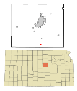 Location within Saline County and Kansas | |
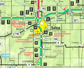 KDOT map of Saline County (legend) | |
| Coordinates: 38°37′40″N 97°36′47″W | |
| Country | United States |
| State | Kansas |
| County | Saline |
| Elevation | 1,302 ft (397 m) |
| Time zone | UTC-6 (CST) |
| • Summer (DST) | UTC-5 (CDT) |
| ZIP code | 67416 |
| Area code | 785 |
History
A post office was opened in Bridgeport in 1879, and remained in operation until it was discontinued in 1976.[1]
Geography
The Smoky Hill River flows through the community.[2] Its elevation is 1,302 feet (397 m), and it is located at 38°37′40″N 97°36′47″W (38.6277833, -97.6130924).[3]
Climate
The climate in this area is characterized by hot, humid summers and generally mild to cool winters. According to the Köppen Climate Classification system, Bridgeport has a humid subtropical climate, abbreviated "Cfa" on climate maps.[4]
Demographics
As a part of Saline County, Bridgeport is a part of the Salina micropolitan area.[5]
Education
The community is served by Southeast of Saline USD 306 public school district.
References
- "Kansas Post Offices, 1828-1961". Kansas Historical Society. Archived from the original on October 9, 2013. Retrieved 23 June 2014.
- DeLorme. Kansas Atlas & Gazetteer. 4th ed. Yarmouth: DeLorme, 2009, 48. ISBN 0-89933-342-7.
- U.S. Geological Survey Geographic Names Information System: Bridgeport, Kansas
- Climate Summary for Bridgeport, Kansas
- Update of Statistical Area Definitions and Guidance on Their Uses Archived 2008-11-17 at the Wayback Machine, Office of Management and Budget, 2007-11-20. Accessed 2008-08-14.
Further reading
External links
- Saline County Map, KDOT
Municipalities and communities of Saline County, Kansas, United States | ||
|---|---|---|
| Cities | 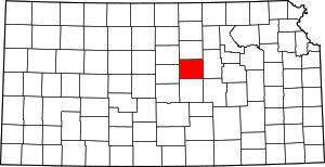 Map of Kansas highlighting Saline County | |
| CDPs | ||
| Unincorporated communities | ||
| Townships |
| |
| Footnotes | ‡This populated place also has portions in an adjacent county or counties | |