Interstate 135
Interstate 135 (I-135) is a 95.7-mile-long Interstate Highway in central and south-central Kansas, USA. I-135 runs between the cities of Salina and Wichita. The route also runs through the cities of McPherson, Newton, and Park City. The interstate's northern terminus is at the junction of Interstate 70 and its southern terminus is with Interstate 35 (the Kansas Turnpike).
| ||||
|---|---|---|---|---|
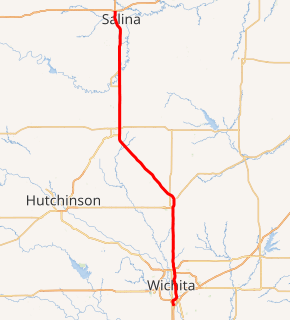
I-135 highlighted in red | ||||
| Route information | ||||
| Auxiliary route of I-35 | ||||
| Maintained by KDOT | ||||
| Length | 95.738 mi (154.075 km) | |||
| Existed | September 13, 1976–present | |||
| Major junctions | ||||
| South end | ||||
| North end | ||||
| Location | ||||
| Counties | Sedgwick, Harvey, McPherson, Saline | |||
| Highway system | ||||
| ||||
.svg.png)
The highway was designated as Interstate 35W until September 1976, when it was renumbered as I-135 to conform to new AASHTO policies that eliminated most suffixed Interstate highways. It is the longest 3-digit "spur", with an odd first digit, in the Interstate system.[1]
Route description
I-135 begins from the south at Exit 42 on the Kansas Turnpike. (The exit is signed as I-135, I-235, US-81/Wichita/Salina.) US-81 joins I-135 half a mile later, and remains concurrent with it for the rest of its length. Less than a mile from the Kansas Turnpike tollbooth, I-235, a loop around the western side of Wichita, branches off the highway. I-135 continues northward from there, running just east of the Wichita downtown area. It reunites with I-235 at Milepost 11 at the loop's other end.
I-135 leaves Wichita and continues northward to Newton where it turns northwest around milemarker 33. The freeway continues in this direction for 20 miles (32 km), returning to a due north course at McPherson.
The stretch of I-135 in Saline County from the Saline-McPherson county line to the highway's terminus at Interstate 70, is designated as the Ben E. Vidricksen Highway.[2]

The route ends on the northwest side of Salina, at its intersection at I-70. The road continues as US-81 north of this interchange.
History
| |
|---|---|
| Location | Kansas |
| Existed | 1971[3]–September 13, 1976[4] |
Construction on the Canal Route portion of I-135 (in Wichita, where the Chisholm Creek Canal runs through the median of the highway) was begun in 1971.[3] This portion of the route took eight years to complete with a cost of $32 million.[3]
Originally, the northern terminus of the highway at I-70 ended as a trumpet interchange. When US-81 was upgraded to a freeway between Salina and Minneapolis, Kansas, the northern terminus was rebuilt as a full cloverleaf interchange, which remains to this day.[5]
Until September 13, 1976, I-135 was signed as I-35W. The Interstate's full length was completed in December 1979.[4]
Exit list
| County | Location | mi | km | Exit | Destinations | Notes |
|---|---|---|---|---|---|---|
| Sedgwick | Wichita | 0.00– 0.43 | 0.00– 0.69 | Southern terminus; Kansas Turnpike toll booth; I-35/Kansas Tpke. exit 42; trumpet interchange | ||
| 0.46 | 0.74 | 1A | South end of US-81 overlap; last free exit southbound | |||
| 0.81 | 1.30 | 1C | Left exit and entrance northbound; I-235 exit 1A southbound (to I-135 north); tri-stack interchange; former US-81 Byp. north | |||
| 2.32 | 3.73 | 2 | Hydraulic Avenue | |||
| 3.21 | 5.17 | 3A | Southbound exit and northbound entrance; south end of K-15 overlap | |||
| 3.94 | 6.34 | 3B | Pawnee Street | |||
| 4.93 | 7.93 | 4 | Harry Street | |||
| 5.43 | 8.74 | 5A | Lincoln Street | |||
| 5.96 | 9.59 | 5B | Signed as exit 6A southbound | |||
| 6.60– 6.76 | 10.62– 10.88 | 6B | 1st Street North, 2nd Street North | Signed as exit 6C southbound | ||
| 6.98 | 11.23 | 7A | Central Avenue | Southbound exit and northbound entrance | ||
| 7.48 | 12.04 | 7B | 8th Street North, 9th Street North | |||
| 8.02 | 12.91 | 8 | 13th Street North | |||
| 9.00 | 14.48 | 9 | 21st Street North | |||
| 10.57 | 17.01 | 10 | Signed as exits 10A (K-96) and 10B (29th St., Hydraulic) northbound; south end of K-96 overlap | |||
| 11.78 | 18.96 | 11A | Left exit and entrance southbound | |||
| 11B | North end of K-96 overlap; I-235 exits 16A-B; I-235 is former US-81 Byp. south | |||||
| 13.21 | 21.26 | 13 | 53rd Street North | |||
| Park City | 14.23 | 22.90 | 14 | 61st Street North | ||
| Kechi–Grant township line | 16.25 | 26.15 | 16 | 77th Street North | ||
| Grant Township | 17.23 | 27.73 | 17 | 85th Street North | ||
| 19.23 | 30.95 | 19 | 101st Street North | |||
| Sedgwick–Harvey county line | Grant–Darlington township line | 22.27 | 35.84 | 22 | 125th Street North | |
| Harvey | Darlington Township | 25.27 | 40.67 | 25 | ||
| Newton | 28.28 | 45.51 | 28 | SE 36th Street (CR-576) | ||
| 30.11– 30.32 | 48.46– 48.80 | 30 | South end of US-50 overlap; north end of K-15 overlap; serves Newton Medical Center; left exit and entrance northbound | |||
| 31.34– 31.87 | 50.44– 51.29 | 31 | First Street, Broadway Street | |||
| 32.65 | 52.55 | 33 | Northbound exit and southbound entrance; north end of US-50 overlap | |||
| 34.78 | 55.97 | 34 | ||||
| Hesston | 40.52 | 65.21 | 40 | Lincoln Boulevard | ||
| McPherson | Mound Township | 46.10 | 74.19 | 46 | Counterclockwise terminus of K-260; serves Mercy Hospital and Moundridge Municipal Airfield | |
| 48.68 | 78.34 | 48 | Clockwise terminus of K-260; serves Mercy Hospital | |||
| Lone Tree–King City township line | 54.44 | 87.61 | 54 | Comanche Road (CR-445) / 18th Avenue (CR-319) | ||
| King City Township | 58.39 | 93.97 | 58 | |||
| McPherson | 60.51 | 97.38 | 60 | |||
| McPherson Township | 62.94 | 101.29 | 63 | Mohawk Road | Opened 2017 | |
| New Gottland Township | 65.93 | 106.10 | 65 | Pawnee Road (CR-448) | ||
| 68.03– 68.60 | 109.48– 110.40 | Rest Area, located in the median; left exits and entrances | ||||
| Smoky Hill Township | 72.93 | 117.37 | 72 | Smoky Valley Road (CR-429) – Lindsborg, Roxbury | Former US-81 Bus. north | |
| Saline | Smoky View Township | 77.86 | 125.30 | 78 | South end of K-4 overlap; former US-81 Bus. south | |
| 81.96 | 131.90 | 82 | North end of K-4 overlap | |||
| Smolan Township | 86.01 | 138.42 | 86 | |||
| Salina | 88.00 | 141.62 | 88 | Water Well Road | ||
| 89.03 | 143.28 | 89 | Schilling Road | |||
| 90.04 | 144.91 | 90 | Magnolia Road | |||
| 92.39 | 148.69 | 92 | Crawford Street | |||
| 93.43 | 150.36 | 93 | ||||
| 95.74 | 154.08 | 95A-B | Northern terminus; north end of US-81 overlap; signed as exits 95A (I-70 east) and 95B (I-70 west); I-70 exits 250A-B; freeway continues north as US-81 (Frank Carlson Memorial Highway); cloverleaf interchange. | |||
1.000 mi = 1.609 km; 1.000 km = 0.621 mi
| ||||||
References
- "Shortest and longest 3-digit interstates".
- "Canal Route on I-135". Kansas Celebrates 50 Years of Interstates. Kansas Department of Transportation. Retrieved 2011-09-21.
- "1970s". Kansas Celebrates 50 Years of Interstates. Kansas Department of Transportation. Retrieved 2011-09-21.
- https://www.interstate-guide.com/i-135_ks.html
External links
- Kansas Highway Maps: Current, Historic, KDOT
- I-135 at Kurumi.com
- I-135 at AARoads