Bombana Regency
Bombana Regency (Kabupaten Bombana) is a regency of Southeast Sulawesi Province of Indonesia. It consists of part of the southeast peninsula of Sulawesi, together with most of the substantial offshore island of Kabaena to the south. It covers an area of 3,000.75 km2, and had a population on 139,235 at the 2010 Census. The administrative centre lies at Rumbia.
Bombana Regency Kabupaten Bombana | |
|---|---|
 Seal | |
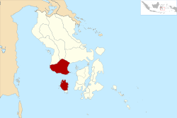 Location within Southeast Sulawesi | |
| Coordinates: 4°48′17″S 121°48′32″E | |
| Country | Indonesia |
| Province | Southeast Sulawesi |
| Capital | Rumbia |
| Government | |
| • Regent | Tafdil |
| • Vice Regent | Masyhura |
| Area | |
| • Total | 3,000.75 km2 (1,158.60 sq mi) |
| Population (2010) | |
| • Total | 139,235 |
| • Density | 46/km2 (120/sq mi) |
| Time zone | UTC+8 (ICST) |
| Area code | (+62) 405 |
| Website | bombanakab |

Administration
The regency is divided into 22 districts (kecamatan), tabulated below with their areas and their 2010 Census populations.[1]
| Name | English name | Area in km2 | Population Census 2010 |
|---|---|---|---|
| Kabaena Utara | North Kabaena | 127.78 | 3,671 |
| Kabaena Barat | West Kabaena | 46.77 | 7,492 |
| Kabaena | Kabaena | 103.49 | 2,849 |
| Kabaena Selatan | South Kabaena | 130.10 | 2,606 |
| Kabaena Tengah | Central Kabaena | 276.00 | 3,254 |
| Kabaena Timur | East Kabaena | 122.89 | 6,663 |
| (Most of Kabaena Island) | 807.03 | 26,535 | |
| Mata Oleo | 108.61 | 6,092 | |
| Poleang Tenggara | Southeast Poleang | 132.98 | 3,754 |
| Poleang Timur | East Poleang | 101.41 | 9,109 |
| Poleang Selatan | South Poleang | 89.51 | 6,602 |
| Poleang Utara | North Poleang | 236.77 | 10,454 |
| Tontonunu | 141.38 | 5,251 | |
| Poleang Tengah | Central Poleang | 30.53 | 3,480 |
| Poleang | 115.42 | 14,277 | |
| Poleang Barat | West Poleang | 329.12 | 11,269 |
| Mata Usu | 438.43 | 1,264 | |
| Lantari Jaya | 371.17 | 7,520 | |
| Rarowatu Utara | North Rarowatu | 187.44 | 7,359 |
| Rarowatu | 166.13 | 6,225 | |
| Rumbia | 58.75 | 10,710 | |
| Rumbia Tengah | Central Rumbia | 21.19 | 6,356 |
| Kepulauan Masaloka Raya | Masaloka Raya Islands | 2.78 | 2,978 |
References
- Biro Pusat Statistik, Jakarta, 2011.
Regencies and cities of Southeast Sulawesi | ||
|---|---|---|
Capital: Kendari | ||
| Regencies | ||
| Cities | ||
This article is issued from Wikipedia. The text is licensed under Creative Commons - Attribution - Sharealike. Additional terms may apply for the media files.