Blairsville, Pennsylvania
Blairsville is a borough in Indiana County, Pennsylvania, 42 miles (68 km) east of Pittsburgh, and on the Conemaugh River. As of the 2010 census it had a population of 3,412.[3]
Blairsville, Pennsylvania | |
|---|---|
Borough | |
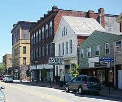 Market Street | |
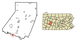 Location of Blairsville in Indiana County, Pennsylvania | |
 Blairsville Location of Blairsville in Indiana County, Pennsylvania  Blairsville Blairsville (the United States) | |
| Coordinates: 40°25′56″N 79°15′47″W | |
| Country | United States |
| State | Pennsylvania |
| County | Indiana |
| Settled | 1818 |
| Incorporated | 1825 |
| Government | |
| • Type | Borough Council |
| Area | |
| • Total | 1.41 sq mi (3.66 km2) |
| • Land | 1.41 sq mi (3.66 km2) |
| • Water | 0.00 sq mi (0.00 km2) |
| Elevation | 1,010 ft (310 m) |
| Population (2010) | |
| • Total | 3,412 |
| • Estimate (2018)[2] | 3,243 |
| • Density | 2,310.47/sq mi (891.80/km2) |
| Time zone | UTC-5 (Eastern (EST)) |
| • Summer (DST) | UTC-4 (EDT) |
| ZIP code | 15717 |
| Area code(s) | 724 - Exchange: 459 |
| FIPS code | 42-06904 |
| Website | blairsvilleboropa |
History
Blairsville was settled in 1818 and incorporated in 1825. In the past, railway shops, foundries, machine shops, enameling plants, and manufactories of plate glass and lumber employed the residents. It was the seat of Blairsville College, a Presbyterian institution opened in 1851. Just outside of the city limits in Burrell Township, the former auto repair trade school Wyotech, operated until 2018.
The Blairsville Armory and St. Peter's Episcopal Church and Rectory are listed on the National Register of Historic Places.[4]
In 1902, the countryside around Blairsville became one of the first in Pennsylvania to have a woman, Anna J. Devers, appointed as a Rural Free Delivery carrier, delivering mail from the Blairsville Post Office.[5]
M. C. Eignus (1844–1941), Illinois state representative, was born in Blairsville.[6]
Geography
Blairsville is located in the southern portion of Indiana County, bordered by the Conemaugh River, Westmoreland County, Pennsylvania to the south and west and Burrell Township to the north and east.
According to the United States Census Bureau, the borough has a total area of 1.41 square miles (3.66 km2), all of it land.[3]
Demographics
| Historical population | |||
|---|---|---|---|
| Census | Pop. | %± | |
| 1830 | 957 | — | |
| 1840 | 990 | 3.4% | |
| 1850 | 1,135 | 14.6% | |
| 1860 | 1,009 | −11.1% | |
| 1870 | 1,054 | 4.5% | |
| 1880 | 1,162 | 10.2% | |
| 1890 | 3,126 | 169.0% | |
| 1900 | 3,386 | 8.3% | |
| 1910 | 3,572 | 5.5% | |
| 1920 | 4,391 | 22.9% | |
| 1930 | 5,296 | 20.6% | |
| 1940 | 5,002 | −5.6% | |
| 1950 | 5,000 | 0.0% | |
| 1960 | 4,930 | −1.4% | |
| 1970 | 4,411 | −10.5% | |
| 1980 | 4,166 | −5.6% | |
| 1990 | 3,595 | −13.7% | |
| 2000 | 3,607 | 0.3% | |
| 2010 | 3,412 | −5.4% | |
| Est. 2018 | 3,243 | [2] | −5.0% |
| Sources:[7][8][9] | |||
At the 2000 census there were 3,607 people, 1,631 households, and 983 families residing in the borough. The population density was 2,591.3 people per square mile (1,001.9/km²). There were 1,830 housing units at an average density of 1,314.7 per square mile (508.3/km²). The racial makeup of the borough was 95.68% White, 2.99% African American, 0.11% Native American, 0.58% Asian, 0.06% from other races, and 0.58% from two or more races. Hispanic or Latino of any race were 0.06%.[8]
There were 1,631 households, 25.4% had children under the age of 18 living with them, 46.8% were married couples living together, 10.1% had a female householder with no husband present, and 39.7% were non-families. 36.3% of households were made up of individuals, and 19.1% were one person aged 65 or older. The average household size was 2.21 and the average family size was 2.90.
In the borough the population was spread out, with 22.4% under the age of 18, 6.5% from 18 to 24, 27.3% from 25 to 44, 22.7% from 45 to 64, and 21.2% 65 or older. The median age was 41 years. For every 100 females there were 88.8 males. For every 100 females age 18 and over, there were 85.2 males.
The median household income was $30,625 and the median family income was $38,585. Males had a median income of $32,563 versus $22,049 for females. The per capita income for the borough was $16,771. About 6.8% of families and 11.2% of the population were below the poverty line, including 15.7% of those under age 18 and 9.9% of those age 65 or over.
Education
Blairsville is served by the Blairsville-Saltsburg School District. The Blairsville high school and elementary schools are located at the intersection of Routes 22 and 119 in nearby Burrell Township.
References
- "2017 U.S. Gazetteer Files". United States Census Bureau. Retrieved Mar 24, 2019.
- "Population and Housing Unit Estimates". Retrieved November 16, 2019.
- "Geographic Identifiers: 2010 Census Summary File 1 (G001): Blairsville borough, Pennsylvania". American Factfinder. U.S. Census Bureau. Archived from the original on February 13, 2020. Retrieved April 10, 2018.
- "National Register Information System". National Register of Historic Places. National Park Service. July 9, 2010.
- http://www.newspapers.com/image/19988616/
- 'Official Directory of the Forty-Second General Assembly of Illinois-1901,' Talbott & Hamann Press, Springfield, Illinois: 1901, Biographical Sketch of M.C. Eignus, pg. 65
- "Census of Population and Housing". U.S. Census Bureau. Retrieved 11 December 2013.
- "U.S. Census website". United States Census Bureau. Retrieved 2008-01-31.
- "Incorporated Places and Minor Civil Divisions Datasets: Subcounty Resident Population Estimates: April 1, 2010 to July 1, 2012". Population Estimates. U.S. Census Bureau. Archived from the original on 11 June 2013. Retrieved 11 December 2013.
External links
- Borough of Blairsville official website
- Blairsville Municipal Authority, water and sewer service
- Blairsville Historical Society
- The Blairsville Dispatch
Municipalities and communities of Indiana County, Pennsylvania, United States | ||
|---|---|---|
| Boroughs |  | |
| Townships | ||
| CDPs | ||
| Unincorporated communities | ||
Pittsburgh metropolitan area | ||
|---|---|---|
| Counties |  Map of the Pittsburgh Tri-State with green counties in the metropolitan area and yellow counties in the combined area. | |
| Major cities | ||
| Cities and towns 15k–50k (in 2010) | ||
| Airports | ||
| Topics | ||
| ||
| Authority control |
|
|---|