Bishopston, Swansea
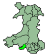
Bishopston (Welsh: Llandeilo Ferwallt, historically also Llanmerwallt and Llancyngur Trosgardi)[2] is a large village and community situated on the Gower Peninsula, some 6 miles (9.7 km) west south west of the centre of Swansea in South Wales.
Bishopston
| |
|---|---|
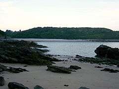 Pwll-Du Bay | |
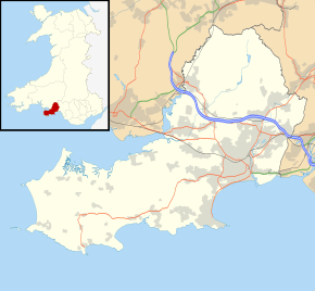 Bishopston Location within Swansea | |
| Population | 3,251 (ward 2011)[1] |
| OS grid reference | SS5888 |
| Community |
|
| Principal area | |
| Ceremonial county | |
| Country | Wales |
| Sovereign state | United Kingdom |
| Post town | SWANSEA |
| Postcode district | SA3 |
| Dialling code | 01792 |
| Police | South Wales |
| Fire | Mid and West Wales |
| Ambulance | Welsh |
| UK Parliament | |
| Senedd Cymru – Welsh Parliament |
|
It is partly within the Gower Peninsula Area of Outstanding Natural Beauty (AONB).
The church, located at the head of Bishopston Valley, is dedicated to St Teilo who gives the village its Welsh name. Bishopston gives its name to the Bishopston Mudstone, a name used by geologists to refer to a rock formation with a widespread occurrence in south Wales.
Etymology
The name Bishopston originates from the Norman conquest, however pre-Norman names for the town vary. One name was Llanmerwall (or Llanmerwallt), and is similar to the modern Welsh name. Two further names are recorded however, firstly Porthdulon (or Porthtulon) possibly referring to the area of Caswell, and the name Llancyngur Trosgardi.[2]
Shops and services
Bishopston has several shops including a Co-Op and Post Office. Other local services include a hotel and cafe, three public houses, a petrol station, retirement homes, post office, church halls, sports hall, medical centre and children's play area.
Education
The town has its own schools, Bishopston Primary School and Bishopston Comprehensive School. Bishopston Comprehensive School is expected to soon undergo a series of refurbishments, including the construction of a new block.
Tourist attractions
Many people visiting Bishopston are attracted to its coastline, mainly Caswell Bay because of its easy accessibility, car parking, seasonal bus service, shops and cafes, public toilets, open-air showers, and seasonal lifeguarding. Other Bishopston beaches, such as Pwll Du and Brandy Cove, which can only be visited on foot, remain untouched by the majority of visitors.
Beaches
Local beaches include Brandy Cove, Caswell Bay and Pwll Du. The electoral ward consists of part or all of the following areas: Barland Common, Caswell, Clyne Common (Welsh: Rhos-Glyn), Bishopston (Welsh: Llandeilo-ferwallt), Manselfield (Welsh: Maesyfaen), Murton (Welsh: Morthw), and Oldway (Welsh: Henlôn) in the parliamentary constituency of Gower.
It is bounded by the Bristol Channel to the south; and the wards of: Pennard (Welsh: Llanarthbodu) to the west; Fairwood (Welsh: Llwynffair) to the north; and Mayals, West Cross (Welsh: Crwys Fawr) and Newton (Welsh: Trenewydd) to the east.
Population and housing
Forming part of the Bishopston ward of the City and County of Swansea, it is one of the largest villages on Gower. The population of Bishopston has increased steadily from the beginning of the 19th century. In 1801, the first census of England and Wales reported that 303 people were living in 73 houses in the parish of Bishopston. By 1931 the population had increased to around 1,500 people living in 369 houses.[3] In 2001 the population of the village was 3,341.[4] The village experienced significant growth between the First and Second World Wars and in the 1960s.
Bishopston's rural location has influenced the pattern of its development. Most dwellings are detached or semi-detached and benefit from generous gardens. As a result, property in Bishopston is expensive by the standards of most of South Wales and is beyond the reach of many first time buyers. Nearly all of the property in Bishopston is privately owned, with only 1% of homes rented from the local authority.[4]
Bishopston and the Gower was named one of the best places to live in Wales in 2017.[5]
Sport
Bishopston has its own rugby club, South Gower RFC, and a football side named South Gower AFC.
References
- "Ward population 2011". Retrieved 13 April 2015.
- Williams, Nino (11 January 2020). "The lost Welsh place names of Gower". walesonline. Retrieved 12 January 2020.
- Orrin, G. R (1982) A History of Bishopston, Gomer Press. ISBN 0-85088-507-8
- Electoral Division Profile, Swansea .gov.uk
- "These towns have been named as the best places to live in Wales". Wales Online.
External links
- Bishopston Comprehensive School
- Bishopston Church
- Holiday and background information on the village of Bishopston
- Parish church of St Teilo
- South Gower Rugby Club
- Gower Peninsula AONB
City and County of Swansea | |||||||||||||||||||||
|---|---|---|---|---|---|---|---|---|---|---|---|---|---|---|---|---|---|---|---|---|---|
| |||||||||||||||||||||
| Authority control |
|
|---|