Denbighshire
Denbighshire (Welsh: Sir Ddinbych; [ˌsiːr ˈðɪnbɨ̞χ]) is a county in north-east Wales (but with borders differing from the eponymous historic county). This part of Wales is known to have been inhabited longest – Pontnewydd (Bontnewydd-Llanelwy) Palaeolithic site has Neanderthal remains from 225,000 years ago. Castles include Denbigh, Rhuddlan, Ruthin, Castell Dinas Bran and Bodelwyddan. St Asaph, one of Britain's smallest cities, has one of its smallest Anglican cathedrals. Denbighshire is bounded by coastline to the north and hills to the east, south and west. The River Clwyd creates a broad fertile valley with little industry. Crops appear in the Vale of Clwyd and cattle and sheep in the uplands. The coast attracts tourists; hikers frequent the Clwydian Range, forming an Area of Outstanding Natural Beauty with the upper Dee Valley. Llangollen hosts the Llangollen International Musical Eisteddfod each July.[1]
Denbighshire Sir Ddinbych | |
|---|---|
County and Principal area | |
 Coat of arms | |
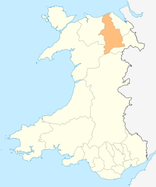
 Denbighshire shown within Wales | |
| Sovereign state | |
| Constituent country | |
| Preserved county | Clwyd |
| Established | 1 April 1996 |
| Administrative HQ | Ruthin |
| Largest town | Rhyl |
| Government | |
| • Type | Principal council |
| • Body | Denbighshire County Council |
| • Executive | TBA (council NOC) |
| • Leader | Hugh Evans (Independent) |
| • Chairman | Pete Prendergast |
| • Chief Executive | Judith Greenhalgh |
| • MPs | James Davies (C) David Jones (C) Simon Baynes (C) |
| Area | |
| • Total | 326 sq mi (844 km2) |
| Area rank | 8th |
| Population (2017) | |
| • Total | 95,330 |
| • Rank | 16th |
| • Density | 300/sq mi (114/km2) |
| • Ethnicity | 99.3% white |
| Time zone | UTC+0 (Greenwich Mean Time) |
| • Summer (DST) | UTC+1 (British Summer Time) |
| GSS code | W06000004 |
| ISO 3166-2 | GB-DEN |
| NUTS 3 code | UKL13 |
| ONS code | 00NG |
| Website | www.denbighshire.gov.uk |
Formation
The present main area was formed on 1 April 1996 under the Local Government (Wales) Act 1994, from various parts of the county of Clwyd. It includes the district of Rhuddlan (which was formed in 1974 entirely from Flintshire), the communities of Trefnant and Cefn Meiriadog from the district of Colwyn (which was entirely Denbighshire) and most of the Glyndŵr district. The part of the Glyndŵr district includes the entirety of the former Edeyrnion Rural District, which was part of the administrative county of Merionethshire before 1974, which covered the parishes of Betws Gwerfil Goch, Corwen, Gwyddelwern, Llangar, Llandrillo yn Edeirnion and Llansanffraid.[2]
Other principal areas including part of historic Denbighshire are Conwy, which picked up the remainder of 1974–1996 Colwyn, and the Denbighshire parts of 1974–1996 Aberconwy, and Wrexham, which corresponds to the pre-1974 borough of Wrexham along with most of the Wrexham Rural District and several parishes from Glyndŵr. Post-1996 Powys includes the historic Denbighshire parishes of Llanrhaeadr-ym-Mochnant, Llansilin and Llangedwyn, which formed part of Glyndŵr district.[2]
Early history
Researchers have found evidence that Denbighshire was inhabited at least 225,000 years ago. Bontnewydd Palaeolithic site is one of the most significant in Great Britain. Hominid remains of probable Neanderthals have been found, along with stone tools from the later Middle Pleistocene.[3]
Geography
- See also List of places in Denbighshire.
The eastern border of Denbighshire follows the ridge of the Clwydian Range, with a steep escarpment to the west, and a high point at Moel Famau (1,820 ft (555 m)).[4] The Clwydian Range is, with the upper Dee Valley, an Area of Outstanding Natural Beauty – one of just five in the whole of Wales.[5] The Denbigh Moors (Mynydd Hiraethog) are in the west of the county and the Berwyn Range adjacent to the southern boundary. The River Clwyd in its broad, fertile Vale runs from south to north in the centre of the county. There is a narrow coastal plain in the north where there is much residential and tourist development.[4] The highest point in the historic county is Cadair Berwyn (height 832 m or 2,730 ft), though border changes since 1974 make Cadair Berwyn North Top(height 827 m or 2,713 ft) the high point of the current council area. Denbighshire borders the counties of Conwy, Flintshire, Wrexham, and Powys (Montgomeryshire).
Population
Denbighshire's total population at the United Kingdom Census 2001 was 93,065, which increased to 93,734 at the 2011 census.[6] The largest towns on the coast are Rhyl (2001 population c. 25,000) and Prestatyn (2001 population c. 18,000). According to the 2011 Census returns, 24.6 per cent of the population stated they are able to speak Welsh.[7]
In 2019, research carried out by UnHerd in association with pollster FocalData showed that most people across the county support the British monarchy.[8]
Economy
Since the 20th-century demise of the coal and steel industries in the Wrexham area, there are no heavy industrial sites in the county. Although most towns have small industrial parks or estates for light industry, the economy is based on agriculture and tourism. A high proportion of the working population is employed in the service sector. The uplands support sheep and beef cattle rearing, while in the Vale of Clwyd dairy farming and wheat and barley crops predominate.[9] Many towns have livestock markets and the farming supports farm machinery merchants, vets, feed merchants, contractors and other ancillary trades.[10] With their incomes on the decline, farmers have found opportunities in tourism, rural crafts, specialist food shops, farmers' markets and value-added food products.[11]
Tourism is nowadays the main source of income. The upland areas with their sheep farms and small, stone-walled fields are attractive to visitors. Redundant farm buildings are often converted into self-catering accommodation, while many farmhouses supply bed and breakfast. The travel trade began with the arrival of the railway on the coast in the mid-19th century, opening up the area from Merseyside. This led to a boom in seaside guest houses. More recently, caravan sites and holiday villages have thrived and there has been an increase in ownership of holiday homes.[12] Various initiatives to boost the economy of North Wales are in progress in 2016, including a redevelopment project for the former Rhyl seafront and funfair.[13]
Transport
The North Wales Coast Line running from Crewe to Holyhead is served by Transport for Wales and Avanti West Coast services. Trains leaving Crewe pass through Chester, cross the River Dee into Wales, and continue through Flint, Shotton, Holywell junction, Prestatyn, Rhyl, and stations to Bangor and Holyhead, from where there is a ferry service to Ireland.[14]
There are no motorways in Denbighshire. The A55 dual carriageway passes from Chester through St Asaph to the North Wales coast at Abergele, after which it runs parallel to the railway through Conwy and Bangor to Holyhead. The A548 passes from Chester to Abergele through Deeside and along the coast, before leaving the coast and terminating at Llanrwst. The main road from London is the A5 which passes north-westwards through Llangollen, Corwen and Betws-y-Coed to join the A55 and terminate at Bangor. The A543 crosses the Denbigh Moors from south-east to north-west, and the A525 links Ruthin with St Asaph.[15] There are local bus services between the main towns. Several services by Arriva Buses Wales run along the main coast road between Chester and Holyhead, linking the coastal resorts. Another route links Rhyl to Denbigh.[16]
Politics
Denbighshire is represented in the House of Commons by three MPs. The Welsh Labour Party was wiped out of Denbighshire by the Welsh Conservatives in the 2019 general election for the first time ever[17]
The following MPs were elected from Denbighshire in 2019:
- Simon Baynes (C) in Clwyd South, first elected in 2019.[18]
- David Jones (C) in Clwyd West, first elected in 2005.[19]
- James Davies (C) in Vale of Clwyd, first elected in 2019.[20]
Denbighshire is also represented in the Senedd by three Members of the Senedd (MSs).
The following MSs were elected from Denbighshire in 2016:
See also
References
- "Attractions in Clwyd". Britain Express. Retrieved 21 April 2016.
- "Local Government (Wales) Act 1994". The National Archives. legislation,gov.uk. Retrieved 1 May 2016.
- "Pontnewydd Cave". University of Central Lancashire. Retrieved 1 May 2016.
- Philip's (1994). Modern School Atlas. George Philip & Son. p. 26. ISBN 0-540-05278-7.
- "Clwydian Range". North East Wales. Archived from the original on 19 April 2014. Retrieved 30 April 2016.
- "Local Authority population 2011". Retrieved 22 May 2015.
- Stat Wales Retrieved 1 May 2016.
- "People in Denbighshire still back the monarchy". Denbighshire Free Press. Retrieved 14 December 2019.
- "Clwyd". NFU Cymru. 5 December 2014. Retrieved 1 May 2016.
- Morris, Jan (2014). Wales: Epic Views of a Small Country. Penguin Books Limited. p. 234. ISBN 978-0-241-97024-9.
- Nienaber, Birte (2016). Globalization and Europe's Rural Regions. Routledge. pp. 76–83. ISBN 978-1-317-12709-3.
- Boniface, Brian G.; Cooper, Chris; Cooper, Robyn (2012). Worldwide Destinations: The Geography of Travel and Tourism. Routledge. pp. 129, 152–153. ISBN 978-0-08-097040-0.
- "Six projects to kick-start the North Wales economy in 2016". Daily Post. 1 January 2016. Retrieved 1 May 2016.
- "Crewe to Holyhead". North Wales Coast Railway. 2012. Retrieved 30 April 2016.
- Concise Road Atlas: Britain. AA Publishing. 2015. pp. 47–55. ISBN 978-0-7495-7743-8.
- "Discover the towns of Wales". Arriva Wales. Arriva Buses Wales. Retrieved 30 April 2016.
- "General Election 2019: Tories win overall majority as Labour suffer in North Wales". Denbighshire Free Press. Retrieved 14 December 2019.
- "Clwyd South parliamentary constituency – Election 2019". Retrieved 14 December 2019.
- "Clwyd West parliamentary constituency – Election 2019". Retrieved 14 December 2019.
- "Vale of Clwyd parliamentary constituency – Election 2019". Retrieved 14 December 2019.
- "Clwyd South – Welsh Assembly constituency – Election 2016". Retrieved 14 December 2019.
- "Clwyd West – Welsh Assembly constituency – Election 2016". Retrieved 14 December 2019.
- "Vale of Clwyd – Welsh Assembly constituency – Election 2016". Retrieved 14 December 2019.
External links
| Wikimedia Commons has media related to Denbighshire. |
| Wikivoyage has a travel guide for Denbighshire. |
- Denbighshire at Curlie
- Denbighshire landscape