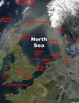
Southern Bight
Southern Bight is the southern bight of the North Sea bounded by the coasts of the Netherlands, Belgium, France and Great Britain. The Southern Bight is south west of the German Bight and the Wadden Sea. The Southern Bight is roughly delimited in the north by the line The Wash-West Frisian Islands, south of the Dogger Bank, a large shallow part in the North Sea, and the Outer Silver Pit, a deep water channel south of the Dogger Bank.
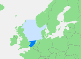
There are many sand banks in the Southern Bight. From the Strait of Dover to the Norfolk Banks, there is a deep water channel, which enters into wherein the water is about 30 metres deep or deeper. At the end of the English Channel, this depth increases to about 100 metres.[1]
The North Sea as a whole has characteristics which are similar to those of the Atlantic Ocean, whereas the Southern Bight has hydrography characteristics which most resemble those of the English Channel, and the inputs from various European rivers. The bight's four main river sources are the Rhine, Meuse, Scheldt and the Thames, but it is also impacted by the Ems, Elbe, and Humber.[2]
See also
References
- Dirk J.Beets, Adam J.F.van der Spek (18 August 1999), The Holocene evolution of the barrier and the back-barrier basins of Belgium and the `Netherlands as a function of late Weichselian morphology,relative sea-level rise and sediment supply (PDF), archived from the original (PDF) on 27 September 2007, retrieved 2007-07-25
- OSTC Federal Office for Scientific, Technical and Cultural Affairs, CArbon, NitrOgen and Phosphorus cYcling in the North Sea (CANOPY)e sea-level rise and sediment supply, retrieved 2007-07-25