Baranavichy
Baranavichy (/bəˈrɑːnəvɪtʃiː/ (![]()
Baranavichy Баранавічы | |
|---|---|
.jpg) | |
 Flag  Coat of arms | |
 Baranavichy Location in Belarus | |
| Coordinates: 53°08′N 26°01′E | |
| Country | |
| Voblast | Brest Region |
| Raion | Baranavichy District |
| Mentioned | 1706 |
| Founded | 1871 |
| City Status | 1919 |
| Area | |
| • Total | 53.64 km2 (20.71 sq mi) |
| Elevation | 193 m (633 ft) |
| Population (2019) | |
| • Total | 179,000 |
| • Density | 3,300/km2 (8,600/sq mi) |
| Time zone | UTC+2 (EET) |
| • Summer (DST) | UTC+3 (EEST) |
| Postal code | 225320 |
| Area code(s) | +375 (0)163 |
| Vehicle registration | 1 |
| Website | www |
History
Early history
In the second half of the 17th century, Baranavichy housed the Jesuit mission. In the second half of the 18th century, Baranavichy was the property of Massalski and Niesiołowski families. The village was administratively part of the Nowogródek Voivodeship until the Third Partition of Poland (1795), when it was annexed by Imperial Russia. In the 19th century, it belonged to the Countess E.A. Rozwadowski. It was part of the Novogrodek (now Navahrudak) okrug, which was part of Slonim Governorate, the Lithuania Governorate, the Grodno Governorate and then the Minsk Governorate.
Growth
.jpg)
The town's history began on 17 (29) November 1871, the beginning of construction of a movement to the new section of the Smolensk-Brest. The name of the station arose during construction was that the nearby village, Baranavichy, whose first mention in the testament of A.E Sinyavskaya in 1627. Then, in 1871, not far from the station, the locomotive depot was built.
In 1874 was the appearance of the railway junction. In the wooden station buildings lived the railway workers of Baranavichy. The new railway linked Moscow with the western outskirts of Imperial Russia.
The impetus for more intensive settlement of the areas adjacent to the station from the south was the May 27, 1884 decision by the governor of Minsk to build a town, Rozvadovo, on the lands of the landlord, Rozwadowski. The town was built according to the governor's plan approved. In the village were 120 houses and 500 people.
The plans approved by Emperor Alexander III assumed that there would be also one railway linking Vilnius, Luninets, Pinsk and Rovno. Therefore, 2.5 km from the station, the Moscow-Brest railway crossed the track Vilnius-Rovno from Polesie railways. At the junction was another station, Baranavichy (according to Polesie Railways), which became the second centre of the city.
As before, workers and traders settled near the station. The new settlement was called New Baranavichy, unlike Rozvadovo, which became informally called Old Baranavichy. It was developed on the land owned by peasants of the villages near the new station (Svetilovichi, Gierow and Uznogi). More convenient than the landlords' land, its lease terms and proximity to administrative agencies contributed to the rapid growth of this settlement.
20th century
At the beginning of World War I, Baranavichy was the location for the Stavka, the headquarters of the Russian General Staff, but after the Great Retreat of Russians from Congress Poland, it became a frontline city. It was taken by the German Empire during the Baranovichi Offensive of 25 July 1916 and was under German occupation for two years. Finally, the Germans surrendered the town to Belarusian People's Republic.
_(2).jpg)
After the settlement was left by the Germans in January 1919, it was captured by the Soviets. In the early stages of the Polish–Soviet War, it was briefly captured by the Poles on 18 March 1919[1] and again captured, for longer, in April 1919,[2] five months after Poland regained independence. The Russians retook it on 17 July 1920, but the Poles took it again on 30 September 1920.
.JPG)
On 1 August 1919, it received city rights and became a powiat centre in the Polish Nowogródek Voivodeship. In 1921, Baranowicze had over 11,000 inhabitants (67% Jews, the rest being mostly Belarusians, Poles and Russians). Soon, the city started to grow and became an important centre of trade and commerce for the area. The city's Orthodox cathedral was built in the Neoclassical style in 1924 to 1931 and was decorated with mosaics that had survived the demolition of the Alexander Nevsky Cathedral, Warsaw. In 1930, a monument to Hungarian Lieutenant colonel Artur Buol, a hero of Polish fights in the Polish–Soviet War, was unveiled in Baranowicze.[3] In the interbellum, grandparents and father of Polish politicians Lech Kaczyński and Jarosław Kaczyński lived in Baranowicze.[4]
The city was also an important military garrison, with a KOP Cavalry Brigade, the 20th Infantry Division and the Nowogródzka Cavalry Brigade stationed there. Because of the fast growth of local industry, a local branch of the Polish Radio was opened in 1938. In 1939 Baranavichy had almost 30,000 inhabitants and was the biggest and the most important city in the Nowogródek Voivodeship.
After the invasion of Poland, the Soviet Union took the city on 17 September 1939, and annexed it to the Byelorussian Soviet Socialist Republic. The local Jewish population of 9,000 was joined by approximately 3,000 Jewish refugees from the Polish areas occupied by Germany. After the start of Operation Barbarossa, the city was seized by the Wehrmacht on June 25, 1941. It was part of Generalbezirk Weißruthenien in Reichskommissariat Ostland during the German occupation. In August 1941, a ghetto was created in the city, with more than 12,000 Jews kept in terrible conditions in six buildings at the outskirts. From March 4 to December 14, 1942, the entire Jewish population of the ghetto was sent to various German concentration camps and killed in gas chambers. Only about 250 survived the war.[5]
The city was liberated by the Red Army on 8 July 1944.[6] It was also the seat of the Baranavichy Voblast from 1939 to 1941 and again from 1944 to 1954. Meanwhile, intensive industrialization took place. In 1991, the city became part of independent Belarus.
Climate
| Climate data for Baranavichy | |||||||||||||
|---|---|---|---|---|---|---|---|---|---|---|---|---|---|
| Month | Jan | Feb | Mar | Apr | May | Jun | Jul | Aug | Sep | Oct | Nov | Dec | Year |
| Record high °C (°F) | 11.0 (51.8) |
15.1 (59.2) |
20.1 (68.2) |
29.0 (84.2) |
31.5 (88.7) |
32.9 (91.2) |
34.7 (94.5) |
35.7 (96.3) |
31.5 (88.7) |
26.1 (79.0) |
17.8 (64.0) |
11.1 (52.0) |
35.7 (96.3) |
| Average high °C (°F) | −1.7 (28.9) |
−0.8 (30.6) |
4.5 (40.1) |
12.8 (55.0) |
19.1 (66.4) |
21.6 (70.9) |
23.9 (75.0) |
23.3 (73.9) |
17.4 (63.3) |
11.0 (51.8) |
3.7 (38.7) |
−0.7 (30.7) |
11.2 (52.2) |
| Daily mean °C (°F) | −4.1 (24.6) |
−3.8 (25.2) |
0.6 (33.1) |
7.6 (45.7) |
13.5 (56.3) |
16.2 (61.2) |
18.3 (64.9) |
17.5 (63.5) |
12.3 (54.1) |
7.1 (44.8) |
1.3 (34.3) |
−2.9 (26.8) |
7.0 (44.6) |
| Average low °C (°F) | −6.5 (20.3) |
−6.6 (20.1) |
−2.8 (27.0) |
2.9 (37.2) |
8.0 (46.4) |
11.1 (52.0) |
13.1 (55.6) |
12.3 (54.1) |
8.0 (46.4) |
3.8 (38.8) |
−0.8 (30.6) |
−5.1 (22.8) |
3.1 (37.6) |
| Record low °C (°F) | −34.5 (−30.1) |
−35.4 (−31.7) |
−28.8 (−19.8) |
−9.6 (14.7) |
−4.1 (24.6) |
0.9 (33.6) |
3.9 (39.0) |
−0.5 (31.1) |
−3.4 (25.9) |
−11.2 (11.8) |
−19.5 (−3.1) |
−29.9 (−21.8) |
−35.4 (−31.7) |
| Average precipitation mm (inches) | 39 (1.5) |
32 (1.3) |
40 (1.6) |
33 (1.3) |
59 (2.3) |
83 (3.3) |
94 (3.7) |
59 (2.3) |
57 (2.2) |
43 (1.7) |
42 (1.7) |
46 (1.8) |
627 (24.7) |
| Average rainy days | 9 | 7 | 8 | 11 | 15 | 15 | 15 | 12 | 13 | 14 | 13 | 10 | 142 |
| Average snowy days | 16 | 16 | 11 | 3 | 0.1 | 0 | 0 | 0 | 0 | 2 | 8 | 15 | 71 |
| Average relative humidity (%) | 87 | 84 | 79 | 69 | 68 | 73 | 74 | 73 | 79 | 83 | 88 | 89 | 79 |
| Source: Pogoda.ru.net[7] | |||||||||||||
Sights
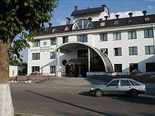
As a fairly young city, Baranavichy does not have many cultural heritage monuments. Most are buildings erected in the interwar period, including the Catholic Church of the Exaltation of the Holy Cross, the former Bank of Poland building, the building of the Polish Radio Baranowicze station, the fire station and the Orthodox Church of the Protection of the Holy Virgin. Few old houses from the early 20th century are preserved. There is a railway museum in the city.
.jpg) Church of the Exaltation of the Holy Cross
Church of the Exaltation of the Holy Cross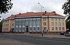 Former Bank of Poland building
 Polish Radio Baranowicze station
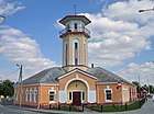 Pre-war fire station
 Church of the Protection of the Holy Virgin
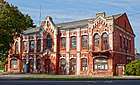 One of preserved old townhouses
Transport


The city is on the main east-west highway in Belarus, the M1, which forms a part of European route E30.
The first rail line through the city opened in around 1870. Additional railways built helped the city become an important rail junction.
The large airbase, north of the city, is used by the Belarusian Air Force.
People
- Mirosław Araszewski, Polish photographer and cinematographer
- Maja Berezowska, Polish painter
- Alina Kabata-Pendias (1929-2019), scientist
- Lidia Korsakówna, Polish theater and film actress
- Kazimierz Świątek, Roman Catholic Cardinal and archbishop
- Elchonon Wasserman, rabbi
- Rosh Yeshiva
- Valeriya Novodvorskaya, Soviet dissident, writer and liberal politician
- Valanсin Taŭlaj (be:Валянцін Таўлай), Belarusian Soviet poet
International relations
Twin towns — sister cities
Baranavichy is twinned with:[8]


Significant depictions in popular culture
- Baranavichy is one of the starting towns of Lithuania in the turn-based strategy game Medieval II: Total War: Kingdoms.[9]
See also
References
- Lech Wyszczelski, Wojna polsko-rosyjska 1919–1920, Bellona, Warsaw, 2010, p. 70 (in Polish)
- Paweł Wlezień. "Baranowicze – Nowogródek kwiecień 1919". Historia Wojskowa (in Polish). Retrieved 22 October 2019.
- Sławek Zagórski. "Artur Buol - węgierski bohater Wojska Polskiego". Menway w Interia.pl (in Polish). Retrieved 22 October 2019.
- "Kim był ojciec Jarosława i Lecha Kaczyńskich?". Fakt24.pl (in Polish). Retrieved 22 October 2019.
- Baranavichy. Holocaust
- Soviet General Staff, Operation Bagration, ed. & trans. R. W. Harrision, Helion & Co., Ltd., Solihull, UK, 2016, Kindle ed., vol. 2, ch. 10
- "Weather and Climate-The Climate of Baranavichy" (in Russian). Weather and Climate. Retrieved 14 May 2015.
- "Города-побратимы". baranovichy.by (in Russian). Baranovichy. Retrieved 2020-01-12.
- "Lithuania (M2TW-K-TC faction)". wiki.totalwar.com. Retrieved 27 November 2019.
External links
| Wikimedia Commons has media related to Baranavičy. |
- Baranavichy city portal
- Modern views of Baranavichy
- INTEX-PRESS online - latest news of Baranavichy region
- Public Transport in Baranavichy
- Baranavichy University Photos
Sports-related links:
History-related links:
- Photos on Radzima.org
- Baranowicze Radio Station
- Pre-war photos of Baranavichy
- Baranavichy in history
- Baranavichy. Synagogues
- British 1:25,000 map from 1943
| Districts (raiony) |  | |
|---|---|---|
| Cities | ||