Bamenda
Bamenda, also known as Abakwa and Mankon Town,[2] is a city in northwestern Cameroon and capital of the Northwest Region. The city has a population of about 2 million people and is located 366 kilometres (227 mi) north-west of the Cameroonian capital, Yaoundé. Bamenda is known for its cool climate and scenic hilly location.
Bamenda | |
|---|---|
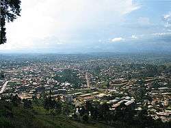 Bamenda from the mountain road into town | |
| Nicknames: Abakwa, which of date is made of three villages Mankon, Bamendankwe and Nkwen
Bamenda presently contains the highest number of English speaking Cameroonians | |
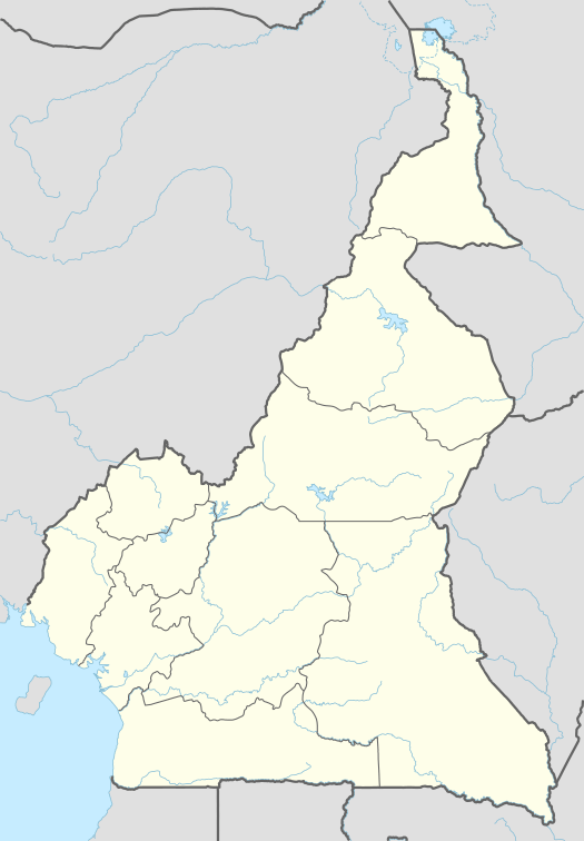 Bamenda Map of Cameroon showing the location of Bamenda | |
| Coordinates: 5°56′N 10°10′E | |
| Country | Cameroon |
| Region | Northwest |
| Department | Mezam |
| Government | |
| • Delegate | Vincent Ndumu |
| Elevation | 1,614 m (5,295 ft) |
| Population (2012)[1] | |
| • City | 348,766 |
| • Urban | 2,000,000 |
| (Census) | |
| Time zone | UTC+1 (WAT) |
| Website | Official website |
History
Colonial era
The origins of the city are related to the settlement of the Tikar people who culturally forged and maintained relations with the Kingdom of Bamum in the 1700s.[3] In 1884, the city was colonized by Germany until 1916 when it became a colony administered by Great Britain and France.[4] In 1919, the administration of Northwest Region and thus the city of Bamenda became only British. In 1961, the region joined the Cameroon.[5]
Ambazonian aspirations
Many of the city's inhabitants are English-speaking, and Cameroonian Pidgin English is the main language spoken in the shops and on the streets of Bamenda. On 31 March 2019, the SCNC and several Ambazonian movements agreed to create the Southern Cameroons Liberation Council, a united front consisting of both separatists and federalists aiming for an independent Ambazonian state.[6]
Cosmopolitan area
The city is made up of 3 villages; Mankon,Nkwen, Bamendakwe. However,it is surrounded by other suburban areas and villages like Bambui,Akum,Bafut,Bali, Chombah and Mbatu.This sub urban areas and villages are fast growing and sometimes considered as part of Bamenda.
Economy
The main industries are the processing of agricultural produce such as coffee, elementary food processing, handicraft, cottage industry, education (schools), tourism/hospitality, construction works and transport.[7] The local museum and shops display a wide variety of local baskets, beads, woodcarvings and bronze statues.
In Bamenda, there are cultural sites such; as the Mankon Fon's Palace with its newly constructed museum,[8] and the Bali Fon's palace with its ancient architectural structures. The mountainous terrain around the city affords scenic views such as that from the mountain Sabga over the Ndop plain.
Transports
The city of Bamenda has road links to Yaoundé and Douala, as well as an airport, Bamenda Airport, located in Bafut subdivision.
Geography
North of the city is the Bamenda Ring Road, a 367 kilometres (228 mi) circular route through Cameroon Highlands.[9] Along this road is Mount Oku 3,000 metres (9,800 ft), the Kimbi River Game Reserve, the Menchum River waterfalls, a huge Fon's palace at Bafut, and a pyramidal thatched shrine at Akum (also known as Bagangu).
Climate
Bamenda has a tropical savanna climate (Köppen: Aw), bordering on a tropical monsoon climate (Köppen: Am), with a long summer wet season and considerably less rainfall in the winter.[10]
| Climate data for Bamenda | |||||||||||||
|---|---|---|---|---|---|---|---|---|---|---|---|---|---|
| Month | Jan | Feb | Mar | Apr | May | Jun | Jul | Aug | Sep | Oct | Nov | Dec | Year |
| Average high °C (°F) | 25.9 (78.6) |
26.8 (80.2) |
26.3 (79.3) |
25.6 (78.1) |
24.8 (76.6) |
23.9 (75.0) |
22.1 (71.8) |
22.1 (71.8) |
23.9 (75.0) |
23.4 (74.1) |
24.2 (75.6) |
25.5 (77.9) |
24.5 (76.1) |
| Average low °C (°F) | 13.2 (55.8) |
14.5 (58.1) |
16.4 (61.5) |
16.7 (62.1) |
16.7 (62.1) |
16.0 (60.8) |
15.4 (59.7) |
15.5 (59.9) |
15.5 (59.9) |
15.8 (60.4) |
14.7 (58.5) |
13.1 (55.6) |
15.3 (59.5) |
| Average rainfall mm (inches) | 11.6 (0.46) |
29.4 (1.16) |
118.9 (4.68) |
178.1 (7.01) |
175.3 (6.90) |
266.7 (10.50) |
410.0 (16.14) |
411.9 (16.22) |
389.7 (15.34) |
227.8 (8.97) |
31.6 (1.24) |
9.1 (0.36) |
2,260.1 (88.98) |
| Average rainy days (≥ 0.1 mm) | 2 | 3 | 12 | 19 | 21 | 24 | 27 | 27 | 27 | 23 | 6 | 1 | 192 |
| Source: World Meteorological Organization[11] | |||||||||||||
According to the World Health Organization, Bamenda is the most polluted city in Africa in terms of PM2.5 particulate matter.[12]
Education
The Bamenda University of Science and Technology (BUST) is a brain child of The Industrial and Educational Development Company Ltd (INDECO). It was incorporated on 12 October 1995.
INDECO and the university (BUST) were founded by the Late Rt. Hon. Dr. John Ngu Foncha, with the encouragement of the Cameroon Government. The university went operational in January 1998. At the request of government, BUST participated and contributed extensively to the drafting of the Law on Private Higher Education in Cameroon.
BUST is a 4-year Arts, Science and Technology University. Degrees offered include B.A., BEd, BSc, HND.,SRN., AN., Lab. Tech., and Assist. Lab. Tech. Formalities for Post Graduate Studies have been put in place, to go operational by the academic year 2010/2011.
Its main national affiliate is the University of Buéa, though other partnership arrangements are under way with the University of Dschang. The Bamenda University of Science and Technology is affiliated to the University of Osnabrück (Germany) and the University of Wales at Bangor.[13]
There is also the University of Bamenda located in Bambili Town, founded in 2011.[14] It trains college teachers, medical doctors etc. and graduates in Accountancy, management, marketing, and a number of other fields of study.
Another institution of higher learning is National Polytechnic Bamenda, formerly National Polytechnic Bambui.
Places of worship
Among the places of worship, they are predominantly Christian churches and temples : Roman Catholic Archdiocese of Bamenda (Catholic Church), Evangelical Church of Cameroon (World Communion of Reformed Churches), Presbyterian Church in Cameroon (World Communion of Reformed Churches), Cameroon Baptist Convention (Baptist World Alliance), Full Gospel Mission Cameroon (Assemblies of God).[15] There are also Muslim mosques.
Sports
Over the years, Bamenda has had two football teams that played in the First Division Championship. In the 1970s, it was PWD Bamenda and later in the 1980s, it was Camark Bamenda. With the fall in the influence and budgeting of public works department and National Produce Marketing Board (NPMB), both teams fell from the limelight. Presently Camark Bamenda is out of existence, while PWD Bamenda is currently rising after a slump to the third tier for almost 20 years. Last season they were promoted to the first division following union Douala dropping points on the last day. The only club in the professional league at the moment is Yong Sports Academy. They are the current winners of the Cameroon cup (2013).
Politics
Bamenda is the founding place and seat of the largest opposition political party in Cameroon, the Social Democratic Front (SDF), and the home of its leader, John Fru Ndi. There is a large military presence throughout the city. On 26 May 1990, a group of Bamenda elites launched the party in Ntarikon Bamenda, despite a heavy police presence. However, the launching did not end without casualty. Six civilians were killed.
Bamenda is also the birthplace of The Southern Cameroons National Council (SCNC), a group that has been asking for the restoration of the former British Southern Cameroons, a territory that covers the English-speaking provinces of North West and South West. The SCNC was born in Bamenda in 1994, after the All Anglophone Conference (AAC2) issued the Bamenda Declaration in which it had asked the government of President Paul Biya to respond to all anglophone grievances stated in the Buea Declaration of 1993, or face the wrath of the people of the Southern Cameroons. The Cameroon government failed to respond to the Bamenda Declaration and since then, the SCNC has categorically maintained that it now considers the restoration of the independence of the Southern Cameroons to be final and irrevocable.[16]
References
- "World Gazetteer".
- F. E. Ngende (1966). Geography of West Cameroon. Basel Mission. p. 45.
- Toyin Falola, Daniel Jean-Jacques, Africa: An Encyclopedia of Culture and Society [3 volumes]: An Encyclopedia of Culture and Society, ABC-CLIO, USA, 2015, p. 142
- Emmanuel Mbah, Environment and Identity Politics in Colonial Africa: Fulani Migrations and Land Conflict, Taylor & Francis, UK, 2016, p. 20
- Emmanuel Mbah, Environment and Identity Politics in Colonial Africa: Fulani Migrations and Land Conflict, Taylor & Francis, UK, 2016, p. 21
- Anglophone Struggle Takes Another Kink, Separatists, Federalists Bury Hatchet, Create Southern Cameroons Liberation Council Archived 7 April 2019 at the Wayback Machine, The National Times, 1 Apr 2019. Accessed 1 Apr 2019.
- Britannica, Bamenda, britannica.com, USA, accessed on 7 July 2019
- "Mankon Museum". Centro Orientamento Educativo. Archived from the original on 26 September 2007. Retrieved 2 February 2011.
- Mark Dike DeLancey, Mark W. Delancey, Rebecca Neh Mbuh, Historical Dictionary of the Republic of Cameroon, Rowman & Littlefield, USA, 2019, p. 57
- Climate Bamenda, Climate-Data.org. Retrieved 25 February 2019.
- "World Weather Information Service — Bamenda". World Meteorological Organization. Retrieved 19 October 2015.
- Jayshree, Nandi (12 May 2016). "Delhi no more the most polluted city in the world, says WHO report". The Times of India. Retrieved 12 May 2016.
- "Homepage of Bameda University". Archived from the original on 14 July 2014. Retrieved 6 July 2014.
- "Education in Cameroon". CameroonWeb. Retrieved 11 September 2018.
Originally The University of Buea was the only Anglo-Saxon style university, but with the University of Bamenda opening its doors in 2011 Cameroon now has two English Universities.
- J. Gordon Melton, Martin Baumann, ‘'Religions of the World: A Comprehensive Encyclopedia of Beliefs and Practices'’, ABC-CLIO, USA, 2010, p. 484-486
- "BAMENDA: A FORGOTTEN CITY AND THE PEOPLE CRY FOR GOOD ROADS". www.bareta.news. Retrieved 29 November 2017.
External links
![]()