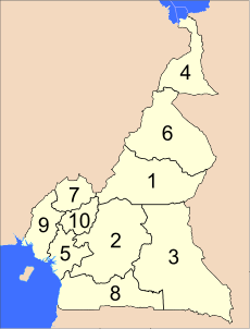
Regions of Cameroon
The Republic of Cameroon is divided into ten regions:
|
| Regions of Cameroon Régions du Cameroun (French) | |
|---|---|
 | |
| Category | Unitary State |
| Location | Republic of Cameroon |
| Number | 10 |
| Populations | 731,088 (South Region) – 3,919,828 (Centre Region) |
| Areas | 13,890 km2 (5,364 sq mi) (West Region) – 109,000 km2 (42,086 sq mi) (East Region) |
| Government | Semi-Autonomous Region government |
| Subdivisions | Department |
 |
|---|
| This article is part of a series on the politics and government of Cameroon |
|
Government |
|
|
Administrative divisions
|
|
|
|
|
In 2008, the President of the Republic of Cameroon, President Paul Biya signed decrees abolishing "provinces" and replacing them with "regions". Hence, all of the country's ten provinces are now known as regions.
Most of these provinces were designated in the 1960s alongside Centre-South Province (split into Centre and South in 1983). At the same time, Adamawa and Far North Provinces were split from North Province. See summary of administrative history in Zeitlyn 2018.[1]
References
- Zeitlyn, David (2018-08-03). "A summary of Cameroonian Administrative history". Vestiges: Traces of Record. 4 (1): 1–13.
- Law, Gwillim (2005): Provinces of Cameroon, statoids.com (accessed 3 June 2006).
This article is issued from Wikipedia. The text is licensed under Creative Commons - Attribution - Sharealike. Additional terms may apply for the media files.