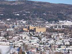
Baie-Saint-Paul
Baie-Saint-Paul (2011 Population 7,332; UA population 4,535) is a city in the Province of Quebec, Canada, on the northern shore of the Saint Lawrence River. Baie-Saint-Paul is the seat of Charlevoix Regional County Municipality. The city is situated at the mouth of the Gouffre River. It is known for its art galleries, shops and restaurants.
Baie-Saint-Paul | |
|---|---|
City | |
 | |
.svg.png) Coat of arms | |
 Location within Charlevoix RCM. | |
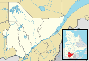 Baie-Saint-Paul Location in central Quebec. | |
| Coordinates: 47°27′N 70°30′W[1] | |
| Country | |
| Province | |
| Region | Capitale-Nationale |
| RCM | Charlevoix |
| Constituted | January 3, 1996 |
| Government | |
| • Mayor | Jean Fortin |
| • Federal riding | Beauport—Côte-de-Beaupré—Île d'Orléans—Charlevoix |
| • Prov. riding | Charlevoix–Côte-de-Beaupré |
| Area | |
| • City | 563.70 km2 (217.65 sq mi) |
| • Land | 546.48 km2 (211.00 sq mi) |
| • Urban | 5.99 km2 (2.31 sq mi) |
| Population (2016)[4] | |
| • City | 7,146 |
| • Density | 13.1/km2 (34/sq mi) |
| • Urban | 4,535 |
| • Urban density | 760.0/km2 (1,968/sq mi) |
| • Pop 2011-2016 | |
| • Dwellings | 3,231 |
| Time zone | UTC−5 (EST) |
| • Summer (DST) | UTC−4 (EDT) |
| Postal code(s) | G3Z |
| Area code(s) | 418 and 581 |
| Highways | |
| Website | www |
The place gained some prominence in the 1770s when Doctor Philippe-Louis-François Badelard named a disease he was researching the "Baie-Saint-Paul maladie". This illness was the subject of one of the first medical publications done in Lower Canada. It is also where Cirque du Soleil originated back in the early 1980s and the location of the first show using the name Cirque du Soleil during "La Fete Foraine de Baie-Saint-Paul" in 1984.
A visitor in the early 1800s noticed mineral springs and mineral resources in the area.[5]
Demographics
Population trend:[6]
- population in 2016: 7,146 (2011 to 2016 population change: -2.5%)
- Population in 2011: 7,332 (2006 to 2011 population change: 0.6%)
- Population in 2006: 7,288 (2001 to 2006 population change: 0.6%)
- Population in 2001: 7,290 (1996 to 2001 population change: -2.2%)
- Population in 1996: 7,379 (1991 to 1996 population change: 0.7%)
- Baie-Saint-Paul (ville): 3,569
- Baie-Saint-Paul (parish): 2,412
- Rivière-du-Gouffre (municipality): 1,398
- Population in 1991: 7,321
- Baie-Saint-Paul (ville): 3,733
- Baie-Saint-Paul (parish): 2,297
- Rivière-du-Gouffre (municipality): 1,305
Private dwellings occupied by usual residents: 3,187 (total dwellings: 3,617)
Mother tongue:
- English as first language: 0.2%
- French as first language: 98.7%
- English and French as first language: 0%
- Other as first language: 1.1%
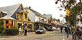
Street views of Baie-Saint-Paul

Climate
Baie-Saint Paul has a humid continental climate with vast seasonal differences. Summers are mild and moderated by its proximity to the Gulf of Saint Lawrence. In winter, interior Canada influences the climate with frequent cold waves.
| Climate data for Baie-Saint-Paul | |||||||||||||
|---|---|---|---|---|---|---|---|---|---|---|---|---|---|
| Month | Jan | Feb | Mar | Apr | May | Jun | Jul | Aug | Sep | Oct | Nov | Dec | Year |
| Record high °C (°F) | 11.0 (51.8) |
12.0 (53.6) |
16.0 (60.8) |
30.0 (86.0) |
35.5 (95.9) |
33.9 (93.0) |
35.6 (96.1) |
34.0 (93.2) |
33.0 (91.4) |
25.0 (77.0) |
18.5 (65.3) |
13.5 (56.3) |
35.6 (96.1) |
| Average high °C (°F) | −6.9 (19.6) |
−4.5 (23.9) |
0.7 (33.3) |
7.4 (45.3) |
15.6 (60.1) |
21.2 (70.2) |
23.9 (75.0) |
22.5 (72.5) |
17.3 (63.1) |
10.8 (51.4) |
3.5 (38.3) |
−3.8 (25.2) |
9.0 (48.2) |
| Daily mean °C (°F) | −12.5 (9.5) |
−10.2 (13.6) |
−4.4 (24.1) |
2.9 (37.2) |
10.1 (50.2) |
15.6 (60.1) |
18.5 (65.3) |
17.1 (62.8) |
12.2 (54.0) |
6.3 (43.3) |
−0.5 (31.1) |
−8.7 (16.3) |
3.9 (39.0) |
| Average low °C (°F) | −18.2 (−0.8) |
−16 (3) |
−9.5 (14.9) |
−1.6 (29.1) |
4.5 (40.1) |
10.0 (50.0) |
12.9 (55.2) |
11.7 (53.1) |
7.1 (44.8) |
1.8 (35.2) |
−4.4 (24.1) |
−13.5 (7.7) |
−1.3 (29.7) |
| Record low °C (°F) | −36 (−33) |
−34.4 (−29.9) |
−32 (−26) |
−18 (0) |
−6.7 (19.9) |
−0.5 (31.1) |
2.8 (37.0) |
0.5 (32.9) |
−5 (23) |
−9 (16) |
−23.9 (−11.0) |
−33 (−27) |
−36 (−33) |
| Average precipitation mm (inches) | 74.1 (2.92) |
63.0 (2.48) |
83.5 (3.29) |
94.6 (3.72) |
95.5 (3.76) |
94.7 (3.73) |
86.3 (3.40) |
85.9 (3.38) |
83.4 (3.28) |
80.3 (3.16) |
79.1 (3.11) |
78.8 (3.10) |
999.3 (39.34) |
| Average rainfall mm (inches) | 14.0 (0.55) |
12.7 (0.50) |
39.2 (1.54) |
76.1 (3.00) |
95.0 (3.74) |
94.7 (3.73) |
86.3 (3.40) |
85.9 (3.38) |
83.4 (3.28) |
78.5 (3.09) |
53.0 (2.09) |
9.4 (0.37) |
728.0 (28.66) |
| Average snowfall cm (inches) | 60.2 (23.7) |
50.4 (19.8) |
44.3 (17.4) |
17.1 (6.7) |
0.5 (0.2) |
0 (0) |
0 (0) |
0 (0) |
0 (0) |
1.7 (0.7) |
26.1 (10.3) |
69.4 (27.3) |
269.8 (106.2) |
| Average precipitation days (≥ 0.2 mm) | 9.7 | 7.1 | 9.4 | 10.3 | 11.7 | 12.5 | 13.1 | 13.3 | 11.1 | 10.9 | 9.6 | 10.5 | 129.3 |
| Average rainy days (≥ 0.2 mm) | 1.5 | 1.0 | 4.1 | 8.9 | 11.7 | 12.5 | 13.1 | 13.3 | 11.1 | 10.7 | 6.3 | 1.9 | 96.2 |
| Average snowy days (≥ 0.2 cm) | 8.9 | 6.3 | 6.3 | 2.6 | 0.07 | 0 | 0 | 0 | 0 | 0.41 | 3.9 | 9.4 | 37.8 |
| Source: Environment Canada[7] | |||||||||||||
See also
- 1925 Charlevoix–Kamouraska earthquake
- Charlevoix tourist train
References
- Reference number 313455 of the Commission de toponymie du Québec (in French)
- Ministère des Affaires municipales, des Régions et de l'Occupation du territoire - Répertoire des municipalités: Baie-Saint-Paul Archived 2011-01-08 at the Wayback Machine
- Statistics Canada 2011 Census - Baie-Saint-Paul census profile
- Statistics Canada 2016 Census - Petite-Rivière-Saint-François census profile
- Baddeley, Frederick Henry (1831). "Additional notes on the Geognosy of St. Paul's Bay". Transactions (Original Series). Literary and Historical Society of Quebec. 2. Archived from the original on May 3, 2013. Retrieved April 27, 2013.
- Statistics Canada: 1996, 2001, 2006, 2011, 2016
- Environment Canada—Canadian Climate Normals 1971-2000. Retrieved April 6, 2012.
External links
| Wikivoyage has a travel guide for Baie St-Paul. |
| Wikimedia Commons has media related to Baie-Saint-Paul, Quebec. |
Places adjacent to Baie-Saint-Paul | ||||||||||
|---|---|---|---|---|---|---|---|---|---|---|
| ||||||||||
| Cities & towns | |
|---|---|
| Municipalities |
|
| Parishes | |
| Unorganized territories | |
| |