Lac-Jacques-Cartier, Quebec
Lac-Jacques-Cartier is a large unorganized territory in the Capitale-Nationale region of Quebec, Canada, in the La Côte-de-Beaupré Regional County Municipality, making up more than 85% of this regional county. It is unpopulated and undeveloped, almost entirely part of the Jacques-Cartier National Park and the Laurentides Wildlife Reserve.
Lac-Jacques-Cartier | |
|---|---|
Unorganized territory | |
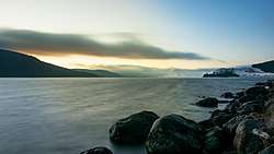 Lake Jacques Cartier | |
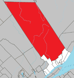 Location within La Côte-de-Beaupré RCM | |
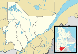 Lac-Jacques-Cartier Location in central Quebec | |
| Coordinates: 47°35′N 71°13′W[1] | |
| Country | Canada |
| Province | Quebec |
| Region | Capitale-Nationale |
| RCM | La Côte-de-Beaupré |
| Constituted | January 1, 1986 |
| Government | |
| • Federal riding | Montmorency—Charlevoix —Haute-Côte-Nord |
| • Prov. riding | Charlevoix–Côte-de-Beaupré |
| Area | |
| • Total | 4,286.40 km2 (1,654.99 sq mi) |
| • Land | 4,151.18 km2 (1,602.78 sq mi) |
| Population (2016)[3] | |
| • Total | 0 |
| • Density | 0.0/km2 (0/sq mi) |
| Time zone | UTC−5 (EST) |
| • Summer (DST) | UTC−4 (EDT) |
| Highways | |
Quebec Route 175 bisects the territory, and passes on the western shore of Lake Jacques-Cartier, after which the territory is named and source of the Jacques-Cartier River.
Demographics
Population trend:[4]
- Population in 2016: 0
- Population in 2011: 0
- Population in 2006: 0
- Population in 2001: 0
- Population in 1996: 0
- Population in 1991: 3
References
- Reference number 149588 of the Commission de toponymie du Québec (in French)
- Ministère des Affaires municipales, des Régions et de l'Occupation du territoire - Répertoire des municipalités: Lac-Jacques-Cartier
- "(Code 2421904) Census Profile". 2016 census. Statistics Canada. 2017.
- Statistics Canada: 1996, 2001, 2006, 2011 census
External links
![]()
Adjacent Municipal Subdivisions | |
|---|---|
| Cities & towns | |
|---|---|
| Municipalities | |
| Parishes | |
| Unorganized territories | |
| |
This article is issued from Wikipedia. The text is licensed under Creative Commons - Attribution - Sharealike. Additional terms may apply for the media files.