Autopista A1 (Cuba)
The Autopista A1, also known as Autopista Nacional, is a Cuban motorway, partly built, that will link Havana to Guantánamo.[2] It is a toll-free road and its total length will be of about 900 km (560 mi). Along with the Autopista A4, linking Havana to Pinar del Río, it is classified as part of the whole Autopista Nacional route,[3] spanning the length of the island; as the Carretera Central highway.
| |
|---|---|
| Autopista Nacional | |
| National Motorway | |
.png) Map of the Cuban motorway network | |
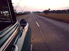 View of the A1 in Havana | |
| Route information | |
| Length | 900 km (600 mi) |
| Existed | 1979–present |
| Major junctions | |
| West end | Havana |
| East end | Guantánamo |
| Location | |
| Major cities | Havana, San José de las Lajas, Güines, Jagüey Grande, Aguada de Pasajeros, Santa Clara, Placetas, Cabaiguán, Sancti Spíritus, Jatibonico, Ciego de Ávila, Florida, Camagüey, Guáimaro, Las Tunas, Holguín, Bayamo,[1] Contramaestre, Palma Soriano, San Luis, Santiago de Cuba, La Maya, Guantánamo |
| Highway system | |
| Roads in Cuba | |


.jpg)
History
The motorway, connected to the A4 via the Havana Ringroad (A2), was opened in 1979 from Havana to Santa Clara. Additional sections (2 in the Oriental region) were opened during the 1980s, but further work was interrupted in 1990 as the economic crisis of the "Special Period" (Spanish: Período especial) developed.[3]
Route
The A1, the longest motorway of the island, is a dual carriageway with 6 lanes (8 from Havana to San José de las Lajas), and has some at-grade intersections with rural roads. The operating sections are[4][2] the Havana-Santa Clara-Sancti Spíritus-Taguasco (354 km, main section), Palma Soriano-Santiago de Cuba (53 km) and La Maya-Guantánamo (41 km, sharing the Carretera Central route for 9 km).
From the exit "Santa Clara-Manicaragua" to Taguasco, the A1 operates with a single carriageway, and from Taguasco to Jatibonico, it is under construction. Other sections under construction, both in Santiago de Cuba Province, are the one from Contramaestre to Palma Soriano, and the one from La Maya to the Palma-Santiago section, ending with the construction of a future interchange. The other section, passing through the provinces of Ciego de Ávila, Camagüey, Las Tunas, Holguín and Granma, has been planned.[3]
| AUTOPISTA A1 (Autopista Nacional) | |||||
| Exit | ↓km↓ | Province | Note | ||
|---|---|---|---|---|---|
| 0.0 | Havana | ||||
| 0.4 | Havana | ||||
| 2.1 | Havana | ||||
| 4.6 | Havana | ||||
(link to | 6.1 | Havana | |||
| 8.3 | Havana | ||||
| 12.2 | Havana | ||||
| 18.5 | Mayabeque | ||||
(Jamaica - Universidad Agraria) | 22.6 | Mayabeque | |||
(to San José de las Lajas south) | 28.2 | Mayabeque | |||
(to Madruga and the Carretera Central) | 31.2 | Mayabeque | |||
| 42.8 | Mayabeque | ||||
| 51.2 | Mayabeque | ||||
Rest area "Paladar de Daisy" (westbound) | 54.1 | Mayabeque | |||
| 59.8 | Mayabeque | ||||
(to San Nicolás) | 63.0 | Mayabeque | |||
| 71.0 | Mayabeque | ||||
| 79.0 | Mayabeque | ||||
| 91.0 | Matanzas | ||||
| 104.0 | Matanzas | ||||
| 127.0 | Matanzas | ||||
(road to Varadero via Jovellanos and Cárdenas) | 135.0 | Matanzas | |||
| 141.2 | Matanzas | ||||
(to the Ciénaga de Zapata) | 141.2 | Matanzas | |||
| 164.0 | Matanzas | ||||
| 171.8 | Cienfuegos | ||||
(to Cienfuegos) | 172.0 | Cienfuegos | |||
| 183.0 | Cienfuegos | ||||
| 206.0 | Cienfuegos | ||||
| 213.0 | Cienfuegos | ||||
| 213.0 | Cienfuegos | ||||
| 232.0 | Cienfuegos | ||||
(to Cienfuegos) | 249.0 | Villa Clara | |||
( | 261.0 | Villa Clara | |||
| 270.0 | Villa Clara | ||||
| 296.0 | Villa Clara | 1 cgw. | |||
| 302.0 | Villa Clara | 1 cgw. | |||
(Carretera Central) | 323.0 | Sancti Spíritus | 1 cgw. | ||
| 329.0 | Sancti Spíritus | 1 cgw. | |||
| 332.0 | Sancti Spíritus | 1 cgw. | |||
( | 336.0 | Sancti Spíritus | |||
| 343.0 | Sancti Spíritus | 1 cgw. | |||
| 349.0 | Sancti Spíritus | 1 cgw. | |||
| 354.0 | Sancti Spíritus | 1 cgw. | |||
| 365.0 | Sancti Spíritus | ||||
| Jatibonico–Camagüey–Holguín–Contramaestre section (planned: listed possible future exits) | |||||
| Ciego de Ávila | |||||
| Ciego de Ávila | |||||
(to Morón) | 407 (ca.) | Ciego de Ávila | |||
| Ciego de Ávila | |||||
| Ciego de Ávila | |||||
| Camagüey | |||||
| Camagüey | |||||
| Camagüey | |||||
| 512 (ca.) | Camagüey | ||||
| Camagüey | |||||
| Camagüey | |||||
| Camagüey | |||||
| Camagüey | |||||
| Camagüey | |||||
| Las Tunas | |||||
| 620 (ca.) | Las Tunas | ||||
| Las Tunas | |||||
| Las Tunas | |||||
| Holguín | |||||
(possible ringroad to Holguín city center) | 673 (ca.) | Holguín | |||
| Holguín | |||||
| Granma | |||||
(to Manzanillo, possible ringroad to Bayamo city center) | 713 (ca.) | Granma | |||
| Granma | |||||
| Contramaestre–Palma–San Luis–Santiago section | |||||
| 0.0 (738 ca.) | Santiago | ||||
| 5.9 | Santiago | ||||
| 18.2 | Santiago | ||||
| 22.9 | Santiago | ||||
| 29.2 | Santiago | 1 cgw. | |||
| 32.2 (770 ca.) | Santiago | 1 cgw. | |||
| 39.1 | Santiago | 1 cgw. | |||
| 44.6 (782 ca.) | Santiago | ||||
(Carretera Central) | 52.7 | Santiago | |||
| 54.0 (792 ca.) | Santiago | ||||
(to Guantánamo and Alto Songo) | 59.6 | Santiago | |||
| 66.3 | Santiago | ||||
| 68.2 | Santiago | ||||
( | 70.3 (808 ca.) | Santiago | |||
| 71.5 | Santiago | ||||
| 72.7 | Santiago | ||||
| 75.0 | Santiago | ||||
| 76.7 | Santiago | ||||
| 78.4 | Santiago | ||||
| 82.3 (820 ca.) | Santiago | ||||
| San Luis–La Maya–Guantánamo section | |||||
| 0.0 (792 ca.) | Santiago | ||||
| 4.9 | Santiago | ||||
| 8.4 | Santiago | ||||
| 14.4 | Santiago | ||||
| 20.7 (813 ca.) | Santiago | 1 cgw. | |||
| 25.0 | Santiago | 1 cgw. | |||
| 28.6 | Santiago | 1 cgw. | |||
| 34.8 | Santiago | 1 cgw. | |||
| 38.5 | Santiago | CC route | |||
| 42.8 | Guantánamo | CC route | |||
| 47.7 | Guantánamo | CC route | |||
| 59.2 | Guantánamo | ||||
| 61.5 (853 ca.) | Guantánamo | ||||
References
- A1 project through Granma and Holguín provinces is yet undefined
- Source: Mapa de Carreteras de Cuba (Road map of Cuba). Ediciones GEO, Havana 2011 - ISBN 959-7049-21-X
- (in Spanish) Autopista Nacional on EcuRed
- Satellite images of Cuba at Google Maps
External links
![]()