Athée-sur-Cher
Athée-sur-Cher is a commune in the Indre-et-Loire department in central France.
Athée-sur-Cher | |
|---|---|
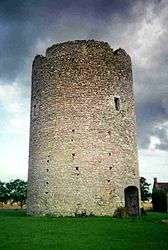 The Tower of Brandon, in Athée-sur-Cher | |
.svg.png) Coat of arms | |
Location of Athée-sur-Cher 
| |
 Athée-sur-Cher  Athée-sur-Cher | |
| Coordinates: 47°19′18″N 0°54′59″E | |
| Country | France |
| Region | Centre-Val de Loire |
| Department | Indre-et-Loire |
| Arrondissement | Loches |
| Canton | Bléré |
| Intercommunality | CC Bléré Val Cher |
| Government | |
| • Mayor (2014-2020) | Jean-Jacques Martin |
| Area 1 | 34.47 km2 (13.31 sq mi) |
| Population (2017-01-01)[1] | 2,673 |
| • Density | 78/km2 (200/sq mi) |
| Time zone | UTC+01:00 (CET) |
| • Summer (DST) | UTC+02:00 (CEST) |
| INSEE/Postal code | 37008 /37270 |
| Elevation | 49–104 m (161–341 ft) |
| 1 French Land Register data, which excludes lakes, ponds, glaciers > 1 km2 (0.386 sq mi or 247 acres) and river estuaries. | |
Population
| Historical population | ||
|---|---|---|
| Year | Pop. | ±% |
| 1793 | 1,246 | — |
| 1800 | 1,340 | +7.5% |
| 1806 | 1,214 | −9.4% |
| 1821 | 1,239 | +2.1% |
| 1831 | 1,304 | +5.2% |
| 1836 | 1,381 | +5.9% |
| 1841 | 1,356 | −1.8% |
| 1846 | 1,492 | +10.0% |
| 1851 | 1,373 | −8.0% |
| 1856 | 1,402 | +2.1% |
| 1861 | 1,455 | +3.8% |
| 1866 | 1,441 | −1.0% |
| 1872 | 1,373 | −4.7% |
| 1876 | 1,342 | −2.3% |
| 1881 | 1,377 | +2.6% |
| 1886 | 1,367 | −0.7% |
| 1891 | 1,327 | −2.9% |
| 1896 | 1,249 | −5.9% |
| 1901 | 1,157 | −7.4% |
| 1906 | 1,148 | −0.8% |
| 1911 | 1,145 | −0.3% |
| 1921 | 1,066 | −6.9% |
| 1926 | 1,044 | −2.1% |
| 1931 | 1,011 | −3.2% |
| 1936 | 1,013 | +0.2% |
| 1946 | 1,059 | +4.5% |
| 1954 | 1,012 | −4.4% |
| 1962 | 1,094 | +8.1% |
| 1968 | 1,063 | −2.8% |
| 1975 | 1,256 | +18.2% |
| 1982 | 1,506 | +19.9% |
| 1990 | 1,819 | +20.8% |
| 1999 | 2,019 | +11.0% |
| 2006 | 2,313 | +14.6% |
| 2009 | 2,440 | +5.5% |
| 2015 | 2,674 | +9.6% |
References
- "Populations légales 2017". INSEE. Retrieved 6 January 2020.
| Wikimedia Commons has media related to Athée-sur-Cher. |
| Authority control |
|
|---|
This article is issued from Wikipedia. The text is licensed under Creative Commons - Attribution - Sharealike. Additional terms may apply for the media files.