Arlington Heights, Los Angeles
Arlington Heights is a neighborhood in Central Los Angeles, California.
Arlington Heights | |
|---|---|
Neighborhood of Los Angeles | |
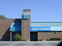
 Arlington Heights neighborhood sign located at the intersection of Arlington Avenue and Washington Boulevard | |
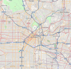 Arlington Heights Location in Central Los Angeles | |
| Coordinates: 34°02′32″N 118°19′08″W | |
| Country | United States |
| State | California |
| City | Los Angeles |
Geography
Per Council File: 02-2353, adopted on October 30, 2002, the City of Los Angeles defined Arlington Heights as the area bounded by the west side of Arlington Avenue, the east side of Crenshaw Boulevard, the north side of Washington Boulevard and the south side of Pico Boulevard. [1] At that time, The Los Angeles Department of Transportation was instructed to install neighborhood signs at the following locations: Arlington and Pico Boulevard (southwest corner), Arlington Avenue and Washington Boulevard (northeast corner), Crenshaw and Washington Boulevards (northeast corner), Crenshaw and Venice Boulevards (southeast corner), Crenshaw and Pico Boulevards (southeast corner), Arlington Avenue and Venice Boulevard (northwest corner). [1]
The neighborhood of Country Club Park is located north of Pico Boulevard. Angelus Vista is located east of Arlington Avenue. The neighborhoods of Victoria Park and Lafayette Square are located west of Crenshaw Boulevard.
The Los Angeles Times Mapping L.A.project definition of Arlington Heights includes the adjacent neighborhoods of Country Club Park, Western Heights [2] and Angelus Vista. This larger area is bounded on the north by Olympic Boulevard, on the east by Gramercy Place, on the south by the Santa Monica Freeway and on the west by Crenshaw Boulevard.[2][3]

Population
The following statistics apply only to the area defined by the Los Angeles Times Mapping L.A. project:
The 2000 U.S. census counted 22,096 residents in the 1.03-square-mile neighborhood—an average of 21,423 people per square mile, among the highest population densities in the county. In 2008, the city estimated that the population had increased to 23,330. The median age for residents was 31, about average for both the city and the county.[2]
Arlington Heights was said to be "highly diverse"[4] when compared to the city at large. The ethnic breakdown in 2000 was: Latinos, 56.6%; blacks, 24.5%; Asians, 12.9%; whites, 4.7%; and others, 1.2%. Mexico (34,9%) and El Salvador (20.2%) were the most common places of birth for the 49.8% of the residents who were born abroad, a figure that was considered high in comparison with foreign-born in the city as a whole.[2]
The median household income in 2008 dollars was $31,421, considered low for both the city and the county. The percentage of households earning $20,000 or less was high, compared to the county at large. The household size of three people was just about average for Los Angeles. Renters occupied 81.6% of the housing units, and home- or apartment owners the rest.[2]
The percentages of never-married men (42.4%) and never-married women (35.9%) were among the county's highest. The census found 1,165 families headed by single parents, the 23.5% rate being considered high for both the city and the county.[2]
Education
The following statistics apply only to the area defined by the Los Angeles Times Mapping L.A. project:
Arlington Heights residents aged 25 and older holding a four-year degree amounted to 13.9% of the population in 2000, about average for both the city and the county, although there was a high percentage of residents with less than a high school diploma.[2]
Public Schools
- Los Angeles Technology Center, LAUSD adult education, 3721 Washington Boulevard
- Johnnie L. Cochran Jr. Middle School, LAUSD, 4066 West Johnnie Cochran Vista
- Arlington Heights Elementary School, LAUSD, 1717 Seventh Avenue
Landmarks and attractions
- Jewel's Catch One - Opened in 1973 on Pico Boulevard, two blocks east of Crenshaw Boulevard, it was the nation's first black gay and lesbian disco.[5] Since 2015, it has operated as a more traditional nightclub with an array of live DJ sets and performances by house music and rap artists.
Public libraries
The neighborhood is served by the Los Angeles Public Library system. There is one branch that serves Arlington Heights.
- Washington Irving - located at 4117 West Washington Boulevard, just east of Crenshaw Boulevard.
Notable residents
See also
- List of Registered Historic Places in Los Angeles
- List of Los Angeles Historic-Cultural Monuments in South Los Angeles
- List of districts and neighborhoods in Los Angeles
References
- "Arlington Heights". LAcity.org. Retrieved 24 April 2020.
- "Arlington Heights," Mapping L.A., Los Angeles Times
- "Central L.A.," Mapping L.A., Los Angeles Times
- Diversity "measures the probability that any two residents, chosen at random, would be of different ethnicities. If all residents are of the same ethnic group it's zero. If half are from one group and half from another it's .50." —Los Angeles Times
- Anderson, Tre'vell. "A new documentary explores the roots of Jewel's Catch One, one of L.A.'s first black gay discos - Los Angeles Times". latimes.com.
- "Former Councilman and Supervisor Hanley Dies," Los Angeles Times, April 4, 1916, page II-1
- Location of the Hanley home on Mapping L.A.
External links
- United Neighborhoods Council
- WAHA West Adams Heritage Association
- Arlington Heights crime map and statistics
| Wikimedia Commons has media related to Arlington Heights, Los Angeles. |
Places adjacent to Arlington Heights, Los Angeles | ||||||||||
|---|---|---|---|---|---|---|---|---|---|---|
| ||||||||||
| By topic |  | |
|---|---|---|
| Government | ||
| Districts and neighborhoods |
|  |
|---|---|---|
| Points of interest | ||