Vithura
Vithura is a village situated 37 km from Thiruvananthapuram, capital of the Kerala state in India.[3] Vithura is the crossroads to various tourist, cultural, and religious centres. Surrounded by the Western Ghats (Sahyadri), Vithura is a prime tourist spot. The Village is rich with scenic beauty and good climate. The campus for the Indian Institute of Science Education and Research, Thiruvananthapuram is being constructed here.
Vithura | |
|---|---|
Village | |
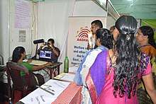
.jpg) Vithura Grama Panchayat Office | |
 Vithura Location in Kerala, India  Vithura Vithura (India) | |
| Coordinates: 8.6818°N 77.1022°E | |
| Country | |
| State | Kerala |
| District | Thiruvananthapuram |
| Talukas | Nedumangad |
| Government | |
| • Body | Gram panchayat |
| Population (2011) | |
| • Total | 18,437 [1] |
| Languages | |
| • Official | Malayalam, English |
| Time zone | UTC+5:30 (IST) |
| PIN | 695551[2] |
| Vehicle registration | KL-21 |
| Nearest city | Thiruvananthapuram |
| Lok Sabha constituency | Attingal |
Demography
Vithura is a large village located in Nedumangad Taluka of Thiruvananthapuram district, Kerala with total 5163 families residing. Population of Vithura counts 18437 persons of which 8680 are males while 9757 are females as per Population Census 2011. Vithura village has lower literacy rate compared to Kerala. In 2011, literacy rate of Vithura village was 88.64 % compared to 94.00 % of Kerala. In Vithura Male literacy stands at 92.18 % while female literacy rate was 85.54 %. Schedule Tribe (ST) constitutes 18.17 % while Schedule Caste (SC) were 12.37 % of total population in Vithura village. [1] The 2001 census reported a population of 26,927. [4]
Places of worship
The following are some of the places of worship in Vithura:
- CSI CHURCH Vithura
- Sri Mahaganapathi Temple Maruthamala Vithura
- Makki Sri Dharmasastha Kshethram Vithura
- The Pentecostal Mission Vithura (TPM)
- Sree Krishnaswami Temple
- Sri Bhadrakali Devi Temple, at Chayam Vithura
- Sri Mahadeva devi Temple, at Sivan Kovil Vithura
- All Saints Syro Malabar Church, at Koppam Vithura
- St. Mary's Malankara Catholic Church Vithura
- St. Joseph Latin Catholic Church Vithura
- Sri Bhadrakali Devi Temple (Kulamancode), at Pulichamala
- Muhiyudheen Jumah Masjid
- St. George Orthodox Church
Educational institutions
- Govt LPS Vithura
- Govt UPS Vithura
- Govt HS Vithura
- Govt VHSC Vithura
- Govt welfare school maruthamala
- All Saints Public School And Junior College
- MGM Ponmudi Valley Public School
- Indian Institute of Science Education and Research, Thiruvananthapuram
- Indian Institute of Space Science and Technology, near Vithura
- Govt LPS Chayam Vithura
Hospitals
- Govt Public Health Center Vithura (Taluk Hospital)
Tourist spots
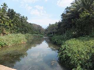
There are several rubber plantations. Prominent tourist spots include Ponmudi, Peppara Dam, Meenmutty Falls, Bonacaud and Agastyakoodam. A stones throw away from Vithura lies Iruthalamoola Junction in the Tholicode Panchayath. Iru in Malayalam means two and Thala means head and moola means corner. Perhaps the place got its name because the Trivandrum to Ponmudi and Vithura to Aryanad roads meet at Eruthalamoola Junction. Perched on a hill very close to Iruthalamoola stands a massive magnificent rock called Chittiparra. Chittiparra is frequented by adventure type tourists keen on the challenges of rock climbing. Lush green paddy fields, rubber plantations, coconut gardens abound in scenic Vithura which is a hot spot for the thousands of tea plantation workers who work in the hills. A visit to the rubber plantations, including the local kalaris (Traditional Martial Arts Schools) is a must to every visitor.[5]
- Ponmudi Hill Resorts
- Bonacaud Tea Gardens
- Vayuvanthole Water Falls
- Meenmutty Water falls
- Thavakkal Water Fall
- Peppara Dam
- Peppara Hydro Electric Power Station
- Thavakkal water fall
- Golden valley
- Kallar River
- Pandi pathu
References
- "2011 Census of India". Registrar General & Census Commissioner, India. Retrieved 4 May 2019.
- "India Post :Pincode Search". Indiapost.gov.in. Retrieved 16 December 2008.
- "Yahoo Maps India : Vithura". In.maps.yahoo.com. Retrieved 18 December 2008.
- "Census of India : Villages with population 5000 & above". Registrar General & Census Commissioner, India. Retrieved 10 December 2008.
- Archived 29 June 2007 at the Wayback Machine
District HQ: Thiruvananthapuram | |||||||
| History | 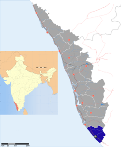 | ||||||
| Geography | |||||||
| Cities and Taluks |
| ||||||
| Transport | |||||||
| Education |
| ||||||
| Buildings | |||||||
| Culture | |||||||
| Lok Sabha constituencies | |||||||
| Sports |
| ||||||
| Museums | |||||||