Záhony
| Záhony | ||
|---|---|---|
 | ||
| ||
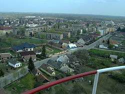
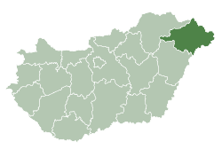
 Záhony Location of Záhony | ||
| Coordinates: 48°25′01″N 22°10′59″E / 48.417°N 22.183°E | ||
| Country |
| |
| County | Szabolcs-Szatmár-Bereg | |
| Area | ||
| • Total | 6.87 km2 (2.65 sq mi) | |
| Population (2015)[1] | ||
| • Total | 4,156 | |
| • Density | 600/km2 (1,600/sq mi) | |
| Time zone | UTC+1 (CET) | |
| • Summer (DST) | UTC+2 (CEST) | |
| Postal code | 4625 | |
| Area code(s) | 45 | |
| Website |
www | |

Záhony (Ukrainian: Загонь) is a town in Szabolcs-Szatmár-Bereg county, in the Northern Great Plain region of eastern Hungary.
It covers an area of 6.97 km2 (3 sq mi) and has a population of 4675 people (2005). It is near the Ukrainian border (at Chop and Solomonovo) and was part of Ung county before Trianon Treaty. Road and railway border crossings into Ukraine are located here. The Ukrainian town across the border is Chop.
International relations
Twin towns — Sister cities
Záhony is twinned with:

Gallery
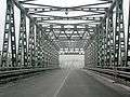 The Tysa bridge at the Chop-Záhony checkpoint (view from the Ukrainian side).
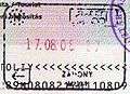 Passport stamp from Záhony.
References
- ↑ Gazetteer of Hungary, 1st January 2015. Hungarian Central Statistical Office.

Coordinates: 48°25′N 22°11′E / 48.417°N 22.183°E
| Wikimedia Commons has media related to Záhony. |
This article is issued from
Wikipedia.
The text is licensed under Creative Commons - Attribution - Sharealike.
Additional terms may apply for the media files.