Nyírtelek
| Nyírtelek | ||
|---|---|---|
| ||
| Country |
| |
| County | Szabolcs-Szatmár-Bereg | |
| Area | ||
| • Total | 67.92 km2 (26.22 sq mi) | |
| Population (2005) | ||
| • Total | 7,114 | |
| • Density | 105.21/km2 (272.5/sq mi) | |
| Time zone | UTC+1 (CET) | |
| • Summer (DST) | UTC+2 (CEST) | |
| Postal code | 4461 | |
| Area code(s) | 42 | |
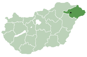
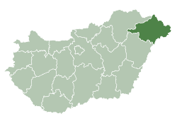
Location of Szabolcs-Szatmar-Bereg county in Hungary
Nyírtelek is a town in Szabolcs-Szatmár-Bereg county, in the Northern Great Plain region of eastern Hungary.
History
The town was separated from Nyíregyháza and became an independent settlement in January 1952 under the name Sőrekút. It was renamed to its current name still in that year, in November 1952.
Geography
It covers an area of 67.92 km2 (26 sq mi) and has a population of 7114 people (2005).
This article is issued from
Wikipedia.
The text is licensed under Creative Commons - Attribution - Sharealike.
Additional terms may apply for the media files.