Botpalád
| Botpalád | ||
|---|---|---|
| ||
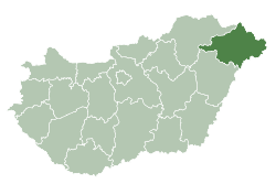
 Botpalád Location of Botpalád in Hungary | ||
| Coordinates: 48°02′N 22°48′E / 48.03°N 22.8°ECoordinates: 48°02′N 22°48′E / 48.03°N 22.8°E | ||
| Country | Hungary | |
| Region | Northern Great Plain | |
| County | Szabolcs-Szatmár-Bereg | |
| Area[1] | ||
| • Total | 16.5 km2 (6.4 sq mi) | |
| Population (2013)[2] | ||
| • Total | 654 | |
| • Density | 40/km2 (100/sq mi) | |
| Time zone | UTC+1 (CET) | |
| • Summer (DST) | UTC+2 (CEST) | |
| Postal code | 4955 | |
| Area code | +36 44 | |
Botpalád is a village in Szabolcs-Szatmár-Bereg county,[3] in the Northern Great Plain region of eastern Hungary.
Geography
It covers an area of 16.5 km2 (6 sq mi) and has a population of 654 people (2013 estimate).[2]
Population
| Year | 1980 | 1990 | 2001 | 2010 | 2011 | 2013 |
|---|---|---|---|---|---|---|
| Population | 671 (census)[2] | 546 (census)[2] | 583 (census)[2] | 605 (estimate)[4] | 610 (census)[2] | 654 (estimate)[2] |
References
- ↑ Botpalád at the Hungarian Central Statistical Office (Hungarian).
- 1 2 3 4 5 6 7 "Botpalád Population Table". Retrieved 4 January 2014.
- ↑ "Botpalád City Info". CitySeek.org. Retrieved 4 January 2014.
- ↑ "Helységnévkönyv adattár 2010". KSH (Hungarian Central Statisctical Office). 1 January 2010. Archived from the original on 7 November 2012. Retrieved 4 January 2014.

This article is issued from
Wikipedia.
The text is licensed under Creative Commons - Attribution - Sharealike.
Additional terms may apply for the media files.