Zaca Fire
| Zaca Fire | |
|---|---|
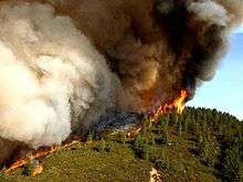 Active flame front of the fire. | |
| Location |
San Rafael Mountains, Los Padres National Forest, Santa Barbara County, California |
| Coordinates | 34°42′57″N 119°46′58″W / 34.7159°N 119.7828°WCoordinates: 34°42′57″N 119°46′58″W / 34.7159°N 119.7828°W |
| Statistics[1] | |
| Cost | $118.3 million (2017 USD) |
| Date(s) | July 4, 2007 – October 29, 2007 |
| Burned area | 240,207 acres (972 km2) |
| Cause | Sparks from a grinding machine on private property |
| Buildings destroyed | 1 |
| Non-fatal injuries | 43 |
| Map | |
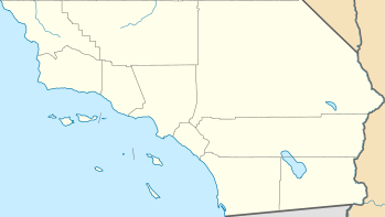 Location of fire in Southern California. | |
The Zaca Fire was a massive wildfire that began burning in the San Rafael Mountains, northeast of the Santa Ynez Valley in Santa Barbara County, California. It was also the single largest wildfire of the 2007 California wildfire season. The fire started on July 4, 2007, and by August 31, it had burned over 240,207 acres (972.083 km2), making it California's second largest fire in recorded history at that time after the Cedar Fire of 2003.[2][3] As of 2018, it is currently California's sixth-largest fire in recorded history.[4] The fire was contained on September 4, 2007,[5] with the fire being brought under control on October 29, 2007.[6]
The fire
On July 4, 2007, at 10:53 AM PDT, the Zaca Fire was started as a result of sparks from a grinding machine on private property, which was being used to repair a water pipe.[3][7][1] The Zaca Fire continued to expand in size, reaching 240,207 acres (972.08 km2) in August.[2][8]
By August 12, progress was being made on the fire through the combined efforts of firefighters and aircraft. Firefighters were able to turn the direction of the fire away from the Paradise Road community.[9]
The Zaca Fire neared containment on September 2.[5] On September 4, 2007, the fire had cost $117 million to fight, and was 100% contained.[1] Hotspots within the fire perimeter continued to burn for over another month, until the Zaca Fire was fully brought under control on October 29, 2007.[6]
Impacts
The fire had primarily burned away from populated areas in extremely steep and rugged areas of the San Rafael Mountains in the Los Padres National Forest and the Santa Ynez River Recreation Area.[2] It only destroyed one Forest Service outbuilding. Its impacts on the environment and area water resources are not yet fully known.[10] Many trails and campgrounds in the Dick Smith Wilderness were destroyed. Since then, a number of them have been rebuilt.
See also
References
- 1 2 3 "Zaca Fire Incident Information". CAL FIRE. 4 September 2007. Retrieved 25 August 2015.
- 1 2 3 Cal Fire update page
- 1 2 Zaca Fire information on Yuba net
- ↑ "Top 20 Largest California Wildfires" (PDF). CAL FIRE. 14 August 2018. Retrieved 15 August 2018.
- 1 2 "Zaca Wildland Fire". Retrieved 2007-09-03.
- 1 2 "Zaca Fire Controlled But Not Out" InciWeb. Retrieved on November 6, 2007
- ↑ "Officials Find Cause of Zaca Fire", KEYT3 news, July 6, 2007 Archived at Wayback Machine
- ↑ Giana Magnoli (December 13, 2017). "Earlier wildfires may hold key to stopping giant Thomas Fire". The Tribune. Retrieved December 14, 2017.
- ↑ Daniel, Stacy; Tina Leonard (August 12, 2007). "Critical turn in the Zaca Fire: DC-10 Airtanker flies over and Evacuation Order downgraded". KSBY-TV—San Luis Obispo, CA. MSNBC. Retrieved 2007-08-22.
- ↑ "Zaca Fire Impacts Will Linger for Years" by Ray Ford, Santa Barbara Independent. Retrieved on November 6, 2007
External links
| Wikimedia Commons has media related to Zaca Fire. |
- CDF—California Dept. Forestry: Maps of the Zaca Fire
- California Fire News: daily coverage of the "Zaca Fire" wildland fire including fire perimeter maps, photos - Over 100 pages labeled "Zaca Fire"
- Associated Press: "Giant fire in Los Padres forest to cross into Ventura County"
- Los Angeles Times - "Santa Barbara fire flares anew"
- Santa Maria Times - "Zaca Fire takes unexpected turn".
- Southern California's Worst Brush Fires
| Pre-2000 |
|
|---|---|
| 2002 | |
| 2003 | |
| 2004 | |
| 2005 | |
| 2006 | |
| 2007 | |
| 2008 | |
| 2009 | |
| 2010 | |
| 2011 | |
| 2012 | |
| 2013 | |
| 2014 | |
| 2015 | |
| 2016 | |
| 2017 | |
| 2018 | |
| |