Parker 2 Fire
| Parker 2 Fire | |
|---|---|
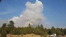 Parker 2 Fire on August 3, 2017 | |
| Location | Modoc National Forest, California, United States |
| Coordinates | 41°27′58″N 120°19′16″W / 41.466°N 120.321°WCoordinates: 41°27′58″N 120°19′16″W / 41.466°N 120.321°W |
| Statistics[1] | |
| Date(s) | August 3, 2017 – August 28, 2017 |
| Burned area | 7,697 acres (31 km2) |
| Map | |
 Location of fire in California. | |
The Parker 2 Fire was a wildfire in the Modoc National Forest in Modoc County, California in the United States. The fire, which was reported on August 3, 2017, burned a total of 7,697 acres (31 km2). It was fully contained by August 28. The cause for the fire was lightning.
Events
The Parker 2 Fire was first reported on August 3 at 2:00 pm. The fire was started by lightning and was fueled by grass, brush and timber.[1] As of August 4, the fire grew to 1,500 acres (6 km2). As a result, the Parker Creek area of the Warner Mountains was closed.[2]
The fire was contained, as of August 28, burning a total of 7,697 acres (31 km2).[1]
Impact
The Middle Fork Parker Creek Bridge was damaged by the fire. A temporary, portable bridge was provided by the Shasta-Trinity National Forest until a permanent solution is finalized.[1]
References
- 1 2 3 4 "Parker 2 Fire". Parker 2 Fire. United States Forest Service. Retrieved 4 September 2017.
- ↑ "New emergency fire closures on the Modoc National Forest". Mount Shasta Herald. Retrieved 5 September 2017.
| Wikimedia Commons has media related to Parker 2 Fire. |
| Pre-2000 |
|
|---|---|
| 2002 | |
| 2003 | |
| 2004 | |
| 2005 | |
| 2006 | |
| 2007 | |
| 2008 | |
| 2009 | |
| 2010 | |
| 2011 | |
| 2012 | |
| 2013 | |
| 2014 | |
| 2015 | |
| 2016 | |
| 2017 | |
| 2018 | |
| |