Young, New South Wales
| Young New South Wales | |||||||||
|---|---|---|---|---|---|---|---|---|---|
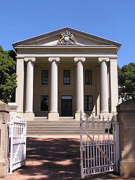 Young courthouse built in 1884 but transferred to the Department of Education in 1925 and used as the main hall of Young High School | |||||||||
 Young | |||||||||
| Coordinates | 34°18′0″S 148°18′0″E / 34.30000°S 148.30000°ECoordinates: 34°18′0″S 148°18′0″E / 34.30000°S 148.30000°E | ||||||||
| Population | 7,170 (2016 census)[1] | ||||||||
| Established | 1826 | ||||||||
| Postcode(s) | 2594 | ||||||||
| Elevation | 439 m (1,440 ft) | ||||||||
| Location | |||||||||
| LGA(s) | Hilltops Council | ||||||||
| State electorate(s) | Cootamundra | ||||||||
| Federal Division(s) | Riverina | ||||||||
| |||||||||
Young is a town in the South West Slopes region of New South Wales, Australia and the largest town in Hilltops Region. The "Lambing Flat" Post Office opened on 1 March 1861 and was renamed "Young" in 1863.[2]
Young is marketed as the Cherry Capital of Australia and every year hosts the National Cherry Festival. Young is situated on the Olympic Highway and is approximately 2 hours drive from the Canberra area. It is in a valley, with surrounding hills. The town is named after Sir John Young, the governor of NSW from 1861 to 1867.[3][4]
History
Before European settlers arrived in Young, members of the Burrowmunditory tribe, a family group of the indigenous Wiradjuri Nation, lived in the region.[5] Descendents of the Burrowmunditory clan still live in Young.[6]
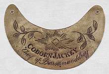
James White was the first European settler in the district and established Burrangong Station in 1826 with a squatting claim of 260 square kilometres (100 sq mi).[5] His story is told in the novel Brothers in Exile. Gold was found in the district in 1860. Until that time the area was called Lambing Flat, a reference to the grazing of sheep that was the main industry until mining. The town was gazetted in 1861. The goldfields produced 15,000 kilograms (470,000 ozt) of gold sent by escort from the fields. Up to 20,000 miners worked the fields including about 2,000 Chinese miners.[5]
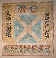
From November 1860 through to June 1861, anti-Chinese miners attacked Chinese gold miners in the area, now known as the infamous Lambing Flat riots. As gold became scarce, European miners began to resent what they saw as the greater success of the more industrious Chinese, and hence many Chinese miners were attacked, robbed and killed. The anti-Chinese rebels rallied in numbers of up to 3,000. Eventually the rioters were controlled, Chinese miners had their claims restored to them, but the New South Wales Parliament passed the Chinese Immigration Bill which restricted the number of Chinese that could be brought into New South Wales on any ship and imposed a tax per head on entry.
In 1889 Young was the first town in Australia to install electricity into the streets and homes of the township; Tamworth NSW had installed electricity to the streets only the previous year.
The former Young Shire was acknowledged as the first Local Government Area to institute a rural school bus system in New South Wales.[5]
Heritage listings
Young has a number of heritage-listed sites, including:
- Blayney-Harden railway: Young railway station[7]
- Lynch Street: City Bank building[8]
- Whiteman Avenue: Blackguard Gully[9]
Climate
Young has a humid subtropical climate (Cfa).[10]
| Climate data for Young Airport | |||||||||||||
|---|---|---|---|---|---|---|---|---|---|---|---|---|---|
| Month | Jan | Feb | Mar | Apr | May | Jun | Jul | Aug | Sep | Oct | Nov | Dec | Year |
| Record high °C (°F) | 42.6 (108.7) |
43.0 (109.4) |
38.6 (101.5) |
32.6 (90.7) |
25.4 (77.7) |
21.9 (71.4) |
19.9 (67.8) |
23.6 (74.5) |
30.8 (87.4) |
34.4 (93.9) |
42.1 (107.8) |
41.1 (106) |
43.0 (109.4) |
| Average high °C (°F) | 31.8 (89.2) |
30.5 (86.9) |
27.2 (81) |
22.7 (72.9) |
17.8 (64) |
13.9 (57) |
13.0 (55.4) |
14.6 (58.3) |
17.9 (64.2) |
22.1 (71.8) |
26.1 (79) |
29.2 (84.6) |
22.2 (72) |
| Average low °C (°F) | 14.7 (58.5) |
14.7 (58.5) |
11.3 (52.3) |
6.6 (43.9) |
3.3 (37.9) |
2.3 (36.1) |
1.0 (33.8) |
1.3 (34.3) |
3.0 (37.4) |
5.3 (41.5) |
9.3 (48.7) |
11.9 (53.4) |
7.0 (44.6) |
| Record low °C (°F) | 1.4 (34.5) |
2.3 (36.1) |
0.4 (32.7) |
−4.1 (24.6) |
−5.8 (21.6) |
−6.1 (21) |
−7.0 (19.4) |
−6.5 (20.3) |
−5.5 (22.1) |
−4.7 (23.5) |
−2.4 (27.7) |
−0.2 (31.6) |
−7.0 (19.4) |
| Average precipitation mm (inches) | 40.7 (1.602) |
50.6 (1.992) |
46.6 (1.835) |
31.7 (1.248) |
40.5 (1.594) |
61.6 (2.425) |
59.7 (2.35) |
51.1 (2.012) |
52.4 (2.063) |
45.6 (1.795) |
64.0 (2.52) |
57.9 (2.28) |
608.8 (23.969) |
| Average precipitation days | 6.9 | 7.3 | 6.8 | 5.7 | 9.8 | 14.7 | 17.5 | 14.8 | 11.3 | 9.1 | 8.5 | 7.2 | 119.6 |
| Average afternoon relative humidity (%) | 31 | 34 | 35 | 40 | 51 | 63 | 63 | 55 | 51 | 44 | 38 | 31 | 45 |
| Source: [11] | |||||||||||||
Demographics
On 2016 census night, 9 August 2016, there were 7,170 people (3,385 males and 3,783 females) counted in Young. There were 367 people (5.1%) (197 males and 172 females) who identified as being of Indigenous origin. The median age of people was 40 years.[1]
The number of people born overseas in the 2016 Census was 1023 (13.9%) compared with 650 (5.8%) in the 2001 Census, 589 (5.3%) in the 1996 Census and 549 (5.1%) in the 1991 Census. Of those born overseas, the three main countries of birth in the 2016 Census were:
- England: 95 (1.3%)
- New Zealand: 47 (0.7%) and;
- Lebanon: 37 (0.5%).
In the 2016 Census, the three most common ancestries identified with were:
- Australian: 3405 people (35.8%)
- English: 2957 people (31.1%) and;
- Irish: 1045 people (11.0%).
English was stated as the only language spoken at home by 6,413 people (89.6%) in the 2016 Census. The three most common languages spoken at home other than English in the 2016 Census were:
- Arabic (including Lebanese): 88 (1.2%)
- Tagalog: 22 (0.3%) and;
- Mandarin: 22 (0.3%).
In the week preceding the 2016 Census, 1894 households (67.8%) had accessed the internet at home. 501 (8.9%) people held a bachelor's degree or above. 212 people were unemployed, representing 7.6% of the labour force. The median weekly individual income for people aged 15 years and over in the 2016 Census was $505. In the 2016 Census, there were 2,324 separate houses (83.2%), 202 semi-detached, row or terrace houses and townhouses (7.2%), 257 flats, units or apartments (9.2%) and 3 other dwellings (0.1%). In the 2016 Census, there were 594 couple families with children (which comprised 34.4% of all families in occupied private dwellings), 675 couple families without children (39.1%), 431 one parent families (24.9%) and 28 other families (1.6%).
The Lambing Flat Chinese Tribute Gardens
Young Shire Council established the Lambing Flat Chinese Tribute Gardens adjacent to the site of Chinamans Dam, an old railway dam approximately 4 kilometres (2.5 mi) south of Young. The gardens are intended to create an ambience similar to the Japanese Gardens at Cowra. Chinamans Dam, with an initial capacity of over 9,100 cubic metres (2×10⁶ imp gal) when it was in railway use, is situated at a hamlet called Pitstone on Sawpit Gully. The dam was built in the 1860s by Dutch brothers, Herman and John Tiedemann, to provide water for the sluicing of their Victoria Hill gold claims. At some time in the 1870s, the brothers sold the area, including the dam, to a Chinese group who worked the site.[12]
The dam was used as a railway facility from 1882 when the NSW Railway Commissioners gave notice of the intention to build the first part of the Blayney-Demondrille railway. To provide water for its steam locomotives, the Commissioners decided to provide a dam and pump water from it to a facility, known as Young Tank, at the 396-kilometre (246 mi) post. It is not known whether the railways enhanced the existing dam or built a new facility.[12]
From 1885 to 1901, locomotives stopped at Young Tank to replenish their water. In 1901, watering facilities were built at Young Station. The supply of water was obtained from Chinamans Dam. The capacity of the dam was enlarged in 1911. The dam was a popular spot for swimming and, whilst officially frowned upon, was tolerated.[12]
Following the connection to the South West Tablelands Water Supply Scheme, which provided water from Burrinjuck Dam, the railways ceased to draw water from Chinamans Dam after 1936. The site was returned to the Crown in 1962 and in the following year, a 15-hectare (36-acre) reserve was established and the Shire Council were appointed as trustees. The dam has since been enlarged.[12]
Education
Young has six schools:
- St Mary's Primary School
- M-E-T School Young Campus now closed replaced by Muslim school
- Young North Primary School
- Young Public School
- Hennessy Catholic College
- Young High School
Sport
The town's rugby league team competed for the Maher Cup.
- Young Yabbies is a rugby union team playing in the Southern Inland Rugby Union competition.
- Young Cherrypickers is a rugby league team playing in the Group 9 competition
- Young Saints is an Australian football team playing in the Central West AFL competition.
- Young Lions is a soccer club fielding teams that play in the Bathurst District Soccer Senior Men's and Senior Women's competition.
Media
Newspapers
- Burrangong Argus 1864-1914 (became the Young Witness)
- Burrangong Chronicle 1873-1902 (became the Young Chronicle)
- Burrangong Courier 1962 (ceased publication)
- The Lambing Flat Miner 1862-1961 (ceased publication)
- Young Chronicle 1902-1947 (incorporated in The Young Witness)
- The Young Witness 1914-
Radio stations
- ABC Classic FM 88.3
- ABC Radio National 89.1/97.1
- ABC Riverina 89.9/96.3
- Roccy FM 93.9 (commercial)
- SBS Radio FM 98.7 (retransmission)
- triple j 90.7
- 2LF AM 1350 (commercial)
- 2YYY (community radio)
Notable people
- Charles Anderson VC, MC (1897-1988), a Member of Parliament
- Peter Cusack, a rugby league footballer
- Libby Gleeson, a children's author
- Ron Lynch, a rugby league footballer and coach
- Nathan Lyon, an Australian cricketer
- Roger McDonald, an author
- Kerry Saxby-Junna, double Commonwealth Games gold medal racewalker
References
- 1 2 Australian Bureau of Statistics (27 June 2017). "Young (Urban Centre)". 2016 Census QuickStats. Retrieved 3 December 2017.

- ↑ Premier Postal History. "Post Office List". Premier Postal Auctions. Archived from the original on 19 August 2008. Retrieved 26 May 2011.
- ↑ "Young". Geographical Names Register (GNR) of NSW. Geographical Names Board of New South Wales. Retrieved 30 July 2013.
- ↑ Reed, A. W. (1973). Place Names of Australia (1984 ed.). Frenches Forest: Reed Books. p. 234.
- 1 2 3 4 "History". visityoung.com. Archived from the original on 8 February 2007. Retrieved 9 February 2007.
- ↑ "New beginning". The Young Witness. Fairfax Media. 12 July 2013. Archived from the original on 25 April 2014.
- ↑ "Young Railway Station and yard group, New South Wales State Heritage Register (NSW SHR) Number H01294". New South Wales State Heritage Register. Office of Environment and Heritage. Retrieved 17 May 2018.
- ↑ "City Bank (former), New South Wales State Heritage Register (NSW SHR) Number H00710". New South Wales State Heritage Register. Office of Environment and Heritage. Retrieved 17 May 2018.
- ↑ "Blackguard Gully, New South Wales State Heritage Register (NSW SHR) Number H01775". New South Wales State Heritage Register. Office of Environment and Heritage. Retrieved 17 May 2018.
- ↑ R.L. Specht; Philip Rundel; W.E. Westman; P.C. Catling; Jonathan Majer; Penelope Greenslade (6 December 2012). Mediterranean-type Ecosystems: A data source book. Springer Science & Business Media. p. 95. ISBN 978-94-009-3099-5.
- ↑ "Climate statistics for Young Airport". Bureau of Meteorology. Commonwealth of Australia. Archived from the original on 18 November 2017. Retrieved 18 November 2017.
- 1 2 3 4 Sharp, Stuart (January 2002). "Chinaman's Dam Young". Australian Railway Historical Society Bulletin: 3–8.
External links
![]()