Harden, New South Wales
| Harden New South Wales | |||||||||
|---|---|---|---|---|---|---|---|---|---|
 | |||||||||
|
Harden | |||||||||
| Coordinates | 34°33′0″S 148°22′0″E / 34.55000°S 148.36667°ECoordinates: 34°33′0″S 148°22′0″E / 34.55000°S 148.36667°E | ||||||||
| Population | 2,030 (2016 census)[1] | ||||||||
| Postcode(s) | 2587 | ||||||||
| Elevation | 431 m (1,414 ft) | ||||||||
| LGA(s) | Hilltops Council | ||||||||
| State electorate(s) | Cootamundra | ||||||||
| Federal Division(s) | Riverina | ||||||||
| |||||||||
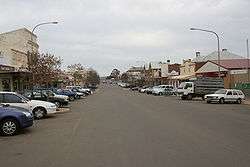
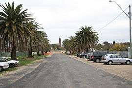
Harden-Murrumburrah is a township and community in Hilltops Region and is located in the South West Slopes of New South Wales in Australia and is adjacent to both the Canberra region of the Australian Capital Territory and the Riverina Region in the southwest area of NSW. The town is a twin town between Harden and Murrumburrah (which is noted as one of the earliest settlements in the southwest of New South Wales).
The town is traversed by the Burley Griffin Way, the major link from and between the Riverina and the Hume Highway near Yass, and ultimately Sydney, Canberra and the coast. Cunningham Creek runs along the edge of the town.
The Olympic Highway traverses the western end of the shire and is the major link through the central west to the Blue Mountains and from there to the Sydney region.
Harden is 3½ hours away by road from Sydney, and 1½ hours from Canberra and Wagga Wagga.
History
Before European settlement the Harden area was inhabited by the Wiradjuri people. Hume and Hovell passed nearby in 1824. In the late 1820s, the 'Murrumburra' was established. Its superintendent, James Kennedy, established an inn on the townsite in the late 1840s. Gold was found in the area in the 1850s.[2]
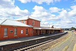
Harden railway station was opened one km east of Murrumburrah on the Main Southern line in 1877 as Murrumburrah, but changed its name to Harden a year after the opening of a new station in Murrumburrah in 1879. Harden has remained as the main station and, as a result, became the main town.[3]
Harden Post Office opened on 1 January 1870.[4] The first Australian Lighthorse was also founded in Harden-Murrumburrah, with the Lighthorse festival occurring annually.
From 1906 until 2016 Harden-Murrumburrah was the seat of its own local council, but was amalgamated in 2016 in Hilltops Council. The town's rugby league team competed for the Maher Cup.
Heritage listings
Harden has a number of heritage-listed sites, including:
- Main Southern railway: Harden railway station[5]
Transport
The Main Southern railway line passes through Harden. It became an important railway town with the line to Blayney branching off a few kilometres beyond Harden at Demondrille. Harden railway station is served by two daily NSW TrainLink XPT services to Melbourne and Sydney in each direction and a weekly Xplorer service to Griffith and Sydney. NSW TrainLink also operates a road coach service between Cootamundra and Canberra.[6] Busabout Wagga Wagga have a depot in the town.[7]
Gallery
 Harden National Australia Bank
 Harden Mechanics Institute
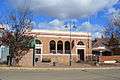 Harden Post office
 Royal Hotel
 Grand Hotel Harden
 Harden Doncaster Hotel
 Harden Carrington Hotel
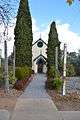 Former Harden Methodist Church
 Harden Catholic Church
 Harden Trinity Centre
 Harden Shire Council Office
Notes
- ↑ Australian Bureau of Statistics (27 June 2017). "2016 Community Profiles: Harden". 2016 Census of Population and Housing.

- ↑ "Harden". Walkabout, John Fairfax. Retrieved 2007-01-25.
- ↑ "Harden Railway Station". www.nswrail.net. Retrieved 2007-01-25.
- ↑ Premier Postal History. "Post Office List". Premier Postal Auctions. Retrieved 26 May 2011.
- ↑ "Harden Railway Station and yard group, New South Wales State Heritage Register (NSW SHR) Number H01165". New South Wales State Heritage Register. Office of Environment and Heritage. Retrieved 18 May 2018.
- ↑ "Southern timetable" (PDF). NSW Trainlink. 26 November 2017.
- ↑ Harden Depot School Bus Services Busabout Wagga Wagga
External links
![]()
| Preceding station | NSW TrainLink | Following station | ||
|---|---|---|---|---|
| NSW TrainLink Southern Griffith Xplorer Melbourne XPT | towards Sydney |