Yelizavetpolsky Uyezd
| Elisabethpol Uyezd (in English) | ||
|---|---|---|
| ||
 | ||
| ||
| Established | 1840 | |
| Abolished | 1929 | |
| Political status | Uyezd | |
| Region | Caucasus | |
| Area | 7,695.7 verst² | |
| Population (1897 census) | ||
| • Total | 162788 | |
| • Density | 21.2 inhab. / verst² | |
| Government | ||

Elisabethpol Uyezd (Russian: Елизаветпольский уезд), also transliterated as Yelizabethpolsky Uyezd, and known as Ganja Uyezd (Azerbaijani: Gəncə qəzası) was one of the uyezds (administrative units) of Elisabethpol Governorate of the Russian Empire and then of Azerbaijan Democratic Republic with its center in Elisabethpol (Ganja) from 1840 until its formal abolition in 1929 by Soviet authorities.[1][2]
Geography
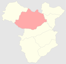
Elisabethpol Governorate consisted of Elisabethpol, Nukhinsky, Shushinsky, Zangezursky, Kazakhsky, Areshsky, Dzhebrailsky, and Dzhevanshirsky Uyezds.[3] Elisabethpol uyezd was located in the northern part of Elisabethpol Governorate, bordering Tiflis Governorate on the north, Kazakhsky Uyezd on the west, Areshsky Uyezd on the east and Javanshir Uyezd on the south. The uyezd center was the city of Elisabethpol. The area of the uyezd was 7695.7 square verst and was divided into two parts: the northeastern lowlands steppes, irrigated by Kura River and its tributaries and southwestern mountainous part, watered by Kura's right bank tributaries. The lowaland part split by Kura and Alazani is not forested, less fertile and was rarely used for farming. The mountainous part of the uyezd stretched up to Lake Goycha. The highest peaks of uyezd, Murovdag, (Azerbaijani: Murovdağ; 11,219 ft), Ginal-dag (Azerbaijani: Ginaldağ; 11,057 ft), Gyamysh (Azerbaijani: Gəmış; 12,263 ft), bordered Javanshir Uyezd of Elisabethpol Governorate and Novobayazet Uyezd of Erivan Governorate. The main rivers flowing down from these mountains into the lowland part of uyezd and discharging into Kura are Kuruk-chay, Ganja-chay, Qoshqara-chay, Shamkhor-chay.[2]
History
After establishment of Russian rule over Azerbaijani khanates in South Caucasus and institution of administrative reforms, the territories of Ganja khanate were incorporated into Tiflis Governorate of the empire. On April 10, 1840 Elisabethpol uyezd was established within Georgian-Imereti Governorate, and on December 14, 1846 it was incorporated into the newly created Tiflis Governorate. In 1868, the uyezd was re-established within the newly founded Elisabethpol Governorate with its capital in Elisabethpol (present day Ganja).[4] After establishment of Azerbaijan Democratic Republic (ADR) in 1918, the uyezd was renamed to Ganja Uyezd, then named back to Yelizavetpolsky Uyezd and then again to Ganja Uyezd on August 10, 1918. On April 22, 1920 a part of Ganja Uyezd was established as Shamkhor Uyezd within ADR. With Bolshevik take over of Azerbaijan and establishment of Soviet rule, the uyezd was abolished on April 8, 1929.[5]
Population
According to census held in 1897, the population of uyezd was 162,788, of which 103,970 were Azerbaijani Turks, 43,040 were Armenians, 10,428 - Russians, 3,086 - Germans, 622 - Georgians, and other minorities.[6] The population was engaged primarily in agricultural farming, gardening, winemaking, corn and rice growing. Wine production in Azerbaijan was mostly seen in the city of Elisabethpol and German-populated town of Helenendorf where 450,000 canisters of wine were produced annually. In 1890, there were 107 factories and plants with a total number of workers at 2,136. There were two copper plants which produced 84% of the copper in Caucasus.[2]
References
- ↑ Chisholm, Hugh (1910). The Encyclopædia britannica: a dictionary of arts, sciences, literature and general information. Volume 9. Leiden, the Netherlands: The Encyclopædia Britannica Company. p. 280. ISBN 978-90-04-17901-1. Retrieved 2011-08-10.
- 1 2 3 "Большой энциклопедический словарь Брокгауза и Ефрона. Елизаветполь" [Brockhaus and Efron Encyclopedia Dictionary. Elisabethpol]. Retrieved 2011-08-10.
- ↑ "Административно-территориальные реформы на Кавказе в середине и во второй половине XIX века" [Administrative-territorial reforms in Caucasus in middle and second half of 19th century]. Retrieved 2011-08-09.
- ↑ "Presidential Library. Coats of Arms and Emblems". Retrieved 2011-08-10.
- ↑ "АДМИНИСТРАТИВНО-ТЕРРИТОРИАЛЬНОЕ ДЕЛЕНИЕ" [Administrative-territorial division] (PDF). Retrieved 2011-08-10.
- ↑ "Первая всеобщая перепись населения Российской Империи 1897 г. Распределение населения по родному языку и уездам Российской Империи кроме губерний Европейской России" [First All Russian Imperial Census of 1897. Population split according to languages spoken; uyezds of Russian empire except for governorates in European part of empire]. Retrieved 2011-08-10.