Wye, Kent
| Wye | |
|---|---|
 Wye parish church | |
 Wye Wye shown within Kent | |
| Area | 24.1 km2 (9.3 sq mi) |
| Population | 2,282 (Civil parish 2011)[1] |
| • Density | 95/km2 (250/sq mi) |
| OS grid reference | TR055466 |
| Civil parish | |
| District | |
| Shire county | |
| Region | |
| Country | England |
| Sovereign state | United Kingdom |
| Post town | Ashford |
| Postcode district | TN25 |
| Dialling code | 01233 |
| Police | Kent |
| Fire | Kent |
| Ambulance | South East Coast |
| EU Parliament | South East England |
| UK Parliament | |
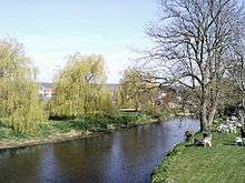
Wye is a mostly hilly village with a conservation area in Kent, England, centred 12 miles (19 km) from Canterbury, and is also the main village in the civil parish of Wye with Hinxhill. The population of the ward was 2,282 in 2011.[1] In March 2013 the village was voted 3rd best place to live in the UK by The Sunday Times.
History
The village's name comes from the Old English "Wēoh" meaning "idol" or "shrine". The place may have used for worship by the pre-Christian Angles.[2]
Wye became an important ancient communications centre because of the ford across the River Great Stour connecting the parts of the ancient trackway across the North Downs at this point. The Romans constructed their road between Canterbury and Hastings using the gap through the North Downs; remains of a Roman camp and villa have been found. By medieval times the town was a market, but in the later 18th century the new turnpike had bypassed the village on the opposite bank of the river; the main A28 road does the same today. Wye railway station was built when the line from Ashford to Margate was opened on 1 December 1846 by the South Eastern Railway.[3]
During the First World War, an aerodrome was established at Wye by the Royal Flying Corps, the station becoming RAF Wye in 1918 and closing the following year. It is now essentially a dormitory village that has lost its local connection to farming, although a few local farmers persist (notably the Long family). Many of the larger estates are industrially farmed. One exception is Ripple Farm which is an organic farm.
Wye Racecourse
Wye Racecourse was here: the first race was run on 29 May 1849, the last 2 May 1974 and closed permanently in June 1975 after being unable to improve the course which the Jockey Club had insisted upon in August 1974. The Long family who owned the course were unable to raise the funds to change the camber on bottom bend and improve the stands and the Jockey Club would not assist and the National Hunt world lost another course. It is described:
Less than one mile (1.6 km) round, and more suited to a greyhound track than a racecourse, Wye could not be entirely classed as the ideal preparation for a tilt at the Champion Hurdle.[4]
Wye College
The Wye Campus of the Imperial College of London (initially as "Wye College") was founded in 1447 as a Latin school and seminary by John Cardinal Kempe, Archbishop of Canterbury and Lord Chancellor.[5] It has been part of London University since 1900. Until 2005 it was an agricultural college: events in 2005 changed that, but the somewhat fraught situation that arose in 2005 regarding the possibility of large scale development. This was the subject of a local campaign to oppose development on the Area of Outstanding Natural Beauty through a local group, Wye Future Group, the campaign was also documented by local author David Hewson in his book Saved, now open-source.[6]. A village website - wyeweb.org - remained open for residents to express their concerns until this year, 2017, having started its life in 2007.
Landmarks
The Anglican church to Saints Gregory and Martin is in the highest category in the national system of listed buildings, Grade I.[7]
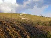
On the Downs east of the village is a crown as a hill figure carved in the chalk by students in 1902 to commemorate the coronation of Edward VII.
Demography
| Wye compared | |||
|---|---|---|---|
| 2001 UK Census | Wye | Ashford district | England |
| Population | 2,405 | 102,661 | 49,138,831 |
| Foreign born | 14.6% | 5.5% | 9.2% |
| White | 94.9% | 97.6% | 90.9% |
| Asian | 1.8% | 0.9% | 4.6% |
| Black | 1.2% | 0.4% | 2.3% |
| Christian | 75.2% | 76.5% | 71.7% |
| Muslim | 1.1% | 0.6% | 3.1% |
| Hindu | 0.4% | 0.3% | 1.1% |
| No religion | 15.3% | 14.6% | 14.6% |
| Unemployed | 1.7% | 2.4% | 3.3% |
| Retired | 16.8% | 13.8% | 13.5% |
At the 2001 UK census, the Wye electoral ward had a population of 2,405. The ethnicity was 94.9% white, 1.5% mixed race, 1.8% Asian, 1.2% black and 0.6% other. The place of birth of residents was 85.4% United Kingdom, 1.1% Republic of Ireland, 4.5% other Western European countries, and 9% elsewhere. Religion was recorded as 75.2% Christian, 0.4% Buddhist, 0.4% Hindu, 0% Sikh and 0.2% Jewish, 1.1% Muslim. 15.3% were recorded as having no religion, 0.2% had an alternative religion and 7.2% did not state their religion.[8]
The economic activity of residents aged 16–74 was 28.2% in full-time employment, 9.3% in part-time employment, 9.6% self-employed, 1.7% unemployed, 7.7% students with jobs, 16.6% students without jobs, 16.8% retired, 5.4% looking after home or family, 2.8% permanently sick or disabled and 2% economically inactive for other reasons. The industry of employment of residents was 12.8% retail, 9.3% manufacturing, 5.3% construction, 14.1% real estate, 9.9% health and social work, 17.7% education, 4.8% transport and communications, 5.5% public administration, 6.2% hotels and restaurants, 2.4% finance, 6.2% agriculture and 5.8% other. Compared with national figures, the ward had a relatively high proportion of workers in agriculture, education, hotels and restaurants. There were a relatively low proportion in manufacturing, construction, retail, finance, transport and communications. Of the ward's residents aged 16–74, 33.5% had a higher education qualification or the equivalent, compared with 19.9% nationwide.[8]
Critical acclaim
In 2006 Wye was featured in BBC TV show The Perfect Village.[9] It was voted as the third best place to live in the UK in an annual broadsheet's review in 2013.[10]
Events
A farmers' market is held in Wye on the first and third Saturday of every month; and an annual summer festival of blues music and real ale, is held each year on the village green.
Sports
Wye has a cricket team with more than one side.
Walks
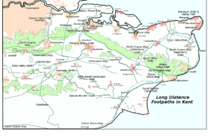
Wye is on the Pilgrims' Way (or North Downs Way and lower Stour Valley Walk/East Kent Downs Walk combined): from Farnham in Surrey to Dover or Canterbury.
In Wye is its crossroads with the upper part of the Stour Valley Walk. Above in the valley are Lenham (along the upper part of the west tributary) and Ashford. Further down the valley are Canterbury and Sandwich Bay where the route ends at the junction with the Saxon Shore Way.
Notable residents
- Aphra Behn, (1640–1689) Restoration dramatist and spy.
- John Kemp, (c1380-1484) English cardinal, Archbishop of Canterbury and Chancellor.
- Catharine Macaulay, (1731–1791) English historian and republican
- Bryan Keith-Lucas, (1912–1996) Political scientist
- Evelyn Mary Dunbar, (1906-1960), artist
See also
References
- 1 2 Key Statistics; Quick Statistics: Population Density United Kingdom Census 2011 Office for National Statistics Retrieved 10 May 2014
- ↑ P. H. Reaney (1969). The Origin of English Place Names. Routledge and Kegan Paul. p. 118. ISBN 0-7100-2010-4.
- ↑ History of Wye
- ↑ History of Wye Racecourse
- ↑ History of the College
- ↑ Saved
- ↑ British listed buildings retrieved 20 July 2013
- 1 2 "Neighbourhood Statistics". Statistics.gov.uk. Retrieved 2008-02-21.
- ↑ Gold, Mary (15 September 2006). "Why pick on Wye?". The Times.
- ↑ "The winners: Our four top spots". The Sunday Times. 17 March 2013.
External links
![]()