Wolf Coal, Kentucky
| Wolf Coal | |
|---|---|
| Unincorporated community | |
 Wolf Coal Location within the state of Kentucky  Wolf Coal Wolf Coal (the US) | |
| Coordinates: 37°23′54″N 83°22′40″W / 37.39833°N 83.37778°WCoordinates: 37°23′54″N 83°22′40″W / 37.39833°N 83.37778°W | |
| Country | United States |
| State | Kentucky |
| County | Breathitt |
| Elevation | 787 ft (240 m) |
| Time zone | UTC-5 (Eastern (EST)) |
| • Summer (DST) | UTC-4 (EDT) |
| ZIP codes | 41393 |
| GNIS feature ID | 516432[1] |
Wolf Coal is an unincorporated community and coal town located in Breathitt County, Kentucky, United States.
References
Municipalities and communities of Breathitt County, Kentucky, United States | ||
|---|---|---|
| City | 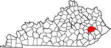 | |
| Unincorporated communities | ||
This article is issued from
Wikipedia.
The text is licensed under Creative Commons - Attribution - Sharealike.
Additional terms may apply for the media files.