Altro, Kentucky
| Altro | |
|---|---|
| Unincorporated community | |
 Altro Location within the state of Kentucky  Altro Altro (the US) | |
| Coordinates: 37°22′51″N 83°22′56″W / 37.38083°N 83.38222°WCoordinates: 37°22′51″N 83°22′56″W / 37.38083°N 83.38222°W | |
| Country | United States |
| State | Kentucky |
| County | Breathitt |
| Elevation | 791 ft (241 m) |
| Time zone | UTC-6 (Eastern Standard Time) |
| • Summer (DST) | UTC-5 (EST) |
| ZIP codes | 41306 |
| GNIS feature ID | 510251[1] |
Altro is an unincorporated community and coal town in Breathitt County, Kentucky, United States. Their post office closed in 1994.[2] Altro is on the North Fork of the Kentucky RIver.[3]
References
- ↑ U.S. Geological Survey Geographic Names Information System: Altro, Kentucky
- ↑ http://webpmt.usps.gov/pmt007.cfm%5Bpermanent+dead+link%5D
- ↑ "ePodunk". www.epodunk.com. Retrieved 2016-01-14.
Municipalities and communities of Breathitt County, Kentucky, United States | ||
|---|---|---|
| City | 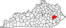 | |
| Unincorporated communities | ||
This article is issued from
Wikipedia.
The text is licensed under Creative Commons - Attribution - Sharealike.
Additional terms may apply for the media files.