Artarmon, New South Wales
| Artarmon Sydney, New South Wales | |||||||||||||||
|---|---|---|---|---|---|---|---|---|---|---|---|---|---|---|---|
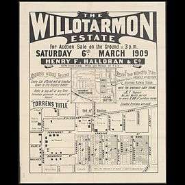 Poster for sale of land in Artarmon, 1909 | |||||||||||||||
| Population | 9,523 (2016 census)[1] | ||||||||||||||
| • Density | 3,810/km2 (9,870/sq mi) | ||||||||||||||
| Established | 1794 | ||||||||||||||
| Postcode(s) | 2064 | ||||||||||||||
| Area | 2.5 km2 (1.0 sq mi) | ||||||||||||||
| Location | 9 km (6 mi) north of Sydney CBD | ||||||||||||||
| LGA(s) | City of Willoughby | ||||||||||||||
| State electorate(s) | Willoughby, Lane Cove | ||||||||||||||
| Federal Division(s) | North Sydney | ||||||||||||||
| |||||||||||||||

Artarmon is a suburb on the lower North Shore of Sydney, in the state of New South Wales, Australia 9 kilometres north-west of the Sydney central business district, in the local government area of the City of Willoughby.[2]
History
In 1794 and 1796, land grants were given to soldiers and emancipists to encourage farming. The most important farm was owned by William Gore (1765–1845) who was the provost-marshal under NSW Governor William Bligh. Gore received a grant of 150 acres (0.61 km2) in 1810 and named it Artarmon after his family estate in Ireland. Gore Hill is named after him.[3]
The Chatswood South Uniting Church, located at the corner of Mowbray Road and the Pacific Highway, was designed by architect and later Mayor of Manly, Thomas Rowe and built in 1871. A sandstone church in the Gothic style, it features a small belfry flanking the eastern front of the building. Immediately to the west is a small cemetery, with graves going back to 1871. The building was extended in 1883 and 1930; it is now listed on the (now defunct) Register of the National Estate.[4] The cemetery is listed by the National Trust and is known as the Pioneer's Memorial Reserve.
Artarmon Post Office opened on 1 December 1909.[5]
Heritage listings
Artarmon has a number of heritage-listed sites, including:
- 559 Pacific Highway: Chatswood Reservoirs No. 1 and No. 2[6]
Demographics
According to the 2016 census of Population, there were 9,523 residents in Artarmon. 46.5% of people were born in Australia. The next most common countries of birth were China 9.8%, India 4.8%, England 3.3%, Hong Kong 2.9% and Japan 2.4%. 50.9% of people only spoke English at home. Other languages spoken at home included Mandarin 11.5%, Cantonese 6.6%, Japanese 3.3%, Korean 2.7% and Nepali 2.4%. The most common responses for religious affiliation were No Religion 36.7%, Catholic 18.1% and Anglican 10.0%.[1]
Commercial area
Artarmon has a mix of residential, commercial and industrial areas. High-rise buildings are located to the west of the railway line and houses to the east. There is also an industrial area south of the Gore Hill Freeway, although the suburb retains a rather leafy feel. A long row of shops is located beside the railway station on Hampden Road and a number of restaurants in Wilkes Avenue on the eastern side of the station. Artarmon Public Library is one of the branch libraries in the City of Willoughby.
Media
The studios of the Special Broadcasting Service (SBS), a public television station, are located in Herbert Street. The Australian Broadcasting Corporation was until recently located on the Pacific Highway, at Gore Hill. Fox Sports is headquartered on Broadcast Way near the Pacific Highway at Gore Hill. The Seven Network and Ten Network broadcast from a high transmission tower, operated by TXA in Hampden Road. The Nine Network has its studios in the adjacent suburb of Willoughby.
The Artarmon Fair is held annually in May.
Transport
Artarmon railway station is on the North Shore, Northern & Western Line of the Sydney Trains network. The Gore Hill Freeway meets the Pacific Highway at Artarmon. Willoughby Council has started a free shuttle bus in between St. Leonards and the Artarmon Industrial Area.
Schools
Artarmon Public School is consistently ranked amongst the best public schools in Sydney. It was ranked 5th in 2010.[7]
Artarmon Public school opened in 1910.[8]
Churches and temples
- Artarmon Community Church
- Artarmon Uniting Church
- Chatswood Spiritualist Church
- Kyegu Tibetan Buddhist Temple and Meditation Centre
- ROCK Sydney Church of God (Indonesian)
- St Basil's Anglican Church
- Artarmon Islamic Mosjid
Notable residents
Photographer Max Dupain had his studio in Artarmon from 1971 till his death in 1992.[9]
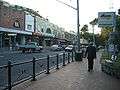 Hampden Road, facing north from the railway station
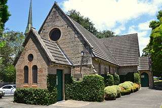 Heritage-listed Chatswood South Uniting Church
Medical_Centre_Mowbray_Road.jpg) Federation cottage converted to medical centre, Mowbray Road
Federation cottage converted to medical centre, Mowbray RoadSt_Basils_Church_Broughton_Road.jpg) St Basil's Anglican Church, Broughton Road
St Basil's Anglican Church, Broughton Road
References
- 1 2 Australian Bureau of Statistics (27 June 2017). "Artarmon (State Suburb)". 2016 Census QuickStats. Retrieved 10 February 2018.

- ↑ Gregory's Sydney Street Directory, Gregory's Publishing Company, 2007
- ↑ The Book of Sydney Suburbs, Frances Pollon, Angus & Robertson Publishers, 1990, ISBN 0-207-14495-8, page 6
- ↑ The Heritage of Australia, Macmillan Company, 1981, p.2/34
- ↑ Premier Postal History. "Post Office List". Premier Postal Auctions. Retrieved 16 June 2012.
- ↑ "Chatswood Reservoirs No. 1 and No. 2, New South Wales State Heritage Register (NSW SHR) Number H01321". New South Wales State Heritage Register. Office of Environment and Heritage. Retrieved 18 May 2018.
- ↑ "NSW Public School Rankings" (PDF).
- ↑ "Our School". Artarmon Public School. Retrieved 29 March 2018.
- ↑ http://australia.gov.au/about-australia/australian-story/max-dupain
External links
| Wikimedia Commons has media related to Artarmon, New South Wales. |
- Artarmon - community profile
- Artarmon Progress Association
- Artarmon Public School
- Rachel Fallowfield (2008). "Artarmon". Dictionary of Sydney. Retrieved 24 September 2015. [CC-By-SA]
Coordinates: 33°48′32″S 151°10′59″E / 33.80894°S 151.18292°E