North Willoughby, New South Wales
| North Willoughby Sydney, New South Wales | |||||||||||||||
|---|---|---|---|---|---|---|---|---|---|---|---|---|---|---|---|
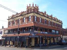 Willoughby Hotel, Penshurst Street | |||||||||||||||
| Population | 4,172 (2016 census)[1] | ||||||||||||||
| Postcode(s) | 2068 | ||||||||||||||
| Location | 9 km (6 mi) north of Sydney CBD | ||||||||||||||
| LGA(s) | City of Willoughby | ||||||||||||||
| State electorate(s) | Willoughby | ||||||||||||||
| Federal Division(s) | North Sydney | ||||||||||||||
| |||||||||||||||
North Willoughby is a suburb on the lower North Shore of Sydney, in the state of New South Wales, Australia 9 kilometres north of the Sydney central business district, in the local government area of the City of Willoughby. Willoughby and East Willoughby are separate suburbs.
History
North Willoughby Post Office opened on 1 September 1871 and closed in 1891.[2]
Commercial areas
A small group of shops and cafes is located on Penshurst Street and includes the Willoughby Hotel, a local landmark building. The hotel was established in 1899 and was described as "one of the finest buildings in the northern suburbs".[3] It was almost demolished in 1940, but survived and had a major restoration in 1988.
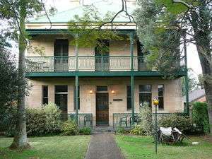
Another landmark is Rosewall, a two-storey home in the Georgian style, made of sandstone. It was built in the 1880s for the Forsyth family, who ran tanneries in the area. The nearby Rosewall and Forsyth Streets are named after the house and family.
The High Street Markets in High Street include various local shops including Harris Farm Markets[4], cafes, takeaway food and restaurants.
Churches
St John's Anglican Church
St Thomas' Church [5]
References
- ↑ Australian Bureau of Statistics (27 June 2017). "North Willoughby (State Suburb)". 2016 Census QuickStats. Retrieved 15 March 2018.

- ↑ Premier Postal History. "Post Office List". Premier Postal Auctions. Retrieved 16 June 2012.
- ↑ Willoughby Hotel site
- ↑ https://www.harrisfarm.com.au/pages/willoughby
- ↑ https://www.google.com.au/maps/uv?hl=en&pb=!1s0x6b12a9304fbf1c41:0x571e0d820ad6b1f4!2m22!2m2!1i80!2i80!3m1!2i20!16m16!1b1!2m2!1m1!1e1!2m2!1m1!1e3!2m2!1m1!1e5!2m2!1m1!1e4!2m2!1m1!1e6!3m1!7e115!4shttps://lh5.googleusercontent.com/p/AF1QipMHjs_8u0D3nI4Q6tnoK0t7s3kcUB4c3xZxwzUw%3Dw212-h160-k-no!5sst+thomas+church+willoughby+-+Google+Search&imagekey=!1e10!2sAF1QipMHjs_8u0D3nI4Q6tnoK0t7s3kcUB4c3xZxwzUw&sa=X&ved=0ahUKEwj8j--HoJjcAhVCHJQKHW5vDJ0QoioIcDAK
Coordinates: 33°47′42″S 151°12′14″E / 33.795°S 151.204°E
| Wikimedia Commons has media related to North Willoughby, New South Wales. |