Wiesenttal
| Wiesenttal | ||
|---|---|---|
| ||
 Wiesenttal Location of Wiesenttal within Forchheim district 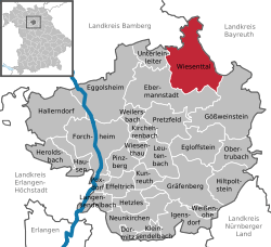 | ||
| Coordinates: 49°47′N 11°16′E / 49.783°N 11.267°ECoordinates: 49°47′N 11°16′E / 49.783°N 11.267°E | ||
| Country | Germany | |
| State | Bavaria | |
| Admin. region | Oberfranken | |
| District | Forchheim | |
| Government | ||
| • Mayor | Helmut Taut | |
| Area | ||
| • Total | 45.90 km2 (17.72 sq mi) | |
| Elevation | 310 m (1,020 ft) | |
| Population (2017-12-31)[1] | ||
| • Total | 2,512 | |
| • Density | 55/km2 (140/sq mi) | |
| Time zone | CET/CEST (UTC+1/+2) | |
| Postal codes | 91346 | |
| Dialling codes | 09196 | |
| Vehicle registration | FO | |
| Website | www.wiesenttal.de | |

Wiesenttal is a municipality in the district of Forchheim in Bavaria in Germany.
Municipal subdivisions
Wiesenttal is divided into 21 parishes:[2]
- Albertshof
- Birkenreuth
- Draisendorf
- Engelhardsberg
- Gößmannsberg
- Haag
- Kuchenmühle
- Muggendorf
- Neudorf
- Niederfellendorf
- Oberfellendorf
- Rauhenberg
- Schottersmühle
- Störnhof
- Streitberg
- Trainmeusel
- Voigendorf
- Wartleiten
- Wohlmannsgesees
- Wöhr
- Wüstenstein
References
This article is issued from
Wikipedia.
The text is licensed under Creative Commons - Attribution - Sharealike.
Additional terms may apply for the media files.