Gößweinstein
| Gößweinstein | ||
|---|---|---|
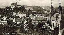
 View of the town | ||
| ||
 Gößweinstein Location of Gößweinstein within Forchheim district 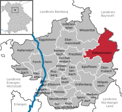 | ||
| Coordinates: 49°46′N 11°19′E / 49.767°N 11.317°ECoordinates: 49°46′N 11°19′E / 49.767°N 11.317°E | ||
| Country | Germany | |
| State | Bavaria | |
| Admin. region | Oberfranken | |
| District | Forchheim | |
| Government | ||
| • Mayor | Georg Lang (CSU) | |
| Area | ||
| • Total | 57.70 km2 (22.28 sq mi) | |
| Elevation | 312 m (1,024 ft) | |
| Population (2017-12-31)[1] | ||
| • Total | 4,034 | |
| • Density | 70/km2 (180/sq mi) | |
| Time zone | CET/CEST (UTC+1/+2) | |
| Postal codes | 91327 | |
| Dialling codes | 09242 | |
| Vehicle registration | FO | |
| Website | www.goessweinstein.de | |

Gößweinstein is a municipality in the district of Forchheim in Bavaria in Germany. It lies within the region known as Franconian Switzerland.
Districts
|
|
|
History
The first record of Goswinesteyn Castle is from 1076. Prior to 1102 the Hochstift Bamberg became the owner of the castle. The prince-bishop of Bamberg Friedrich Carl von Schönborn (ruled from 1729 until 1746) elevated Gößweinstein's status to a Market. During the Secularization in 1803, the area of the Hochstift Bamberg was transferred to Bavaria. During the Bavarian territorial reforms in 1978, the formerly independent communities of Morschreuth, Wichsenstein, Behringersmühle, Kleingesee, Leutzdorf, Stadelhofen, Unterailsfeld and part of the community Tüchersfeld were integrated into Gößweinstein.
Culture and sights
Museums
- Franconian Toy Museum Gößweinstein
- Natural history and geological Collection in the Haus des Gastes
- Steam locomotive train (Dampfbahn Fränkische Schweiz)
Buildings
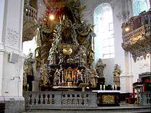
- Pilgrimage church of the Holy Trinity, 1730–1739 built during the reign of Fürstbischof Friedrich Carl von Schönborn according to plans by Balthasar Neumann, who also supervised the construction. Franciscan padre Prof. Dr. Luchesius Spätling applied for the denomination as Basilica minor. The church was elevated to the papal Basilica minor in 1948 by Pope Pius XII.
- Gößweinstein Castle
- Viktor-von-Scheffel-memorial On both sides, there are the lines of the poem "Ausfahrt" (Exit):
- Ich fahr’ in die Welt!
- Mein Hutschmuck die Rose, mein Lager im Moose,
- Der Himmel mein Zelt.
- Mag lauern und trauern, wer will, hinter Mauern –
- Ich fahr’ in die Welt!
Lookout points
- Gernerfels
- Kreuzberg with high cross
- Martinswand (Bellevue)
- Pavillon Wagnershöhe
- Ludwigshöhe (Theaterhöhle)
- Bärenstein (529 m NN)
- Fischersruh
- Nuremberg Chapel
- Aussichtsfelsen Wichsenstein (585 m NN)
Politics
The municipal council in Gößweinstein has 16 members plus an extraofficial mayor.
| CSU | SPD | FW | Jugend und Frauen | Bürgergemeinschaft | Bürger vertreten Bürger | Total | |
|---|---|---|---|---|---|---|---|
| 2002 | 5 | 3 | 3 | 2 | 2 | 1 | 16 seats |
(local elections on March 3, 2002)
References
- ↑ "Fortschreibung des Bevölkerungsstandes". Bayerisches Landesamt für Statistik und Datenverarbeitung (in German). September 2018.
External links
- Official homepage (German)
- Franconian Toy Museum