Gräfenberg, Bavaria
| Gräfenberg, Bavaria | ||
|---|---|---|
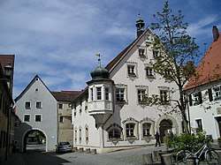 Old town hall | ||
| ||
 Gräfenberg, Bavaria Location of Gräfenberg, Bavaria within Forchheim district  | ||
| Coordinates: 49°38′N 11°15′E / 49.633°N 11.250°ECoordinates: 49°38′N 11°15′E / 49.633°N 11.250°E | ||
| Country | Germany | |
| State | Bavaria | |
| Admin. region | Oberfranken | |
| District | Forchheim | |
| Municipal assoc. | Gräfenberg, Bavaria | |
| Government | ||
| • Mayor | Hans-Jürgen Nekolla (SPD) | |
| Area | ||
| • Total | 37.88 km2 (14.63 sq mi) | |
| Elevation | 433 m (1,421 ft) | |
| Population (2017-12-31)[1] | ||
| • Total | 4,026 | |
| • Density | 110/km2 (280/sq mi) | |
| Time zone | CET/CEST (UTC+1/+2) | |
| Postal codes | 91322 | |
| Dialling codes | 09192 | |
| Vehicle registration | FO | |
| Website |
www | |

Gräfenberg is a Franconian town in the district of Forchheim, in Bavaria, Germany. It is situated 16km southeast of Forchheim and 25km northeast of Nuremberg.
Location
Gräfenberg is located in the southern part of Little Switzerland. The town is characterised by a great range of elevation (from 400 to 550 metres). A brook, the Kalkach, flows through the town with a steep drop.
Gräfenberg is divided into 16 districts:
- The town Gräfenberg
- Lilling
- Hohenschwärz
- Kasberg
- Walkersbrunn
- Dörnhof
- Thuisbrunn
- Höfles
- Sollenberg
- Rangen
- Haidhof
- Schlichenreuth
- Guttenburg
- Neusles
- Lillinger Höhe
- Gräfenberger Hüll
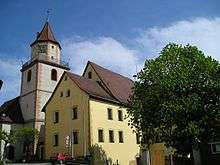
Pictures
Religion
Gräfenberg is a majority Protestant town; even so, some districts (Lilling, Sollenberg) are majority Catholic.
History
Gräfenberg was first mentioned in the year 1172. From 1333 onward the patrician family Haller reigned in Gräfenberg. In 1371 King Karl IV granted the market municipal law. In 1567 a fire destroyed the parts of town located back of the walls. In 1778 a flood wave, resulting from heavy rainfalls, killed six people. With the Reichsdeputationshauptschluss in 1803 the town became part of Bavaria. In the Austro-Prussian War between the German Confederation (which included Bavaria), and Prussia and her allies, the town was the headquarters of the Prussian army at the time that the ceasefire between Bavaria and Prussia was declared in 1866.
In the 1960s and 1970s the other districts of Gräfenberg became part of the borough: for example Lilling (first mentioned 1205) and Thuisbrunn (first mentioned 1007).
Local council
Local elections were held on March 16, 2014 with the following results:
- Free voters Bavaria 5 seats
- Social Democratic Party of Germany 4 seats
- Christian Social Union in Bavaria 4 seats
- Gräfenberg citizens (GBL) 2 seats
- Alliance '90/The Greens 1 seat
Mayors
Hans-Jürgen Nekolla (SPD) is the mayor since May 1, 2014. He won the election on March 30, 2014 against Hans Derbfuß (CSU) with nearly 62 % of the vote. His predecessor was since 1996 Werner Wolf (Free Voters Bavaria).
References
- ↑ "Fortschreibung des Bevölkerungsstandes". Bayerisches Landesamt für Statistik und Datenverarbeitung (in German). September 2018.
External links
