Langensendelbach
| Langensendelbach | ||
|---|---|---|
 | ||
| ||
 Langensendelbach Location of Langensendelbach within Forchheim district 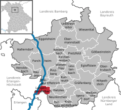 | ||
| Coordinates: 49°39′N 11°04′E / 49.650°N 11.067°ECoordinates: 49°39′N 11°04′E / 49.650°N 11.067°E | ||
| Country | Germany | |
| State | Bavaria | |
| Admin. region | Oberfranken | |
| District | Forchheim | |
| Government | ||
| • Mayor | Wolfgang Fees (SPD) | |
| Area | ||
| • Total | 9.59 km2 (3.70 sq mi) | |
| Elevation | 296 m (971 ft) | |
| Population (2017-12-31)[1] | ||
| • Total | 3,121 | |
| • Density | 330/km2 (840/sq mi) | |
| Time zone | CET/CEST (UTC+1/+2) | |
| Postal codes | 91094 | |
| Dialling codes | 09133 | |
| Vehicle registration | FO | |
| Website | www.langensendelbach.de | |

Langensendelbach is a municipality in the district of Forchheim in Bavaria in Germany. There live about 3500 inhabitants the village Bräuningshof is a part of Langensendelbach..
History: Langensendelbach was first named on the July 13th in the year 1062. After this Langensendelbach was a part of the bistum Bamberg. In the year 1400 St. Peter and Paul chapel was built, in the 14/15th century a small gothic church was built. In the year 1896 the priest named Wölfel found an old German bodygrave from the fifth century. In the World War I 22 men from Langensendelbach died. In World War II 88 men had to fight, nineteen of them died in the war or in prison. A few days before the War ended, SS troops were in the village, the US Army attacked them and three children and one man died.
References
- ↑ "Fortschreibung des Bevölkerungsstandes". Bayerisches Landesamt für Statistik und Datenverarbeitung (in German). September 2018.