Wiñay Wayna
 View of Wiñay Wayna | |
 Shown within Peru | |
| Alternative name | Huiñay Huayna |
|---|---|
| Location | Cusco Region, Peru |
| Region | Andes |
| Coordinates | 13°11′34″S 72°32′11″W / 13.19278°S 72.53639°WCoordinates: 13°11′34″S 72°32′11″W / 13.19278°S 72.53639°W |
| Type | Settlement |
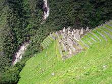
Wiñay Wayna (2650 m) (Quechua for "forever young", hispanicized spelling Huiñay Huayna) is an Inca ruin along the Inca Trail to Machu Picchu. It is built into a steep hillside overlooking the Urubamba River. The site consists of upper and lower house complexes connected by a staircase and fountain structures. Above and below the houses the people built areas of agricultural terraces or andenes, which are still visible.
A camp site for hikers with the same name is located in the vicinity and is usually used as the last overnight camping site for hikers undertaking the classical Inca Trail.[1]
Gallery
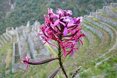 Epidendrum secundum, commonly called "Wiñay Wayna", in front of the ruins
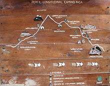 Location of Wiñay Wayna as shown on a sign near Willkaraqay
Reference
| Wikimedia Commons has media related to Wiñay Wayna. |
This article is issued from
Wikipedia.
The text is licensed under Creative Commons - Attribution - Sharealike.
Additional terms may apply for the media files.