White River (Green River tributary)
| White River | |
| Rio Blanco | |
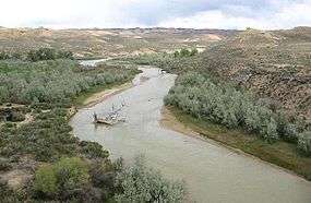 The White River in Uintah County, Utah | |
| Country | United States |
|---|---|
| States | Colorado, Utah |
| Part of | Colorado River |
| Tributaries | |
| - left | South Fork White River |
| - right | North Fork White River |
| Cities | Meeker, Colorado, Rangely, Colorado, Bonanza, Utah, Ouray, Utah |
| Source | Confluence of North Fork and South Fork |
| - location | Rio Blanco County, Colorado |
| - elevation | 6,932 ft (2,113 m) |
| - coordinates | 39°58′22″N 107°38′18″W / 39.97278°N 107.63833°W [1] |
| Mouth | Green River |
| - location | Uintah County, Utah |
| - elevation | 4,646 ft (1,416 m) |
| - coordinates | 40°03′44″N 109°40′45″W / 40.06222°N 109.67917°WCoordinates: 40°03′44″N 109°40′45″W / 40.06222°N 109.67917°W [1] |
| Length | 195 mi (314 km) |
| Basin | 5,120 sq mi (13,261 km2) |
| Discharge | for Watson, Utah |
| - average | 689 cu ft/s (20 m3/s) [2] |
| - max | 8,160 cu ft/s (231 m3/s) |
| - min | 13 cu ft/s (0 m3/s) |
_basin_map.png) Map of the White River watershed | |
| Wikimedia Commons: White River (Green River) | |
White River is a river, approximately 195 miles (314 km) long, in the U.S. states of Colorado and Utah and is a tributary of the Green River (which flows into the Colorado River).[3][1]
Description
The river rises in two forks in northwestern Colorado in northeastern Garfield County in the Flat Tops Wilderness Area in the White River National Forest. The North Fork rises in Wall Lake, and flows northwest, then southwest. The South Fork rises ten miles south of the north, flows southwest, then northwest, past Spring Cave. The two forks join near Buford in eastern Rio Blanco County, forming the White. It flows west, then northwest, past Meeker (site of the White River Museum), and across the broad valley between the Danforth Hills on the north and the Roan Plateau on the south. Downstream from Meeker, it is joined by Piceance Creek and Yellow Creek. In western Rio Blanco County, it turns southwest, flows past Rangely, where it is joined by Douglas Creek, and into Uintah County, Utah, where it joins the Green 2 miles (3.2 km) south of Ouray.
The White River is navigable by small boats throughout most of its length. But in low water years the water level may be too low for navigation for a period of several months. Flows vary from 400 cu ft/s (11 m3/s) in late summers of dry years to well over 3,000 cu ft/s (85 m3/s) in spring.
Climate
According to the Köppen climate classification system, White River has a semi-arid climate, abbreviated "BSk" on climate maps.[4]
See also
References
- 1 2 3 U.S. Geological Survey Geographic Names Information System: White River
- ↑ "USGS Gage #09306500 on the White River near Watson, Utah" (PDF). National Water Information System: 1923–present. U.S. Geological Survey. 2009. Retrieved 2011-01-16.
- ↑ The National Map (Map). United States Geological Survey. § National Hydrography Dataset high-resolution flowline data. Retrieved 18 Mar 2011.
- ↑ "Climate Summary for White River". weatherbase.com. Retrieved 6 Jan 2017.
External links
![]()
Colorado River system | |||||||||
|---|---|---|---|---|---|---|---|---|---|
| Jurisdictions |
|     | |||||||
| Canyons |
| ||||||||
| Natural features |
| ||||||||
| Tributaries | |||||||||
| Engineering |
| ||||||||
| Designated areas | |||||||||
| Related topics | |||||||||
| Authority control |
|---|