Whig Lane, New Jersey
| Whig Lane, New Jersey | |
|---|---|
| Unincorporated community | |
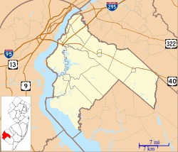 Whig Lane, New Jersey Location within Upper Pittsgrove Township. Inset: Location of Salem County in the state of New Jersey.  Whig Lane, New Jersey Whig Lane, New Jersey (New Jersey)  Whig Lane, New Jersey Whig Lane, New Jersey (the US) | |
| Coordinates: 39°38′22″N 75°13′44″W / 39.63944°N 75.22889°WCoordinates: 39°38′22″N 75°13′44″W / 39.63944°N 75.22889°W | |
| Country |
|
| State |
|
| County | Salem |
| Township | Upper Pittsgrove |
| Elevation | 44 m (144 ft) |
| Time zone | UTC-5 (Eastern (EST)) |
| • Summer (DST) | UTC-4 (EDT) |
| GNIS feature ID | 881769[1] |
Whig Lane is an unincorporated community located within Upper Pittsgrove Township in Salem County, New Jersey, United States.[1][2] It is located approximately 5 mi (8.0 km) east of Woodstown.
The settlement is named for an altercation which occurred there in 1769 between Tories and Whigs.[3] Around that time—prior to the American Revolution—one part of the settlement was also called "Tory Lane".[4]
Whig Lane had a post office in 1897.[1]
References
- 1 2 3 U.S. Geological Survey Geographic Names Information System: Whig Lane
- ↑ Locality Search, State of New Jersey. Accessed January 15, 2015.
- ↑ Elwell, Bonny Beth (2013). Upper Pittsgrove, Elmer, and Pittsgrove. Arcadia. p. 8.
- ↑ New Jersey, a Guide to Its Present and Past. Viking. 1939. p. 654.

This article is issued from
Wikipedia.
The text is licensed under Creative Commons - Attribution - Sharealike.
Additional terms may apply for the media files.