Pointers, New Jersey
| Pointers, New Jersey | |
|---|---|
| Unincorporated community | |
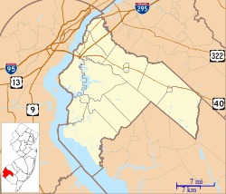 Pointers, New Jersey Pointers's location in Salem County (Inset: Salem County in New Jersey)  Pointers, New Jersey Pointers, New Jersey (New Jersey)  Pointers, New Jersey Pointers, New Jersey (the US) | |
| Coordinates: 39°35′38″N 75°26′43″W / 39.59389°N 75.44528°WCoordinates: 39°35′38″N 75°26′43″W / 39.59389°N 75.44528°W | |
| Country | United States |
| State |
|
| County | Salem |
| Township | Mannington |
| Elevation[1] | 23 ft (7 m) |
| Time zone | UTC-5 (Eastern (EST)) |
| • Summer (DST) | UTC-4 (EDT) |
| GNIS feature ID | 879399[1] |
Pointers is an unincorporated community within Mannington Township in Salem County, New Jersey, United States.[1][2]
The settlement was named "Pointers" because it was located at the intersection of three old roads—Salem Woodstown Road (Route 45), Pointers Auburn Road (County Route 540), and Pointers Sharptown Road (County Route 620)—which "pointed" toward Salem.[3]
The Memorial Hospital of Salem County is located in Pointers, and the "Pointers intersection" was identified in Mannington Township's 2010 Master Plan as one of two commercial districts to be developed.[4]
References
- 1 2 3 U.S. Geological Survey Geographic Names Information System: Pointers
- ↑ "Local Names". State of New Jersey. Retrieved January 2015. Check date values in:
|access-date=(help) - ↑ New Jersey, a Guide to Its Present and Past. Viking. 1939. p. 631. ISBN 9781603540292.
- ↑ Caton, Philip B.; Specca, Lisa Y. (2010). "Comprehensive Farmland Preservation Plan" (PDF). Mannington Township.

This article is issued from
Wikipedia.
The text is licensed under Creative Commons - Attribution - Sharealike.
Additional terms may apply for the media files.