Westmount, Edmonton
| Westmount | |
|---|---|
| Neighbourhood | |
|
Westmount Location of Westmount in Edmonton | |
| Coordinates: 53°33′14″N 113°32′13″W / 53.554°N 113.537°W | |
| Country |
|
| Province |
|
| City | Edmonton |
| Quadrant[1] | NW |
| Ward[1] | 6 |
| Sector[2] | Mature area |
| Government[3] | |
| • Administrative body | Edmonton City Council |
| • Councillor | Scott McKeen |
| Area[4] | |
| • Total | 1.86 km2 (0.72 sq mi) |
| Elevation | 669 m (2,195 ft) |
| Population (2012)[5] | |
| • Total | 5,900 |
| • Density | 3,172/km2 (8,220/sq mi) |
| • Change (2009–12) |
|
| • Dwellings | 3,437 |
Westmount is an established central-west residential neighbourhood in Edmonton, Alberta, Canada. It is geographically close to the downtown core.
The neighbourhood is bounded by 111 Avenue to the north, Groat Road to the west, the Groat Ravine to the southwest, and the North Saskatchewan River valley to the south. Its eastern boundary comprises 124 Street south of Stony Plain Road, and 121 Street north of Stony Plain Road. The southern portion of the neighbourhood is also known as Groat Estates.
The community is represented by the Westmount Community League, established in 1951, which maintains a community hall and outdoor rink located at 127 Street and 109 Avenue.[6][7]
History
The neighbourhood was developed originally in the 1910s as a professional neighbourhood catering to young people. Prior to the end of World War II, one in four (25.6%) of the current residences were constructed. Another quarter of the current residences (23.6%) were constructed between the end of World War II and 1960. One in three residences (35.8%) were constructed between 1961 and 1980. A small portion were constructed after 1980.[8] Many houses in the neighbourhood have been renovated, and some are being replaced with newer and larger houses.
Demographics
In the City of Edmonton's 2012 municipal census, Westmount had a population of 5,900 living in 3,437 dwellings,[5] a -0.8% change from its 2009 population of 5,946.[9] With a land area of 1.86 km2 (0.72 sq mi),[4] it had a population density of 3,172 people/km2 in 2012.[5][4]
Residential development
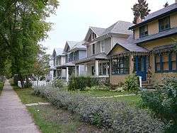

The large majority of the Westmount area is occupied by single family detached houses. This includes a large number of historic homes, often in the Craftsman or Four Square styles, in the Westmount Architectural Heritage Area (WAHA) and the Groat Estates area. The WAHA is bound by 107 St in the south, 127 St in the west, 124 St in the east, and 111 Ave in the north.[10] The Groat Estates are a peninsular shaped area in the southwest portion of Westmount, bound by 107 St in the north, 124 St in the east, the meandering Groat Road Ravine in the west and southwest and the North Saskatchewan River Valley in the south.[11]
124 Street, a major shopping destination, runs North-South through the east side of Westmount, and includes a number of mixed-use developments, condominiums and apartments. Thus, in terms of residential units, the most common type of residence, according to the 2005 municipal census, is a mixture of rented apartments and apartment style condominiums (54%). Single-family dwellings are the next most common (42%). Duplexes[12] account for another 3% of residences, and other types or residence account for the remaining 1%.
The trend is increasing home ownership over time; in 1986, 41% of private dwellings were owned by the occupant, and by 2001 52% were owned by the occupant.[13] Most recently, 54% are owner-occupied, with the remaining 46% being rented.[14]
| Distribution of Types Of Residences - 2005 Census[13] | |||
| Owned[15] | Rented[16] | Total | |
|---|---|---|---|
| Apartment With Five or More Stories | 10% | 8% | 9% |
| Apartment With Fewer Than Five Stories | 21% | 72% | 45% |
| Duplexes | 3% | 4% | 3% |
| Single Family Dwellings | 65% | 15% | 42% |
| Other | 1% | 1% | 1% |
| Total | 100% | 100% | 100% |
People
Over 60% of Westmount adult residents have attended college or university. In terms of highest educational attainment, the largest proportion of residents have obtained a University bacholor's degree or higher, and this is an increasing trend (16.4% in 1986, 21.4% in 1996, 26.5% in 2001).[13]
Average residential income is also on the rise, from $40,001 in 1996 to $52,801 in 2001.[13]
According to the 2005 municipal census, 22.8% of residents had moved in the previous year, 27.4% had moved in the previous one to three years, and 48.6% had lived in the neighbourhood for more than three years.[17]
Schools
The Westmount area is served by a number of pre-schools and schools. Discovery Time Preschool,[18] run as a parent co-operative, operates educational programs for children aged three to five. Westglen Elementary School,[19] on the same block, is operated by the Edmonton Public School System. Westglen includes an International Baccalaureate Middle Years Program, and has a strong environmental commitment, in 2008 being named an Earth III school - "the first school in Alberta and the third in Canada to achieve this status"[19] There are after-school care and childcare centres on the same block.
There are additional schools in the surrounding neighbourhoods, including Westmount Junior High School in Inglewood, Westminster Junior High School in Glenora, and Ross Sheppard High School in Woodcroft. The University of Alberta is just across the river via Groat Road.
NorQuest College maintains a campus in the neighbourhood.
St. Mark Junior High School is also in the area, 500 metres north of Westmount Mall.
Amenities and shopping
Nearby amenities include the Royal Alberta Museum in Glenora, Coronation Park and the Telus World of Science in Woodcroft.
There are several shopping areas in the neighbourhood, including art/retail/commercial districts along 124 Street, and two small upscale shopping centres on 102 Avenue. In addition, Westmount Centre, a major shopping mall, is located just to the north west of the neighbourhood in Woodcroft.
Groat Road also provides access to other destinations on the south side including Whyte Avenue and Old Strathcona.
Parks, green spaces and recreation
Westmount Park occupies three blocks in the heart of Westmount. It includes an outdoor hockey rink, baseball diamonds, soccer fields, a fitness centre, a water-spray park, several playgrounds and the schools noted above.
Westmount also contains several smaller parks with a mix of green space and playgrounds.
A cycling route runs along 127 Street, and a completely separate pedestrial/cycling trail runs along the eastern edge of the neighbourhood, at 121 Street.
Westmount Transit Centre
Westmount Transit Centre | |
|---|---|
| Platforms | 11 bus bays[20] |
| Construction | |
| Parking | No |
| Bicycle facilities | Yes |
| Disabled access | Yes |
| Other information | |
| Website | Westmount Transit Centre |
The Westmount Transit Centre is located between Ross Sheppard High School and Westmount Centre along 135 street. This transit centre has a large shelter, a pay phone and vending machines but does not have public washrooms, park & ride, or a drop off area.[21] The transit centre is served by Edmonton Transit System (ETS) and St. Albert Transit (StAT).
The following bus routes serve the transit centre:[22][23]
| Destination | Routes | |
|---|---|---|
| Acheson | 561 | ETS |
| Belvedere Transit Centre | 125 | ETS |
| Calder | 128 | ETS |
| Castle Downs Transit Centre | 128 | ETS |
| Coliseum Transit Centre | 5, 125 | ETS |
| Downtown | 5 | ETS |
| Eaux Claires Transit Centre | 150 | ETS |
| Jasper Gates | 305 | ETS |
| Jasper Place Transit Centre | 121, 123, 124, 125, 150 | ETS |
| Kingsway/Royal Alex Transit Centre | 125 | ETS |
| Mistatim Industrial | 121, 124 | ETS |
| NAIT | 561 | ETS |
| Northgate Transit Centre | 115, 121, 124, 150 | ETS |
| North-West Industrial | 126, 129 | ETS |
| Stadium Transit Centre | 125 | ETS |
| St. Albert Centre Exchange | 203 | StAT |
| St. Albert Village Transit Station | 203 | StAT |
| University Transit Centre | 128 | ETS |
| West Edmonton Mall Transit Centre | 115, 122, 126, 129, 150 | ETS |
| White Industrial | 129 | ETS |
School special routes that arrive/depart from Westmount Transit Centre include routes: 606, 607, 609, 610, 612, 635, 731, 757, 802, 819, 837, 840, 859, 913, 914 and 916.[24]
Surrounding neighbourhoods
Places adjacent to Westmount, Edmonton | ||||||||||
|---|---|---|---|---|---|---|---|---|---|---|
| ||||||||||
See also
References
- 1 2 "City of Edmonton Wards & Standard Neighbourhoods" (PDF). City of Edmonton. Retrieved February 13, 2013.
- ↑ "Edmonton Developing and Planned Neighbourhoods, 2011" (PDF). City of Edmonton. Retrieved February 13, 2013.
- ↑ "City Councillors". City of Edmonton. Retrieved February 13, 2013.
- 1 2 3 "Neighbourhoods (data plus kml file)". City of Edmonton. Retrieved February 22, 2013.
- 1 2 3 "Municipal Census Results – Edmonton 2012 Census". City of Edmonton. Retrieved February 22, 2013.
- ↑ "Westmount Community League". Westmount Community League. Retrieved October 14, 2017.
- ↑ Kuban, Ron (2005). Edmonton's Urban Villages: The Community League Movement. University of Alberta Press. ISBN 9781459303249.
- ↑ http://censusdocs.edmonton.ca/DD23/FEDERAL%202001/Neighbourhood/WESTMOUNT.pdf
- ↑ "2009 Municipal Census Results". City of Edmonton. Retrieved February 22, 2013.
- ↑ "Westmount Historic Designation, zoning bylaw". City of Edmonton. Retrieved 10 March 2015.
- ↑ "Groat Estate Implementation Plan Consolidation" (PDF). City of Edmonton. 1 October 2012. Retrieved 16 August 2016.
- ↑ Duplexes include triplexes and quadruplexes.
- 1 2 3 4 http://censusdocs.edmonton.ca/DD34/MultiSource/Neighbourhood/WESTMOUNT.pdf
- ↑ http://censusdocs.edmonton.ca/C05002/MUNICIPAL%202005/Neighbourhood/WESTMOUNT.pdf
- ↑ Residence is owner occupied. Where an apartment is owner occupied, it is likely a condominium.
- ↑ Residence is occupied by renters. Where an apartment is rented, it is likely in a rental apartment building, though it could be a condominium the owner has rented to a tenant.
- ↑ http://censusdocs.edmonton.ca/C05022B/MUNICIPAL%202005/Neighbourhood/WESTMOUNT.pdf
- ↑ http://www.discoverytime.ca/preschool/
- 1 2 "Westglen- Westglen School". westglen.epsb.ca. Retrieved 17 April 2018.
- ↑ "Westmount Transit Centre Map" (PDF). City of Edmonton. Retrieved October 2, 2017.
- ↑ "Westmount Transit Centre". City of Edmonton. Retrieved October 2, 2017.
- ↑ "Brochures in PDF". City of Edmonton. Retrieved October 2, 2017.
- ↑ "Commuter Routes". City of St. Albert. Retrieved October 2, 2017.
- ↑ "School Service: ETS Trip Planner". City of Edmonton. Retrieved October 2, 2017.
External links
- Westmount Neighbourhood Profile
- Discovery Time Preschool
- Westglen Day Care
- Westglen Elementary School
- Westmount Junior High School
- Westmount Community League