West Jasper Place, Edmonton
| West Jasper Place | |
|---|---|
| Neighbourhood | |
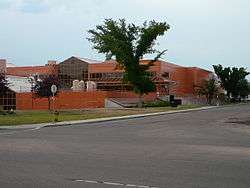 The MacEwan University Centre for the Arts is located in West Jasper Place | |
|
West Jasper Place Location of West Jasper Place in Edmonton | |
| Coordinates: 53°32′13″N 113°35′06″W / 53.537°N 113.585°W | |
| Country |
|
| Province |
|
| City | Edmonton |
| Quadrant[1] | NW |
| Ward[1] | 1 |
| Sector[2] | Mature area |
| Area[3][4] | Jasper Place |
| Government[5] | |
| • Administrative body | Edmonton City Council |
| • Councillor | Linda Sloan |
| Area[6] | |
| • Total | 0.89 km2 (0.34 sq mi) |
| Elevation | 673 m (2,208 ft) |
| Population (2012)[7] | |
| • Total | 2,966 |
| • Density | 3,332.6/km2 (8,631/sq mi) |
| • Change (2009–12) |
|
| • Dwellings | 1,696 |
West Jasper Place is a residential neighbourhood in west Edmonton, Alberta, Canada. Originally part of the Town of Jasper Place, West Jasper Place became a part of Edmonton when Edmonton and Jasper Place amalgamated on August 17, 1964.
While most of the neighbourhood is residential, there is some commercial development, with most of this adjacent to Stony Plain Road at the neighbourhood's north end. This development includes the Jasper Gates shopping centre.
Note that, during the 1980s and 1990s, Edmonton Transit System buses travelling out to locations west of 170 Street showed a destination of West Jasper Place. This meant a bus route with a destination west of the old Jasper Place townsite, rather than a bus route with the neighbourhood of West Jasper Place as the destination. Bus routes terminating in the old townsite area usually showed a destination of Jasper Place.
The neighbourhood is bounded by 149 Street on the east, 95 Avenue on the south, 156 Street on the west, and Stony Plain Road on the North.
The community is represented by the West Jasper/Sherwood Community League. Which maintains a community hall, outdoor rink and tennis courts located at 152 Street and 96 Avenue.[8][9] The West Jasper Place Community League operated as a separate entity from 1950 until 1985 when it merged with the Sherwood Community League.[9]
Demographics
In the City of Edmonton's 2012 municipal census, West Jasper Place had a population of 2,966 living in 1,696 dwellings,[7] a -2.9% change from its 2009 population of 3,055.[10] With a land area of 0.89 km2 (0.34 sq mi),[6] it had a population density of 3,332.6 people/km2 in 2012.[7][6]
According to the 2005 municipal census, one in five (17.9%) of the population moved into the neighbourhood within the previous 12 months. Another one in four (23.9%) had moved within the previous one to three years. Only two out of every five (42.7%) had lived at the same address for five years or more.[11] This is similar to the city at large.[12]
Just over half (51%) were male and just under half (49%) were female.
Residential development
According to the 2001 federal census, just under one third (29.4%) of the residential dwellings in the neighbourhood were built prior to the 1964 amalgamation of Jasper Place and Edmonton, with a significant number of those being built prior to the 1945 end of World War II. Approximately half (48.2%) of the residences were built between 1960 and 1980. The remaining 22.4% were built after 1980, with a particular spike in residential construction occurring in a short span during the early 1990s, when one in ten (11.7%) of residences were constructed.[13]
In 2005, three out of every five residences (59.3%) were rented apartments, including a small number of apartment style condominiums. Most of these are in low rise buildings with fewer than five stories. Another third of the residences (35.5%) were single detached houses. A small number (5%) were duplexes.[14]
Approximately two out of every three (68%) of all residences are rented.[15]
Schools
There is a single school at the southern edge of the neighbourhood, Sherwood Elementary School, operated by the Edmonton Public School System.
The now-closed Centre for the Arts Campus (formerly Jasper Place Campus) of MacEwan University is located near the north west corner of the neighbourhood.
Parks and green space
There is a single park in the neighbourhood, Arthur Elliot Park.
Bike trails in the MacKinnon Ravine, located just across 149 Street in the Crestwood neighbourhood, provide access to the city's River Valley Park System.
Jasper Place Transit Centre
Jasper Place Transit Centre | |
|---|---|
| Platforms | 9 bus bays[16] |
| Construction | |
| Parking | No |
| Disabled access | Yes |
| Other information | |
| Website | Jasper Place Transit Centre |
The Jasper Place Transit Centre is located on the northern end of the neighborhood at 157 street and Stony Plain Road. There are few amenities at this transit centre except for a shelter and pay phone (there are no washrooms, park and ride, drop off areas, or vending machines).[17]
The transit centre is currently undergoing an overhaul of the bus ways, sidewalks, medians, and shelter, among other changes as part of a city-wide $37.75 million transit centre improvement initiative.[18] $3.639 million in funding for the Jasper Place Transit Centre renewal project was provided by the federal government.[19] Reconstruction is scheduled to finish on October 1, 2018. During this construction all bus stops are temporarily located on Stony Plain Road and 100A Avenue.[17][20]
The following bus routes serve the transit centre:[21]
| Destination | Routes |
|---|---|
| Belvedere Transit Centre | 125 |
| Capilano Transit Centre | 1 |
| Coliseum Transit Centre | 125 |
| Cromdale | 3 |
| Downtown | 1, 3, 7, 14, 109, 111, 120, 311 |
| Eaux Claires Transit Centre | 150 |
| Kingsway Royal Alex Transit Centre | 125 |
| Mayfield Common | 114, 317 |
| Meadowlark Transit Centre | 1, 118, 310 |
| Mistatim Industrial | 121, 124 |
| Northgate Transit Centre | 121, 124, 150 |
| Rio Terrace | 118, 310 |
| Stadium Transit Centre | 120, 125 |
| University Transit Centre | 7 |
| West Edmonton Mall Transit Centre | 1, 14, 109, 111, 113, 150, 311 |
| Westmount Transit Centre | 121, 123, 124, 125, 150 |
| Whyte Ave | 7 |
| Winterburn | 114, 317 |
School special routes that arrive/depart from Jasper Place Transit Centre include routes: 706, 708, 802, 808 and 819.[22]
Surrounding neighbourhoods
Adjacent neighbourhoods are Crestwood, Parkview, Sherwood, Meadowlark Park, Glenwood, Britannia-Youngstown, Canora and Grovenor. These are all residential neighbourhoods.
Places adjacent to West Jasper Place, Edmonton | ||||||||||
|---|---|---|---|---|---|---|---|---|---|---|
| ||||||||||
See also
References
- 1 2 "City of Edmonton Wards & Standard Neighbourhoods" (PDF). City of Edmonton. Retrieved February 13, 2013.
- ↑ "Edmonton Developing and Planned Neighbourhoods, 2011" (PDF). City of Edmonton. Retrieved February 13, 2013.
- ↑ "The Way We Grow: Municipal Development Plan Bylaw 15100" (PDF). City of Edmonton. 2010-05-26. Retrieved February 13, 2013.
- ↑ "City of Edmonton Plans in Effect" (PDF). City of Edmonton. November 2011. Retrieved February 13, 2013.
- ↑ "City Councillors". City of Edmonton. Retrieved February 13, 2013.
- 1 2 3 "Neighbourhoods (data plus kml file)". City of Edmonton. Retrieved February 22, 2013.
- 1 2 3 "Municipal Census Results – Edmonton 2012 Census". City of Edmonton. Retrieved February 22, 2013.
- ↑ "West Jasper/Sherwood Community League". West Jasper/Sherwood Community League. Retrieved October 14, 2017.
- 1 2 Kuban, Ron (2005). Edmonton's Urban Villages: The Community League Movement. University of Alberta Press. ISBN 9781459303249.
- ↑ "2009 Municipal Census Results". City of Edmonton. Retrieved February 22, 2013.
- ↑
- ↑
- ↑ http://censusdocs.edmonton.ca/DD23/FEDERAL%202001/Neighbourhood/WEST%20JASPER%20PLACE.pdf
- ↑
- ↑
- ↑ "Jasper Place Transit Centre Map" (PDF). City of Edmonton. Retrieved September 29, 2017.
- 1 2 "Jasper Place Transit Centre". City of Edmonton. Retrieved September 29, 2017.
- ↑ Simes, Jeremy (May 12, 2017). "Edmonton to begin replacing transit centres this summer". Metro News. Archived from the original on 13 March 2018. Retrieved February 18, 2018.
- ↑ "Federal Government Infrastructure Investments in Alberta Examples". Government of Alberta. Retrieved 16 March 2018.
- ↑ "Jasper Place Transit Centre Total Closure". City of Edmonton. Retrieved February 18, 2018.
- ↑ "Brochures in PDF". City of Edmonton. Retrieved September 28, 2017.
- ↑ "School Service: ETS Trip Planner". City of Edmonton. Retrieved September 28, 2017.