Westmoreland Street
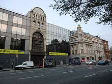
Westmoreland Street is a street in the southern city-centre of Dublin, Ireland. It is currently a one-way street and part a north-bound section of the R138 road.
Location
It is one of the two broad avenues - along with D'Olier Street - that converge at their northern ends at O'Connell Bridge over the River Liffey.[1] Westmoreland Street links the bridge to Trinity College at College Green at its southern end, from where traffic diverges between Grafton Street to the south and Dame Street to the west. Westmoreland Street also constitutes the eastern border of Temple Bar.
Name and history
The street is named after John Fane, 10th Earl of Westmorland, who was Lord Lieutenant of Ireland from 1789 to 1794.[2]
Luas
Luas Green Line | |||||||||||||||||||||||||||||||||||||||||||||||||||||||||||||||||||||||||||||||||||||||||||||||||||||||||||||||||||||||||||||||||||||||||||||||||||||||||||||||||||||||||||||||||||||||||||||||||||||||||||||||||||||||||||||||||||||||||||||||||||||||||||||||||||||||||||||||||||||||||||||||||||||||||||||||||||||||||||||||||||||||||||||||||||||||||||||||||||||||||||||||||||||||||||||||||||||||||||||||||||||||||||||||||||||||||||||||||||||||||||||||||||||||||||||||||
|---|---|---|---|---|---|---|---|---|---|---|---|---|---|---|---|---|---|---|---|---|---|---|---|---|---|---|---|---|---|---|---|---|---|---|---|---|---|---|---|---|---|---|---|---|---|---|---|---|---|---|---|---|---|---|---|---|---|---|---|---|---|---|---|---|---|---|---|---|---|---|---|---|---|---|---|---|---|---|---|---|---|---|---|---|---|---|---|---|---|---|---|---|---|---|---|---|---|---|---|---|---|---|---|---|---|---|---|---|---|---|---|---|---|---|---|---|---|---|---|---|---|---|---|---|---|---|---|---|---|---|---|---|---|---|---|---|---|---|---|---|---|---|---|---|---|---|---|---|---|---|---|---|---|---|---|---|---|---|---|---|---|---|---|---|---|---|---|---|---|---|---|---|---|---|---|---|---|---|---|---|---|---|---|---|---|---|---|---|---|---|---|---|---|---|---|---|---|---|---|---|---|---|---|---|---|---|---|---|---|---|---|---|---|---|---|---|---|---|---|---|---|---|---|---|---|---|---|---|---|---|---|---|---|---|---|---|---|---|---|---|---|---|---|---|---|---|---|---|---|---|---|---|---|---|---|---|---|---|---|---|---|---|---|---|---|---|---|---|---|---|---|---|---|---|---|---|---|---|---|---|---|---|---|---|---|---|---|---|---|---|---|---|---|---|---|---|---|---|---|---|---|---|---|---|---|---|---|---|---|---|---|---|---|---|---|---|---|---|---|---|---|---|---|---|---|---|---|---|---|---|---|---|---|---|---|---|---|---|---|---|---|---|---|---|---|---|---|---|---|---|---|---|---|---|---|---|---|---|---|---|---|---|---|---|---|---|---|---|---|---|---|---|---|---|---|---|---|---|---|---|---|---|---|---|---|---|---|---|---|---|---|---|---|---|---|---|---|---|---|---|---|---|---|---|---|---|---|---|---|---|---|---|---|---|---|---|---|---|---|---|---|---|---|---|---|---|---|---|---|---|---|---|---|---|---|---|---|---|---|---|---|---|---|---|---|---|---|---|---|---|---|---|---|---|---|---|---|---|---|---|---|---|---|---|---|
| |||||||||||||||||||||||||||||||||||||||||||||||||||||||||||||||||||||||||||||||||||||||||||||||||||||||||||||||||||||||||||||||||||||||||||||||||||||||||||||||||||||||||||||||||||||||||||||||||||||||||||||||||||||||||||||||||||||||||||||||||||||||||||||||||||||||||||||||||||||||||||||||||||||||||||||||||||||||||||||||||||||||||||||||||||||||||||||||||||||||||||||||||||||||||||||||||||||||||||||||||||||||||||||||||||||||||||||||||||||||||||||||||||||||||||||||||
Westmoreland street has a stop on the Luas Cross City line (northbound only). This line connects with the Red line and runs from Broombridge in North Dublin and Brise's Glen. Construction started in June 2013 with services beginning in December 2017.[3][4]
References
- ↑ Christine Casey. Dublin: The City Within the Grand and Royal Canals and the Circular Road, with the Phoenix Park. Yale University Press, 2006. ISBN 978-0-300-10923-8; pp. 420–424
- ↑ Bardon, Carol and Jonathan (1988). If Ever You Go to Dublin Town. Belfast: The Blackstaff Press. p. 98. ISBN 0-85640-397-0.
- ↑ "Green light given to Luas link-up, first passengers 2017". RTÉ. Archived from the original on 5 August 2012. Retrieved 5 August 2012.
- ↑ "Taoiseach launches new Luas Cross City service in Dublin". RTÉ. 9 December 2017. Retrieved 9 December 2017.
Coordinates: 53°20′44.64″N 6°15′32.81″W / 53.3457333°N 6.2591139°W