Balally
| Balally Baile Amhlaoibh | |
|---|---|
| Suburb of Dublin | |
 Balally Location in Ireland | |
| Coordinates: 53°16′48″N 6°13′55″W / 53.280°N 6.232°WCoordinates: 53°16′48″N 6°13′55″W / 53.280°N 6.232°W | |
| Country | Ireland |
| Province | Leinster |
| County | County Dublin |
| Area | |
| • Suburb of Dublin | 17 km2 (7 sq mi) |
| Population (2006) | |
| • Urban | 4,894 |
| Time zone | UTC+0 (WET) |
| • Summer (DST) | UTC-1 (IST (WEST)) |
Balally (Irish: Baile Amhlaoibh, meaning "Olafs' Town"), Dublin, Ireland, is a residential area at the southern end of Dundrum, Dublin between Dundrum village and the Sandyford Industrial Estate in Sandyford.
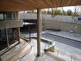
Balally Parish itself reaches from Ardglas to the M50 motorway. It has 2 primary schools (St. Olaf's National School and Queen of Angels) and 2 secondary schools (St. Tiernan's and Wesley College). Balally is part of the conurbation of Greater Dublin, in the county of Dún Laoghaire–Rathdown. The area contains a Luas tram station, located near the southern entrance to the new Dundrum Town Centre.
It was originally farmland and is located at the foot of the Wicklow Mountains. It consists of: Balally Drive, Balally Hill, Balally Grove, Balally Close, Balally Park, Balally Avenue & Balally Road, and Sandyford Road. It has been re-connected to Sandyford Road at Balally Hill after access was closed off due to cars cutting through the estate to beat the traffic congestion.
Name
The area is named after Olaf (Amhlaoibh), the first King of Viking Dublin, who is reputed to have built a fort in the locality. The place name Baile Mhic Amhlaoibh, meaning "the town of the son of Olaf" was anglicised as Balally.
Education
The local primary school, St. Olaf's National School, has more than 350 students. The Church of the Ascension of the Lord, the local Roman Catholic church, was built in 1982.
Churches
The Church of the Ascension of the Lord, the local Roman Catholic church, was built in October 1982.
Transport
It is serviced by the buses: 44, 44B and 116. The 44 travels on to Enniskerry in the south and Larkhill to the north and runs hourly seven days a week. The 44B service operates Monday to Friday, in the early morning and early evening between Dundrum and Glencullen. The 116 also serves the area, going from Lesson Street once a day Monday to Friday in the afternoon and once in the morning to Parnell Square. The light rail rapid transit system, Luas stops in Ballaly and connects the suburb to Bride's Glen in the south and the City Centre and Broombridge in the North. By 2027, the new planned Dublin Metro, Metrolink will stop alongside Ballaly's Luas station on its way from Swords to Sandyford.[1]
| Preceding station | Luas | Following station | ||
|---|---|---|---|---|
| Dundrum | Green Line | Kilmacud | ||
| Future | ||||
| Preceding station | Dublin Metro | Following station | ||
| Dundrum | Metrolink | Kilmacud | ||
Sport
- Naomh Olaf is the local Gaelic Athletic Association club and Balally Celtic is the local Football club.
Residents Association
- Balally Residents Association has been in existence since 1964. It represents the interests of residents in Balally estate as well as the local Sandyford Road. It ensures that the estate is well maintained as well as organising various social events throughout the year.