College Green
.jpg)
College Green (Irish: Faiche an Choláiste) is a three-sided plaza in the centre of Dublin, Ireland. On its northern side is the Bank of Ireland building, which until 1800 was Ireland's Parliament House. To its east stands Trinity College Dublin. To its south stands a series of 19th-century buildings that are mostly banks.
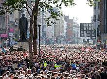
Streets leading onto College Green are Dame Street to the west, Grafton Street to the south, and Westmoreland Street to the north. College Green has been used as an assembly point for major political rallies. In the mid-1990s, United States President Bill Clinton addressed a crowd during his visit to Ireland. President Barack Obama spoke at the site in a major address during his visit in May 2011.[1]
The area was once known as Hoggen Green from the Old Norse word haugr meaning mound, or barrow. The cemetery at College Green consisted of several burial mounds, which are thought to have contained the remains of some of the Norse kings of Dublin.[2] Between Church Lane and Suffolk Street the Norse had their Thing, an assembly and meeting-place, which was still to be seen in the 17th century. All along College Green, called Hoggen Green by the English, lay their barrows.[3] Hoggen gave its name to the convent of St Mary de Hogges, which stood roughly where the Bank of Ireland is now, and was a major landowner in the area until the Reformation.

Two major public monuments stand in College Green:
A 19th-century statue of Henry Grattan, one of the leading members of the old Irish Parliament, stands facing Trinity College.
Further back stands a statue of patriot Thomas Davis. Previously, this was the location of one of Dublin's finest equestrian statues, of King William III of England (William of Orange) on horseback, by Grinling Gibbons, which features in James Joyce's story The Dead. It was taken down after it was badly damaged in an explosion in November 1928.
Daly's Club, originally frequented by members of the old Irish Parliament, moved to number 3, College Green, in 1791 and remained there until it closed in the 1820s.[4]
College Green now exists as a street running from the front gates of Trinity College Dublin to pedestrian traffic lights close to The Central Bank in Dame Street at the junction of Trinity Street. The houses are numbered starting with 1 on the north side of the Street at Westmoreland Street and Trinity College and continuing across to the south side and back on the opposite side to Trinity College and the bottom of Grafton Street. Dubliners often incorrectly identify the street as Dame Street because it continues into Dame Street. College Street which runs from Pearse Street and Westmoreland Street passing railings on the Northern side of Trinity College Dublin is often thought to be College Green.

Traffic restriction
Since July 2009, College Green, during peak times on working days, has been accessible only to pedestrians, buses, taxis and cyclists.[5]
In February 2016, it was announced that most of College Green would be pedestrianised to create a large public space in front of the Bank of Ireland. A plan banning all East-West traffic movements at College Green except for pedestrians and cyclists has been referred to An Bord Pleanala, the state planning agency, with a decision expected around August 2017.[6]
See also
References
- ↑ Henry McDonald (23 May 2011). "Barack Obama cuts short Ireland visit after concerns over volcanic ash cloud". The Guardian. Retrieved 23 May 2011.
- ↑ Hoggen Green ("Vikings in Dublin or Dyflin as they called it". Robert O'Connor. Viking Network)
- ↑ Scandinavian Relations With Ireland During the Viking Period (A. Walsh, author. Dublin: The Talbot Press Limited. 1922)
- ↑ T. H. S. Escott, Club Makers and Club Members (1913), pp. 329–333
- ↑ "Change to College Green traffic restrictions". 18 November 2009. Retrieved 20 December 2016.
- ↑ "College Green pedestrianisation plans to go before An Bord Pleanála". 4 October 2016. Retrieved 20 December 2016.