Westervelt, Illinois
| Westervelt, Illinois | |
|---|---|
| Census-designated place | |
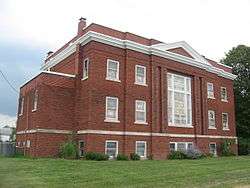 Westervelt Christian Church | |
 Westervelt, Illinois | |
| Coordinates: 39°28′44″N 88°51′42″W / 39.47889°N 88.86167°WCoordinates: 39°28′44″N 88°51′42″W / 39.47889°N 88.86167°W | |
| Country |
|
| State |
|
| County | Shelby |
| Township | Ridge |
| Area | |
| • Total | 0.22 km2 (0.086 sq mi) |
| • Land | 0.22 km2 (0.086 sq mi) |
| • Water | 0 km2 (0 sq mi) |
| Elevation | 199 m (653 ft) |
| Population (2010)[1] | |
| • Total | 128 |
| • Density | 570/km2 (1,500/sq mi) |
| Time zone | UTC-6 (Central (CST)) |
| • Summer (DST) | UTC-5 (CDT) |
| ZIP Code | 62565 |
| Area code(s) | 217 |
| GNIS feature ID | 420959[2] |
Westervelt is a census-designated place in Shelby County, Illinois, United States. Its population was 128 as of the 2010 census.[1]
History
Westervelt was established in 1904 as a station along the Chicago and Eastern Illinois Railroad, which had recently opened a line through the area. The station drew settlers and businesses from the nearby community of Brunswick, and the new community grew quickly. A 1917 tornado killed six residents and destroyed nine buildings.[3]
The Westervelt Christian Church is listed on the National Register of Historic Places.[4]
References
- 1 2 "American FactFinder". U.S. Census Bureau. Retrieved 21 March 2011.
- ↑ U.S. Geological Survey Geographic Names Information System: Westervelt, Illinois
- ↑ McCain, June; William Gatlin (September 2005). "National Register of Historic Places Registration Form: Westervelt Christian Church" (PDF). National Park Service. Retrieved March 13, 2014.
- ↑ National Park Service (2010-07-09). "National Register Information System". National Register of Historic Places. National Park Service.
Municipalities and communities of Shelby County, Illinois, United States | ||
|---|---|---|
| Cities | ||
| Towns | ||
| Villages | ||
| Townships | ||
| CDP | ||
| Other unincorporated communities |
| |
| Footnotes | ‡This populated place also has portions in an adjacent county or counties | |
This article is issued from
Wikipedia.
The text is licensed under Creative Commons - Attribution - Sharealike.
Additional terms may apply for the media files.