Western Province (Papua New Guinea)
| Western Province Fly River Province | ||
|---|---|---|
|
| ||
| ||
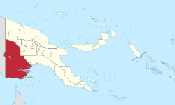 Western Province in Papua New Guinea | ||
| Coordinates: 7°20′S 142°0′E / 7.333°S 142.000°E | ||
| Country | Papua New Guinea | |
| Capital | Daru | |
| Districts | ||
| Government | ||
| • Governor | Roy Biyama (since 2017) | |
| Area | ||
| • Total | 98,189 km2 (37,911 sq mi) | |
| Population (2011 census) | ||
| • Total | 201,351 | |
| • Density | 2.1/km2 (5.3/sq mi) | |
| Time zone | UTC+10 (AEST) | |
Western Province is a coastal province in southwestern Papua New Guinea, bordering the Indonesian province of Papua. The provincial capital is Daru. The largest town in the province is Tabubil. Other major settlements are Kiunga, Ningerum, Olsobip and Balimo.
The provincial government has, as with the governments of North Solomons, Chimbu and Northern provinces, sought to change the name of the province. The government uses the name Fly River Provincial Government; however, this remains unofficial as it has not been changed in the Constitution of Papua New Guinea.
Geography and ecology
Western Province covers 99,300 km² and is the largest province in Papua New Guinea by area.[1][2] There are several large rivers that run through the province, including the Fly River and its tributaries the Strickland and Ok Tedi rivers. The largest lake in Papua New Guinea, Lake Murray, is also in Western Province.[3]
This province is the only part of Papua New Guinea to hold land west of the 141°E line, which divides it from Indonesian Western New Guinea. This is a small section of territory bordered by the Fly River.[4]
The Tonda Wildlife Management Area in the south-western corner of the province is a wetland of international importance.[5] It is the largest protected area in Papua New Guinea.[6]
Demographics
There were 201,351 inhabitants in Western Province in the 2011 census, residing in 31,322 households. Of these, 79,349 people were recorded in Middle Fly District, 62,850 in North Fly District and 59,152 in South Fly District. The average household size across the province was 6.4.[7]
Economy
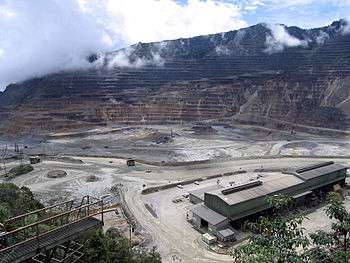
The major economic activity in the province is constituted by the Ok Tedi Mine, initially established by BHP and the subject of considerable litigation by traditional landowners both in respect of environmental degradation and disputes over royalties. It is currently operated by Ok Tedi Mining Limited (OTML).[8]
Districts and LLGs
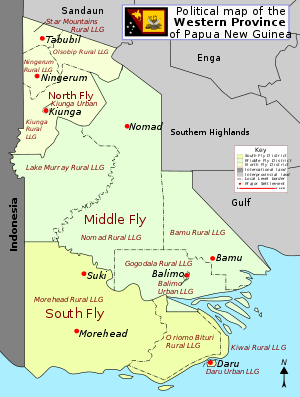
There are three districts in the province. Each district has one or more Local Level Government (LLG) areas. For census purposes, the LLG areas are subdivided into wards and those into census units.[9]
| District | District Capital | LLG Name |
|---|---|---|
| North Fly District | Kiunga | Kiunga Rural |
| Kiunga Urban | ||
| Ningerum Rural | ||
| Olsobip Rural | ||
| Star Mountains Rural | ||
| Middle Fly District | Balimo | Balimo Urban |
| Bamu Rural | ||
| Gogodala Rural | ||
| Lake Murray Rural | ||
| Nomad Rural | ||
| South Fly District | Daru | Daru Urban |
| Kiwai Rural | ||
| Morehead Rural | ||
| Oriomo-Bituri Rural |
Provincial leaders
The province was governed by a decentralised provincial administration, headed by a Premier, from 1977 to 1995. Following reforms taking effect that year, the national government reassumed some powers, and the role of Premier was replaced by a position of Governor, to be held by the winner of the province-wide seat in the National Parliament of Papua New Guinea.[10][11]
Premiers (1977–1995)
| Premier | Term |
|---|---|
| Tatie Olewale | 1977–1983 |
| Semai Aitowai | 1983–1985 |
| provincial government suspended | 1985–1988 |
| Norbert Makmop | 1988–1991 |
| Isidore Kaseng | 1992–1995 |
Governors (1995–present)
| Premier | Term |
|---|---|
| Dere Wamaro | 1992–1997 |
| Norbert Makmop | 1997–2002 |
| Bob Danaya | 2002–2012 |
| Ati Wobiro | 2012–2017 |
| Taboi Awe Yoto | 2017–present |
Members of the National Parliament
The province and each district is represented by a Member of the National Parliament. There is one provincial electorate and each district is an open electorate.
| Premier | Term |
|---|---|
| Western Provincial | Taboi Awi Yotto |
| North Fly Open | James Donald |
| Middle Fly Open | Roy Biyama |
| South Fly Open | Sekie Agisa |
See also
- Hindenburg Range
- Hindenburg Wall
- Star Mountains
- Kiunga-Tabubil Highway
References
- ↑ Papua New Guinea 2000 Census: Western. National Statistical Office. p. 7.
- ↑ Strategic Directions for Human Development in Papua New Guinea. Australian Agency for International Development. 2007. p. 180.
- ↑ "Western". Papua New Guinea Tourism Promotion Authority. Retrieved 1 April 2017.
- ↑ Frank Jacobs (March 13, 2012). "Who Bit My Border?". The New York Times.
- ↑ Ramsar report for Tonda Wildlife Management Area Archived September 27, 2009, at the Wayback Machine., retrieved 28 June 2010
- ↑ UNESCO: Trans-Fly Complex, retrieved 28 June 2010
- ↑ "Final Figures Booklet". National Population & Housing Census 2011. Retrieved 31 March 2017.
- ↑ "Social Impact of the Ok Tedi Mine on the Yonggom Villages of the North Fly, 1992" (PDF). Ok-Fly Social Monitoring Project Report No. 5. Retrieved 1 April 2017.
- ↑ National Statistical Office of Papua New Guinea
- ↑ May, R. J. "8. Decentralisation: Two Steps Forward, One Step Back". State and society in Papua New Guinea: the first twenty-five years. Australian National University. Retrieved 31 March 2017.
- ↑ "Provinces". rulers.org. Retrieved 31 March 2017.